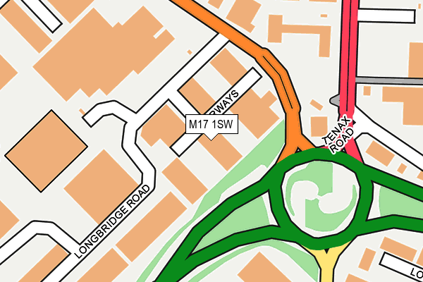
M17 1SW lies on Fourways Trading Estate in Trafford Park, Manchester. M17 1SW is located in the Gorse Hill & Cornbrook electoral ward, within the metropolitan district of Trafford and the English Parliamentary constituency of Stretford and Urmston. The Sub Integrated Care Board (ICB) Location is NHS Greater Manchester ICB - 02A and the police force is Greater Manchester. This postcode has been in use since May 1994.


GetTheData
Source: OS OpenMap – Local (Ordnance Survey)
Source: OS VectorMap District (Ordnance Survey)
Licence: Open Government Licence (requires attribution)
| Easting | 378271 |
| Northing | 396935 |
| Latitude | 53.468716 |
| Longitude | -2.328794 |
GetTheData
Source: Open Postcode Geo
Licence: Open Government Licence
| Street | Fourways Trading Estate |
| Locality | Trafford Park |
| Town/City | Manchester |
| Country | England |
| Postcode District | M17 |
➜ See where M17 is on a map ➜ Where is Trafford Park? | |
GetTheData
Source: Land Registry Price Paid Data
Licence: Open Government Licence
Elevation or altitude of M17 1SW as distance above sea level:
| Metres | Feet | |
|---|---|---|
| Elevation | 30m | 98ft |
Elevation is measured from the approximate centre of the postcode, to the nearest point on an OS contour line from OS Terrain 50, which has contour spacing of ten vertical metres.
➜ How high above sea level am I? Find the elevation of your current position using your device's GPS.
GetTheData
Source: Open Postcode Elevation
Licence: Open Government Licence
| Ward | Gorse Hill & Cornbrook |
| Constituency | Stretford And Urmston |
GetTheData
Source: ONS Postcode Database
Licence: Open Government Licence
| Ashburton Road West/Park Way (Ashburton Rd W) | Trafford Park | 176m |
| Ashburton Road West/Park Way (Ashburton Rd W) | Trafford Park | 204m |
| Ashburton Road West/Lyons Road (Ashburton Rd W) | Trafford Park | 278m |
| Ashburton Rd West/Lyons Rd (Ashburton Rd W) | Trafford Park | 295m |
| Ashburton Rd West/Richmond Rd (Ashburton Rd W) | Trafford Park | 440m |
| Humphrey Park Station | 1.8km |
| Eccles Station | 1.9km |
| Trafford Park Station | 2km |
GetTheData
Source: NaPTAN
Licence: Open Government Licence
| Median download speed | 80.0Mbps |
| Average download speed | 64.4Mbps |
| Maximum download speed | 80.00Mbps |
| Median upload speed | 20.0Mbps |
| Average upload speed | 16.1Mbps |
| Maximum upload speed | 20.00Mbps |
GetTheData
Source: Ofcom
Licence: Ofcom Terms of Use (requires attribution)
GetTheData
Source: ONS Postcode Database
Licence: Open Government Licence


➜ Get more ratings from the Food Standards Agency
GetTheData
Source: Food Standards Agency
Licence: FSA terms & conditions
| Last Collection | |||
|---|---|---|---|
| Location | Mon-Fri | Sat | Distance |
| Bailey Road/Ashburton Road | 17:30 | 11:45 | 372m |
| 17 Longwood Road | 17:30 | 12:00 | 476m |
| Opp Unit 6 Mosley Road | 17:30 | 11:45 | 868m |
GetTheData
Source: Dracos
Licence: Creative Commons Attribution-ShareAlike
The below table lists the International Territorial Level (ITL) codes (formerly Nomenclature of Territorial Units for Statistics (NUTS) codes) and Local Administrative Units (LAU) codes for M17 1SW:
| ITL 1 Code | Name |
|---|---|
| TLD | North West (England) |
| ITL 2 Code | Name |
| TLD3 | Greater Manchester |
| ITL 3 Code | Name |
| TLD34 | Greater Manchester South West |
| LAU 1 Code | Name |
| E08000009 | Trafford |
GetTheData
Source: ONS Postcode Directory
Licence: Open Government Licence
The below table lists the Census Output Area (OA), Lower Layer Super Output Area (LSOA), and Middle Layer Super Output Area (MSOA) for M17 1SW:
| Code | Name | |
|---|---|---|
| OA | E00030979 | |
| LSOA | E01006121 | Trafford 002E |
| MSOA | E02001260 | Trafford 002 |
GetTheData
Source: ONS Postcode Directory
Licence: Open Government Licence
| M17 1RN | Lyons Road | 442m |
| M17 1JT | Tenax Road | 516m |
| M17 1RW | Broadoak Business Park | 575m |
| M41 7JE | Trafford Boulevard | 575m |
| M41 7LJ | Platinum Road | 582m |
| M17 1SF | Kestrel Road | 801m |
| M17 1SG | Enterprise Trading Estate | 928m |
| M32 0UT | Lumsdale Road | 972m |
| M17 1GA | Acheson Way | 975m |
| M32 0QY | Blackmore Road | 982m |
GetTheData
Source: Open Postcode Geo; Land Registry Price Paid Data
Licence: Open Government Licence