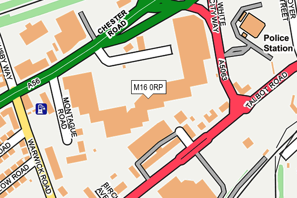
M16 0RP is located in the Gorse Hill & Cornbrook electoral ward, within the metropolitan district of Trafford and the English Parliamentary constituency of Stretford and Urmston. The Sub Integrated Care Board (ICB) Location is NHS Greater Manchester ICB - 02A and the police force is Greater Manchester. This postcode has been in use since July 1990.


GetTheData
Source: OS OpenMap – Local (Ordnance Survey)
Source: OS VectorMap District (Ordnance Survey)
Licence: Open Government Licence (requires attribution)
| Easting | 381262 |
| Northing | 396091 |
| Latitude | 53.461245 |
| Longitude | -2.283688 |
GetTheData
Source: Open Postcode Geo
Licence: Open Government Licence
| Country | England |
| Postcode District | M16 |
➜ See where M16 is on a map ➜ Where is Old Trafford? | |
GetTheData
Source: Land Registry Price Paid Data
Licence: Open Government Licence
Elevation or altitude of M16 0RP as distance above sea level:
| Metres | Feet | |
|---|---|---|
| Elevation | 30m | 98ft |
Elevation is measured from the approximate centre of the postcode, to the nearest point on an OS contour line from OS Terrain 50, which has contour spacing of ten vertical metres.
➜ How high above sea level am I? Find the elevation of your current position using your device's GPS.
GetTheData
Source: Open Postcode Elevation
Licence: Open Government Licence
| Ward | Gorse Hill & Cornbrook |
| Constituency | Stretford And Urmston |
GetTheData
Source: ONS Postcode Database
Licence: Open Government Licence
| Chester Road/White City (Chester Road) | Old Trafford | 123m |
| Chester Road/White City (Chester Road) | Old Trafford | 126m |
| Talbot Road/Oaklands House (Talbot Road) | Old Trafford | 142m |
| White City Way (Opp Sj0871) (White City Way) | Old Trafford | 153m |
| White City Way/Chester Road (White City Way) | Old Trafford | 170m |
| Trafford Bar (Manchester Metrolink) (Seymour Grove) | Trafford Bar | 465m |
| Old Trafford (Manchester Metrolink) (Trafford Park Road) | Old Trafford | 554m |
| Pomona (Manchester Metrolink) (Pomona Strand) | Salford Quays | 562m |
| Exchange Quay (Manchester Metrolink) (Exchange Quay) | Salford Quays | 670m |
| Salford Quays (Manchester Metrolink) (St Peters Quay) | Salford Quays | 1,002m |
| Manchester United FC Station | 0.5km |
| Trafford Park Station | 1.9km |
| Deansgate Station | 2.6km |
GetTheData
Source: NaPTAN
Licence: Open Government Licence
| Median download speed | 74.0Mbps |
| Average download speed | 62.8Mbps |
| Maximum download speed | 80.00Mbps |
| Median upload speed | 20.0Mbps |
| Average upload speed | 16.0Mbps |
| Maximum upload speed | 20.00Mbps |
GetTheData
Source: Ofcom
Licence: Ofcom Terms of Use (requires attribution)
GetTheData
Source: ONS Postcode Database
Licence: Open Government Licence


➜ Get more ratings from the Food Standards Agency
GetTheData
Source: Food Standards Agency
Licence: FSA terms & conditions
| Last Collection | |||
|---|---|---|---|
| Location | Mon-Fri | Sat | Distance |
| 66 Talbot Road/Botanical Gdns | 17:30 | 11:45 | 104m |
| Botanical Gdns / Talbot Road | 107m | ||
| Warwick Road | 17:30 | 12:00 | 353m |
GetTheData
Source: Dracos
Licence: Creative Commons Attribution-ShareAlike
The below table lists the International Territorial Level (ITL) codes (formerly Nomenclature of Territorial Units for Statistics (NUTS) codes) and Local Administrative Units (LAU) codes for M16 0RP:
| ITL 1 Code | Name |
|---|---|
| TLD | North West (England) |
| ITL 2 Code | Name |
| TLD3 | Greater Manchester |
| ITL 3 Code | Name |
| TLD34 | Greater Manchester South West |
| LAU 1 Code | Name |
| E08000009 | Trafford |
GetTheData
Source: ONS Postcode Directory
Licence: Open Government Licence
The below table lists the Census Output Area (OA), Lower Layer Super Output Area (LSOA), and Middle Layer Super Output Area (MSOA) for M16 0RP:
| Code | Name | |
|---|---|---|
| OA | E00031368 | |
| LSOA | E01006186 | Trafford 003B |
| MSOA | E02001261 | Trafford 003 |
GetTheData
Source: ONS Postcode Directory
Licence: Open Government Licence
| M16 0PN | Talbot Road | 119m |
| M16 0QT | Montague Road | 189m |
| M16 0PW | Talbot Road | 207m |
| M16 0RZ | Warwick Road | 252m |
| M16 0QQ | Warwick Road | 271m |
| M32 0SF | Chester Road | 328m |
| M16 0QG | Sir Matt Busby Way | 335m |
| M32 0RG | Barlow Road | 353m |
| M32 0SE | Partridge Street | 355m |
| M32 0RQ | Hornby Road | 357m |
GetTheData
Source: Open Postcode Geo; Land Registry Price Paid Data
Licence: Open Government Licence