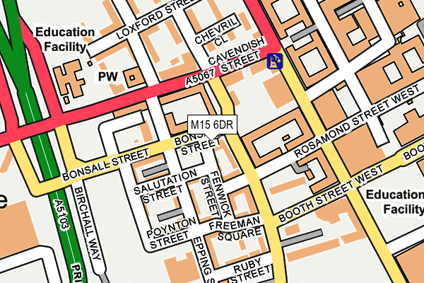
M15 6DR is located in the Hulme electoral ward, within the metropolitan district of Manchester and the English Parliamentary constituency of Manchester Central. The Sub Integrated Care Board (ICB) Location is NHS Greater Manchester ICB - 14L and the police force is Greater Manchester. This postcode has been in use since December 1996.


GetTheData
Source: OS OpenMap – Local (Ordnance Survey)
Source: OS VectorMap District (Ordnance Survey)
Licence: Open Government Licence (requires attribution)
| Easting | 384033 |
| Northing | 396818 |
| Latitude | 53.467855 |
| Longitude | -2.241990 |
GetTheData
Source: Open Postcode Geo
Licence: Open Government Licence
| Country | England |
| Postcode District | M15 |
➜ See where M15 is on a map ➜ Where is Manchester? | |
GetTheData
Source: Land Registry Price Paid Data
Licence: Open Government Licence
Elevation or altitude of M15 6DR as distance above sea level:
| Metres | Feet | |
|---|---|---|
| Elevation | 30m | 98ft |
Elevation is measured from the approximate centre of the postcode, to the nearest point on an OS contour line from OS Terrain 50, which has contour spacing of ten vertical metres.
➜ How high above sea level am I? Find the elevation of your current position using your device's GPS.
GetTheData
Source: Open Postcode Elevation
Licence: Open Government Licence
| Ward | Hulme |
| Constituency | Manchester Central |
GetTheData
Source: ONS Postcode Database
Licence: Open Government Licence
| Bonsall St/Boundary Ln (Bonsall St) | Hulme | 87m |
| Stretford Rd/Boundary Ln (Stretford Rd) | Chorlton Upon Medlock | 102m |
| Cambridge St/Cavendish St (Hr Cambridge St) | Chorlton Upon Medlock | 137m |
| Higher Cambridge St/Boundary St West (Hr Cambridge St) | Chorlton Upon Medlock | 150m |
| Stretford Rd/Boundary Ln (Stretford Rd) | Hulme | 152m |
| Deansgate-castlefield (Manchester Metrolink) (Whitworth Street West) | Manchester City Centre | 985m |
| St Peters Square (Manchester Metrolink) (Peter Street) | Manchester City Centre | 1,153m |
| Piccadilly (Manchester Metrolink) (London Road) | Manchester City Centre | 1,256m |
| Piccadilly Gardens (Manchester Metrolink) (Portland Street) | Piccadilly Gardens | 1,405m |
| New Islington (Manchester Metrolink) (Pollard Street) | New Islington | 2,082m |
| Manchester Oxford Road Station | 0.7km |
| Deansgate Station | 0.9km |
| Manchester Piccadilly Station | 1.3km |
GetTheData
Source: NaPTAN
Licence: Open Government Licence
GetTheData
Source: ONS Postcode Database
Licence: Open Government Licence


➜ Get more ratings from the Food Standards Agency
GetTheData
Source: Food Standards Agency
Licence: FSA terms & conditions
| Last Collection | |||
|---|---|---|---|
| Location | Mon-Fri | Sat | Distance |
| Woodcock Square | 17:30 | 12:00 | 91m |
| Brennan Close Arnott Cresent | 17:30 | 12:00 | 399m |
| Rosamund Street | 17:30 | 12:00 | 426m |
GetTheData
Source: Dracos
Licence: Creative Commons Attribution-ShareAlike
The below table lists the International Territorial Level (ITL) codes (formerly Nomenclature of Territorial Units for Statistics (NUTS) codes) and Local Administrative Units (LAU) codes for M15 6DR:
| ITL 1 Code | Name |
|---|---|
| TLD | North West (England) |
| ITL 2 Code | Name |
| TLD3 | Greater Manchester |
| ITL 3 Code | Name |
| TLD33 | Manchester |
| LAU 1 Code | Name |
| E08000003 | Manchester |
GetTheData
Source: ONS Postcode Directory
Licence: Open Government Licence
The below table lists the Census Output Area (OA), Lower Layer Super Output Area (LSOA), and Middle Layer Super Output Area (MSOA) for M15 6DR:
| Code | Name | |
|---|---|---|
| OA | E00026392 | |
| LSOA | E01005212 | Manchester 057A |
| MSOA | E02006914 | Manchester 057 |
GetTheData
Source: ONS Postcode Directory
Licence: Open Government Licence
| M15 6EH | Boundary Lane | 51m |
| M15 6JD | Boundary Lane | 86m |
| M15 6DT | Bonsall Street | 92m |
| M15 6BN | Cavendish Street | 92m |
| M15 6DY | Stretford Road | 125m |
| M15 6BF | Broomwood Walk | 135m |
| M15 6HF | Newcastle Street | 151m |
| M15 6HE | Stretford Road | 153m |
| M15 6DA | Knowles Place | 161m |
| M15 6BP | Cambridge Street | 171m |
GetTheData
Source: Open Postcode Geo; Land Registry Price Paid Data
Licence: Open Government Licence