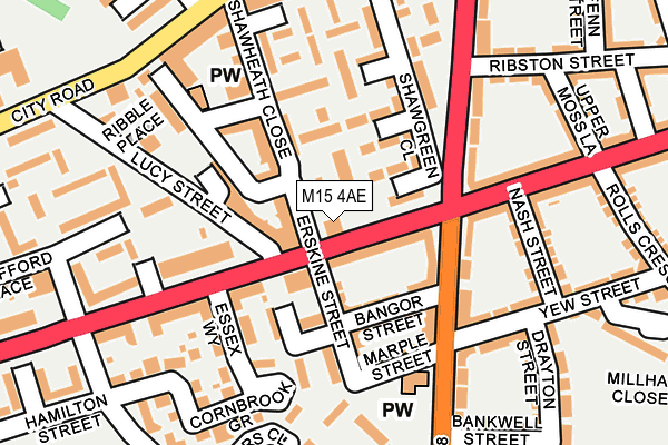
M15 4AE lies on Stretford Road in Manchester. M15 4AE is located in the Hulme electoral ward, within the metropolitan district of Manchester and the English Parliamentary constituency of Manchester Central. The Sub Integrated Care Board (ICB) Location is NHS Greater Manchester ICB - 14L and the police force is Greater Manchester. This postcode has been in use since January 1980.


GetTheData
Source: OS OpenMap – Local (Ordnance Survey)
Source: OS VectorMap District (Ordnance Survey)
Licence: Open Government Licence (requires attribution)
| Easting | 382867 |
| Northing | 396566 |
| Latitude | 53.465570 |
| Longitude | -2.259540 |
GetTheData
Source: Open Postcode Geo
Licence: Open Government Licence
| Street | Stretford Road |
| Town/City | Manchester |
| Country | England |
| Postcode District | M15 |
➜ See where M15 is on a map ➜ Where is Manchester? | |
GetTheData
Source: Land Registry Price Paid Data
Licence: Open Government Licence
Elevation or altitude of M15 4AE as distance above sea level:
| Metres | Feet | |
|---|---|---|
| Elevation | 30m | 98ft |
Elevation is measured from the approximate centre of the postcode, to the nearest point on an OS contour line from OS Terrain 50, which has contour spacing of ten vertical metres.
➜ How high above sea level am I? Find the elevation of your current position using your device's GPS.
GetTheData
Source: Open Postcode Elevation
Licence: Open Government Licence
| Ward | Hulme |
| Constituency | Manchester Central |
GetTheData
Source: ONS Postcode Database
Licence: Open Government Licence
| Stretford Rd/Chorlton Rd (Stretford Rd) | St Georges | 36m |
| Stretford Road/The Platford (Stretford Road) | St Georges | 50m |
| Chorlton Rd/Stretford Rd (Chorlton Rd) | Hulme | 136m |
| Chorlton Rd/Stretford Rd (Chorlton Rd) | St Georges | 155m |
| Chorlton Rd/Stretford Rd (Chorlton Rd) | Hulme | 156m |
| Cornbrook (Manchester Metrolink) | Cornbrook | 725m |
| Deansgate-castlefield (Manchester Metrolink) (Whitworth Street West) | Manchester City Centre | 1,160m |
| Trafford Bar (Manchester Metrolink) (Seymour Grove) | Trafford Bar | 1,214m |
| Pomona (Manchester Metrolink) (Pomona Strand) | Salford Quays | 1,248m |
| St Peters Square (Manchester Metrolink) (Peter Street) | Manchester City Centre | 1,780m |
| Deansgate Station | 1.1km |
| Manchester Oxford Road Station | 1.5km |
| Salford Central Station | 2km |
GetTheData
Source: NaPTAN
Licence: Open Government Licence
GetTheData
Source: ONS Postcode Database
Licence: Open Government Licence


➜ Get more ratings from the Food Standards Agency
GetTheData
Source: Food Standards Agency
Licence: FSA terms & conditions
| Last Collection | |||
|---|---|---|---|
| Location | Mon-Fri | Sat | Distance |
| Hullard Hall P.o. | 17:30 | 12:00 | 372m |
| City Road Brendans Irish Club | 17:30 | 12:00 | 394m |
| Shrewsbury Street | 17:30 | 12:00 | 506m |
GetTheData
Source: Dracos
Licence: Creative Commons Attribution-ShareAlike
The below table lists the International Territorial Level (ITL) codes (formerly Nomenclature of Territorial Units for Statistics (NUTS) codes) and Local Administrative Units (LAU) codes for M15 4AE:
| ITL 1 Code | Name |
|---|---|
| TLD | North West (England) |
| ITL 2 Code | Name |
| TLD3 | Greater Manchester |
| ITL 3 Code | Name |
| TLD33 | Manchester |
| LAU 1 Code | Name |
| E08000003 | Manchester |
GetTheData
Source: ONS Postcode Directory
Licence: Open Government Licence
The below table lists the Census Output Area (OA), Lower Layer Super Output Area (LSOA), and Middle Layer Super Output Area (MSOA) for M15 4AE:
| Code | Name | |
|---|---|---|
| OA | E00175922 | |
| LSOA | E01005213 | Manchester 059A |
| MSOA | E02006916 | Manchester 059 |
GetTheData
Source: ONS Postcode Directory
Licence: Open Government Licence
| M15 4BS | 44m | |
| M15 4AW | Stretford Road | 52m |
| M15 4BR | Erskine Street | 56m |
| M15 4AB | Percy Street | 61m |
| M15 4DR | Shawgreen Close | 77m |
| M15 4BW | Bangor Street | 86m |
| M15 4DY | St Lawrence Street | 93m |
| M15 4DP | Dillmoss Walk | 99m |
| M15 4GH | Browning Street | 101m |
| M15 4BP | Erskine Street | 103m |
GetTheData
Source: Open Postcode Geo; Land Registry Price Paid Data
Licence: Open Government Licence