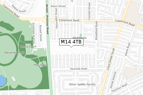
M14 4TB is located in the Whalley Range electoral ward, within the metropolitan district of Manchester and the English Parliamentary constituency of Manchester Central. The Sub Integrated Care Board (ICB) Location is NHS Greater Manchester ICB - 14L and the police force is Greater Manchester. This postcode has been in use since September 2019.


GetTheData
Source: OS Open Zoomstack (Ordnance Survey)
Licence: Open Government Licence (requires attribution)
Attribution: Contains OS data © Crown copyright and database right 2025
Source: Open Postcode Geo
Licence: Open Government Licence (requires attribution)
Attribution: Contains OS data © Crown copyright and database right 2025; Contains Royal Mail data © Royal Mail copyright and database right 2025; Source: Office for National Statistics licensed under the Open Government Licence v.3.0
| Easting | 383973 |
| Northing | 395036 |
| Latitude | 53.451852 |
| Longitude | -2.242802 |
GetTheData
Source: Open Postcode Geo
Licence: Open Government Licence
| Country | England |
| Postcode District | M14 |
➜ See where M14 is on a map ➜ Where is Manchester? | |
GetTheData
Source: Land Registry Price Paid Data
Licence: Open Government Licence
| Ward | Whalley Range |
| Constituency | Manchester Central |
GetTheData
Source: ONS Postcode Database
Licence: Open Government Licence
| Bowes St/Princess Rd (Bowes St) | Moss Side | 101m |
| Princess Rd/Alexandra Park (Princess Rd) | Moss Side | 131m |
| Princess Rd/Alexandra Park (Princess Rd) | Moss Side | 163m |
| Princess Rd/Claremont Rd (Princess Rd) | Moss Side | 256m |
| Claremont Rd/Princess Rd (Claremont Rd) | Moss Side | 277m |
| Manchester Oxford Road Station | 2.5km |
| Deansgate Station | 2.5km |
| Ardwick Station | 2.9km |
GetTheData
Source: NaPTAN
Licence: Open Government Licence
| Percentage of properties with Next Generation Access | 100.0% |
| Percentage of properties with Superfast Broadband | 100.0% |
| Percentage of properties with Ultrafast Broadband | 100.0% |
| Percentage of properties with Full Fibre Broadband | 100.0% |
Superfast Broadband is between 30Mbps and 300Mbps
Ultrafast Broadband is > 300Mbps
| Percentage of properties unable to receive 2Mbps | 0.0% |
| Percentage of properties unable to receive 5Mbps | 0.0% |
| Percentage of properties unable to receive 10Mbps | 0.0% |
| Percentage of properties unable to receive 30Mbps | 0.0% |
GetTheData
Source: Ofcom
Licence: Ofcom Terms of Use (requires attribution)
GetTheData
Source: ONS Postcode Database
Licence: Open Government Licence


➜ Get more ratings from the Food Standards Agency
GetTheData
Source: Food Standards Agency
Licence: FSA terms & conditions
| Last Collection | |||
|---|---|---|---|
| Location | Mon-Fri | Sat | Distance |
| Princess Road P.o. | 17:30 | 12:00 | 218m |
| Opp 47 Lloyd Street South | 17:30 | 12:00 | 322m |
| 251 Claremont Road | 17:30 | 12:00 | 393m |
GetTheData
Source: Dracos
Licence: Creative Commons Attribution-ShareAlike
The below table lists the International Territorial Level (ITL) codes (formerly Nomenclature of Territorial Units for Statistics (NUTS) codes) and Local Administrative Units (LAU) codes for M14 4TB:
| ITL 1 Code | Name |
|---|---|
| TLD | North West (England) |
| ITL 2 Code | Name |
| TLD3 | Greater Manchester |
| ITL 3 Code | Name |
| TLD33 | Manchester |
| LAU 1 Code | Name |
| E08000003 | Manchester |
GetTheData
Source: ONS Postcode Directory
Licence: Open Government Licence
The below table lists the Census Output Area (OA), Lower Layer Super Output Area (LSOA), and Middle Layer Super Output Area (MSOA) for M14 4TB:
| Code | Name | |
|---|---|---|
| OA | E00026549 | |
| LSOA | E01005240 | Manchester 024A |
| MSOA | E02001068 | Manchester 024 |
GetTheData
Source: ONS Postcode Directory
Licence: Open Government Licence
| M14 4UU | Rosebery Street | 90m |
| M14 4UX | Rosebery Street | 92m |
| M14 7JR | Elmswood Avenue | 94m |
| M14 4UW | Cowesby Street | 94m |
| M14 7JQ | Regent Avenue | 96m |
| M14 4RX | Beresford Street | 104m |
| M14 4RY | Beresford Street | 106m |
| M14 4UZ | Bowes Street | 111m |
| M14 7JP | Yew Tree Avenue | 114m |
| M14 4UN | Cowesby Street | 117m |
GetTheData
Source: Open Postcode Geo; Land Registry Price Paid Data
Licence: Open Government Licence