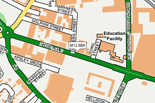
M12 6BH is located in the Ardwick electoral ward, within the metropolitan district of Manchester and the English Parliamentary constituency of Manchester Central. The Sub Integrated Care Board (ICB) Location is NHS Greater Manchester ICB - 14L and the police force is Greater Manchester. This postcode has been in use since January 1980.


GetTheData
Source: OS OpenMap – Local (Ordnance Survey)
Source: OS VectorMap District (Ordnance Survey)
Licence: Open Government Licence (requires attribution)
| Easting | 385617 |
| Northing | 396989 |
| Latitude | 53.469454 |
| Longitude | -2.218136 |
GetTheData
Source: Open Postcode Geo
Licence: Open Government Licence
| Country | England |
| Postcode District | M12 |
➜ See where M12 is on a map ➜ Where is Manchester? | |
GetTheData
Source: Land Registry Price Paid Data
Licence: Open Government Licence
Elevation or altitude of M12 6BH as distance above sea level:
| Metres | Feet | |
|---|---|---|
| Elevation | 50m | 164ft |
Elevation is measured from the approximate centre of the postcode, to the nearest point on an OS contour line from OS Terrain 50, which has contour spacing of ten vertical metres.
➜ How high above sea level am I? Find the elevation of your current position using your device's GPS.
GetTheData
Source: Open Postcode Elevation
Licence: Open Government Licence
| Ward | Ardwick |
| Constituency | Manchester Central |
GetTheData
Source: ONS Postcode Database
Licence: Open Government Licence
| Hyde Rd/Nicholls College (Hyde Rd) | Ardwick | 50m |
| Hyde Rd/Devonshire St (Hyde Rd) | Ardwick | 78m |
| Hyde Rd/Apollo (Hyde Rd) | Ardwick | 178m |
| Hyde Rd/Apollo (Hyde Rd) | Ardwick | 199m |
| Stockport Rd/Ardwick P.o. (Stockport Rd) | Ardwick | 253m |
| Piccadilly (Manchester Metrolink) (London Road) | Manchester City Centre | 1,251m |
| New Islington (Manchester Metrolink) (Pollard Street) | New Islington | 1,298m |
| Piccadilly Gardens (Manchester Metrolink) (Portland Street) | Piccadilly Gardens | 1,699m |
| Market Street (Manchester Metrolink) (Market Street) | Manchester City Centre | 1,968m |
| Ardwick Station | 0.4km |
| Manchester Piccadilly Station | 1.2km |
| Ashburys Station | 1.6km |
GetTheData
Source: NaPTAN
Licence: Open Government Licence
GetTheData
Source: ONS Postcode Database
Licence: Open Government Licence

➜ Get more ratings from the Food Standards Agency
GetTheData
Source: Food Standards Agency
Licence: FSA terms & conditions
| Last Collection | |||
|---|---|---|---|
| Location | Mon-Fri | Sat | Distance |
| Stockport Road P.o. | 18:00 | 12:00 | 247m |
| Devonshire Street South | 17:30 | 12:00 | 453m |
| Brunswich Street | 17:30 | 12:00 | 475m |
GetTheData
Source: Dracos
Licence: Creative Commons Attribution-ShareAlike
| Risk of M12 6BH flooding from rivers and sea | Low |
| ➜ M12 6BH flood map | |
GetTheData
Source: Open Flood Risk by Postcode
Licence: Open Government Licence
The below table lists the International Territorial Level (ITL) codes (formerly Nomenclature of Territorial Units for Statistics (NUTS) codes) and Local Administrative Units (LAU) codes for M12 6BH:
| ITL 1 Code | Name |
|---|---|
| TLD | North West (England) |
| ITL 2 Code | Name |
| TLD3 | Greater Manchester |
| ITL 3 Code | Name |
| TLD33 | Manchester |
| LAU 1 Code | Name |
| E08000003 | Manchester |
GetTheData
Source: ONS Postcode Directory
Licence: Open Government Licence
The below table lists the Census Output Area (OA), Lower Layer Super Output Area (LSOA), and Middle Layer Super Output Area (MSOA) for M12 6BH:
| Code | Name | |
|---|---|---|
| OA | E00025617 | |
| LSOA | E01005065 | Manchester 018D |
| MSOA | E02001062 | Manchester 018 |
GetTheData
Source: ONS Postcode Directory
Licence: Open Government Licence
| M12 6BN | Dalberg Street | 97m |
| M12 6AW | Apsley Grove | 136m |
| M12 6BG | Dolphin Street | 189m |
| M12 6BT | Harkness Street | 225m |
| M13 9DZ | Stockport Road | 276m |
| M12 6AL | Stockport Road | 279m |
| M13 9FL | Jevington Walk | 304m |
| M13 9FX | Polygon Avenue | 311m |
| M13 9BS | Tarleton Street | 321m |
| M12 6DD | Thames Industrial Estate | 328m |
GetTheData
Source: Open Postcode Geo; Land Registry Price Paid Data
Licence: Open Government Licence