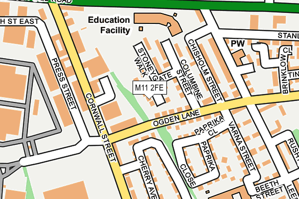
M11 2FE is located in the Clayton & Openshaw electoral ward, within the metropolitan district of Manchester and the English Parliamentary constituency of Manchester Central. The Sub Integrated Care Board (ICB) Location is NHS Greater Manchester ICB - 14L and the police force is Greater Manchester. This postcode has been in use since May 2017.


GetTheData
Source: OS OpenMap – Local (Ordnance Survey)
Source: OS VectorMap District (Ordnance Survey)
Licence: Open Government Licence (requires attribution)
| Easting | 388756 |
| Northing | 397183 |
| Latitude | 53.471275 |
| Longitude | -2.170857 |
GetTheData
Source: Open Postcode Geo
Licence: Open Government Licence
| Country | England |
| Postcode District | M11 |
➜ See where M11 is on a map ➜ Where is Manchester? | |
GetTheData
Source: Land Registry Price Paid Data
Licence: Open Government Licence
| Ward | Clayton & Openshaw |
| Constituency | Manchester Central |
GetTheData
Source: ONS Postcode Database
Licence: Open Government Licence
| Ogden Ln/Cornwall St (Ogden Ln) | Gorton | 81m |
| Ogden Ln/Cornwall St (Ogden Ln) | Gorton | 90m |
| Ashton Old Rd/Louisa St (Ashton Old Rd) | Openshaw | 193m |
| Ashton Old Rd/Lees St (Ashton Old Rd) | Openshaw | 236m |
| Ashton Old Rd/Lees St (Ashton Old Rd) | Openshaw | 249m |
| Edge Lane (Manchester Metrolink) (Manchester Road) | Droylsden | 1,130m |
| Cemetery Road (Manchester Metrolink) (Manchester Road) | Droylsden | 1,421m |
| Clayton Hall (Manchester Metrolink) (Ashton New Road) | Clayton | 1,485m |
| Velopark (Manchester Metrolink) (Ashton New Road) | Sportcity | 1,914m |
| Gorton Station | 0.4km |
| Belle Vue Station | 1.2km |
| Ashburys Station | 1.6km |
GetTheData
Source: NaPTAN
Licence: Open Government Licence
| Percentage of properties with Next Generation Access | 100.0% |
| Percentage of properties with Superfast Broadband | 100.0% |
| Percentage of properties with Ultrafast Broadband | 0.0% |
| Percentage of properties with Full Fibre Broadband | 0.0% |
Superfast Broadband is between 30Mbps and 300Mbps
Ultrafast Broadband is > 300Mbps
| Median download speed | 55.0Mbps |
| Average download speed | 49.0Mbps |
| Maximum download speed | 72.93Mbps |
| Median upload speed | 10.0Mbps |
| Average upload speed | 12.2Mbps |
| Maximum upload speed | 19.81Mbps |
| Percentage of properties unable to receive 2Mbps | 0.0% |
| Percentage of properties unable to receive 5Mbps | 0.0% |
| Percentage of properties unable to receive 10Mbps | 0.0% |
| Percentage of properties unable to receive 30Mbps | 0.0% |
GetTheData
Source: Ofcom
Licence: Ofcom Terms of Use (requires attribution)
GetTheData
Source: ONS Postcode Database
Licence: Open Government Licence


➜ Get more ratings from the Food Standards Agency
GetTheData
Source: Food Standards Agency
Licence: FSA terms & conditions
| Last Collection | |||
|---|---|---|---|
| Location | Mon-Fri | Sat | Distance |
| Station | 17:30 | 12:00 | 295m |
| Victoria Street | 17:30 | 12:00 | 477m |
| 42 Wheeler Street | 17:30 | 12:00 | 529m |
GetTheData
Source: Dracos
Licence: Creative Commons Attribution-ShareAlike
The below table lists the International Territorial Level (ITL) codes (formerly Nomenclature of Territorial Units for Statistics (NUTS) codes) and Local Administrative Units (LAU) codes for M11 2FE:
| ITL 1 Code | Name |
|---|---|
| TLD | North West (England) |
| ITL 2 Code | Name |
| TLD3 | Greater Manchester |
| ITL 3 Code | Name |
| TLD33 | Manchester |
| LAU 1 Code | Name |
| E08000003 | Manchester |
GetTheData
Source: ONS Postcode Directory
Licence: Open Government Licence
The below table lists the Census Output Area (OA), Lower Layer Super Output Area (LSOA), and Middle Layer Super Output Area (MSOA) for M11 2FE:
| Code | Name | |
|---|---|---|
| OA | E00025850 | |
| LSOA | E01005108 | Manchester 017A |
| MSOA | E02001061 | Manchester 017 |
GetTheData
Source: ONS Postcode Directory
Licence: Open Government Licence
| M11 2NT | Dewey Street | 72m |
| M11 2LR | Ogden Lane | 109m |
| M11 2LE | Chisholm Street | 115m |
| M11 2LF | Chisholm Street | 141m |
| M11 2LS | Paprika Close | 153m |
| M11 1WH | Lees Street | 159m |
| M11 2EN | Cornwall Street | 164m |
| M11 2LW | Cherry Avenue | 176m |
| M11 1NG | Ogden Lane | 186m |
| M11 1WP | Varna Street | 205m |
GetTheData
Source: Open Postcode Geo; Land Registry Price Paid Data
Licence: Open Government Licence