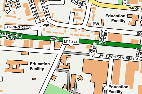
M11 2BZ is located in the Clayton & Openshaw electoral ward, within the metropolitan district of Manchester and the English Parliamentary constituency of Manchester Central. The Sub Integrated Care Board (ICB) Location is NHS Greater Manchester ICB - 14L and the police force is Greater Manchester. This postcode has been in use since December 1994.


GetTheData
Source: OS OpenMap – Local (Ordnance Survey)
Source: OS VectorMap District (Ordnance Survey)
Licence: Open Government Licence (requires attribution)
| Easting | 387536 |
| Northing | 397449 |
| Latitude | 53.473622 |
| Longitude | -2.189248 |
GetTheData
Source: Open Postcode Geo
Licence: Open Government Licence
| Country | England |
| Postcode District | M11 |
➜ See where M11 is on a map ➜ Where is Manchester? | |
GetTheData
Source: Land Registry Price Paid Data
Licence: Open Government Licence
Elevation or altitude of M11 2BZ as distance above sea level:
| Metres | Feet | |
|---|---|---|
| Elevation | 60m | 197ft |
Elevation is measured from the approximate centre of the postcode, to the nearest point on an OS contour line from OS Terrain 50, which has contour spacing of ten vertical metres.
➜ How high above sea level am I? Find the elevation of your current position using your device's GPS.
GetTheData
Source: Open Postcode Elevation
Licence: Open Government Licence
| Ward | Clayton & Openshaw |
| Constituency | Manchester Central |
GetTheData
Source: ONS Postcode Database
Licence: Open Government Licence
| Ashton Old Rd/Clayton Ln Sth (Ashton Old Rd) | Openshaw | 51m |
| Ashton Old Rd/Clayton Ln Sth (Ashton Old Rd) | Openshaw | 61m |
| Ashton Old Rd/Crossley House (Ashton Old Rd) | Openshaw | 166m |
| Ashton Old Rd/Wood St (Ashton Old Rd) | Openshaw | 240m |
| Parkhouse St (Sbnd) (Parkhouse St) | Openshaw | 277m |
| Velopark (Manchester Metrolink) (Ashton New Road) | Sportcity | 993m |
| Clayton Hall (Manchester Metrolink) (Ashton New Road) | Clayton | 1,123m |
| Etihad Campus (Manchester Metrolink) (Joe Mercer Way) | Sportcity | 1,533m |
| Ashburys Station | 0.4km |
| Belle Vue Station | 1.4km |
| Gorton Station | 1.6km |
GetTheData
Source: NaPTAN
Licence: Open Government Licence
GetTheData
Source: ONS Postcode Database
Licence: Open Government Licence


➜ Get more ratings from the Food Standards Agency
GetTheData
Source: Food Standards Agency
Licence: FSA terms & conditions
| Last Collection | |||
|---|---|---|---|
| Location | Mon-Fri | Sat | Distance |
| Openshaw P.o. | 17:30 | 12:00 | 249m |
| Gorton Brook | 17:30 | 12:00 | 575m |
| Greenside Street | 17:30 | 12:00 | 672m |
GetTheData
Source: Dracos
Licence: Creative Commons Attribution-ShareAlike
The below table lists the International Territorial Level (ITL) codes (formerly Nomenclature of Territorial Units for Statistics (NUTS) codes) and Local Administrative Units (LAU) codes for M11 2BZ:
| ITL 1 Code | Name |
|---|---|
| TLD | North West (England) |
| ITL 2 Code | Name |
| TLD3 | Greater Manchester |
| ITL 3 Code | Name |
| TLD33 | Manchester |
| LAU 1 Code | Name |
| E08000003 | Manchester |
GetTheData
Source: ONS Postcode Directory
Licence: Open Government Licence
The below table lists the Census Output Area (OA), Lower Layer Super Output Area (LSOA), and Middle Layer Super Output Area (MSOA) for M11 2BZ:
| Code | Name | |
|---|---|---|
| OA | E00025845 | |
| LSOA | E01005106 | Manchester 015D |
| MSOA | E02001059 | Manchester 015 |
GetTheData
Source: ONS Postcode Directory
Licence: Open Government Licence
| M11 2HD | Ashton Old Road | 54m |
| M11 2EJ | Neden Close | 126m |
| M11 2EF | Herne Street | 155m |
| M11 2BG | Herne Street | 155m |
| M11 2NE | The Dresser Centre | 210m |
| M11 2AN | Mayton Street | 214m |
| M11 2AT | Beede Street | 239m |
| M11 2AJ | Herne Street | 260m |
| M11 2BU | Dulgar Street | 285m |
| M11 2BY | Selby Street | 298m |
GetTheData
Source: Open Postcode Geo; Land Registry Price Paid Data
Licence: Open Government Licence