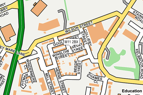
M11 2BX lies on Attewell Street in Openshaw, Manchester. M11 2BX is located in the Clayton & Openshaw electoral ward, within the metropolitan district of Manchester and the English Parliamentary constituency of Manchester Central. The Sub Integrated Care Board (ICB) Location is NHS Greater Manchester ICB - 14L and the police force is Greater Manchester. This postcode has been in use since May 1994.


GetTheData
Source: OS OpenMap – Local (Ordnance Survey)
Source: OS VectorMap District (Ordnance Survey)
Licence: Open Government Licence (requires attribution)
| Easting | 387470 |
| Northing | 397764 |
| Latitude | 53.476452 |
| Longitude | -2.190255 |
GetTheData
Source: Open Postcode Geo
Licence: Open Government Licence
| Street | Attewell Street |
| Locality | Openshaw |
| Town/City | Manchester |
| Country | England |
| Postcode District | M11 |
➜ See where M11 is on a map ➜ Where is Manchester? | |
GetTheData
Source: Land Registry Price Paid Data
Licence: Open Government Licence
Elevation or altitude of M11 2BX as distance above sea level:
| Metres | Feet | |
|---|---|---|
| Elevation | 60m | 197ft |
Elevation is measured from the approximate centre of the postcode, to the nearest point on an OS contour line from OS Terrain 50, which has contour spacing of ten vertical metres.
➜ How high above sea level am I? Find the elevation of your current position using your device's GPS.
GetTheData
Source: Open Postcode Elevation
Licence: Open Government Licence
| Ward | Clayton & Openshaw |
| Constituency | Manchester Central |
GetTheData
Source: ONS Postcode Database
Licence: Open Government Licence
| Parkhouse St (Sbnd) (Parkhouse St) | Openshaw | 126m |
| Alan Turing Way/Wilson St (Alan Turing Way) | Beswick | 210m |
| Alan Turing Way/Grey Mare Ln (Alan Turing Way) | Beswick | 231m |
| Ashton Old Rd/Clayton Ln Sth (Ashton Old Rd) | Openshaw | 288m |
| Ashton Old Rd/Clayton Ln Sth (Ashton Old Rd) | Openshaw | 300m |
| Velopark (Manchester Metrolink) (Ashton New Road) | Sportcity | 672m |
| Clayton Hall (Manchester Metrolink) (Ashton New Road) | Clayton | 886m |
| Etihad Campus (Manchester Metrolink) (Joe Mercer Way) | Sportcity | 1,234m |
| Holt Town (Manchester Metrolink) (Holt Town) | Holt Town | 1,638m |
| Ashburys Station | 0.6km |
| Ardwick Station | 1.7km |
| Belle Vue Station | 1.7km |
GetTheData
Source: NaPTAN
Licence: Open Government Licence
| Percentage of properties with Next Generation Access | 0.0% |
| Percentage of properties with Superfast Broadband | 0.0% |
| Percentage of properties with Ultrafast Broadband | 0.0% |
| Percentage of properties with Full Fibre Broadband | 0.0% |
Superfast Broadband is between 30Mbps and 300Mbps
Ultrafast Broadband is > 300Mbps
| Percentage of properties unable to receive 2Mbps | 0.0% |
| Percentage of properties unable to receive 5Mbps | 0.0% |
| Percentage of properties unable to receive 10Mbps | 0.0% |
| Percentage of properties unable to receive 30Mbps | 100.0% |
GetTheData
Source: Ofcom
Licence: Ofcom Terms of Use (requires attribution)
GetTheData
Source: ONS Postcode Database
Licence: Open Government Licence


➜ Get more ratings from the Food Standards Agency
GetTheData
Source: Food Standards Agency
Licence: FSA terms & conditions
| Last Collection | |||
|---|---|---|---|
| Location | Mon-Fri | Sat | Distance |
| Openshaw P.o. | 17:30 | 12:00 | 147m |
| Greenside Street | 17:30 | 12:00 | 453m |
| Beswick P.o. | 17:30 | 12:00 | 494m |
GetTheData
Source: Dracos
Licence: Creative Commons Attribution-ShareAlike
The below table lists the International Territorial Level (ITL) codes (formerly Nomenclature of Territorial Units for Statistics (NUTS) codes) and Local Administrative Units (LAU) codes for M11 2BX:
| ITL 1 Code | Name |
|---|---|
| TLD | North West (England) |
| ITL 2 Code | Name |
| TLD3 | Greater Manchester |
| ITL 3 Code | Name |
| TLD33 | Manchester |
| LAU 1 Code | Name |
| E08000003 | Manchester |
GetTheData
Source: ONS Postcode Directory
Licence: Open Government Licence
The below table lists the Census Output Area (OA), Lower Layer Super Output Area (LSOA), and Middle Layer Super Output Area (MSOA) for M11 2BX:
| Code | Name | |
|---|---|---|
| OA | E00025836 | |
| LSOA | E01005106 | Manchester 015D |
| MSOA | E02001059 | Manchester 015 |
GetTheData
Source: ONS Postcode Directory
Licence: Open Government Licence
| M11 2AX | Goole Street | 30m |
| M11 2BY | Selby Street | 31m |
| M11 2AY | Winslow Street | 49m |
| M11 2AU | Goole Street | 49m |
| M11 2BU | Dulgar Street | 54m |
| M11 2AW | Colliery Street | 55m |
| M11 2AZ | Wilson Street | 63m |
| M11 2AP | Colliery Street | 75m |
| M11 2AT | Beede Street | 82m |
| M11 2AJ | Herne Street | 96m |
GetTheData
Source: Open Postcode Geo; Land Registry Price Paid Data
Licence: Open Government Licence