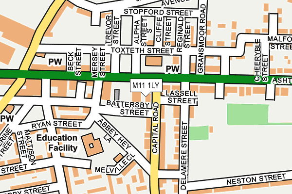
M11 1LY lies on Battersby Street in Manchester. M11 1LY is located in the Clayton & Openshaw electoral ward, within the metropolitan district of Manchester and the English Parliamentary constituency of Manchester Central. The Sub Integrated Care Board (ICB) Location is NHS Greater Manchester ICB - 14L and the police force is Greater Manchester. This postcode has been in use since February 2008.


GetTheData
Source: OS OpenMap – Local (Ordnance Survey)
Source: OS VectorMap District (Ordnance Survey)
Licence: Open Government Licence (requires attribution)
| Easting | 389462 |
| Northing | 397270 |
| Latitude | 53.472072 |
| Longitude | -2.160224 |
GetTheData
Source: Open Postcode Geo
Licence: Open Government Licence
| Street | Battersby Street |
| Town/City | Manchester |
| Country | England |
| Postcode District | M11 |
➜ See where M11 is on a map ➜ Where is Manchester? | |
GetTheData
Source: Land Registry Price Paid Data
Licence: Open Government Licence
Elevation or altitude of M11 1LY as distance above sea level:
| Metres | Feet | |
|---|---|---|
| Elevation | 80m | 262ft |
Elevation is measured from the approximate centre of the postcode, to the nearest point on an OS contour line from OS Terrain 50, which has contour spacing of ten vertical metres.
➜ How high above sea level am I? Find the elevation of your current position using your device's GPS.
GetTheData
Source: Open Postcode Elevation
Licence: Open Government Licence
| Ward | Clayton & Openshaw |
| Constituency | Manchester Central |
GetTheData
Source: ONS Postcode Database
Licence: Open Government Licence
| Capital Rd/Ashton Old Rd (Capital Rd) | Higher Openshaw | 51m |
| Capital Rd/Ashton Old Rd (Capital Rd) | Higher Openshaw | 79m |
| Abbey Hey Ln/Melville Cl (Abbey Hey Ln) | Higher Openshaw | 86m |
| Ashton Old Rd/Gransmoor Rd (Ashton Old Rd) | Higher Openshaw | 140m |
| Ashton Old Rd/Fairfield Rd (Ashton Old Rd) | Higher Openshaw | 158m |
| Cemetery Road (Manchester Metrolink) (Manchester Road) | Droylsden | 933m |
| Edge Lane (Manchester Metrolink) (Manchester Road) | Droylsden | 1,033m |
| Droylsden (Manchester Metrolink) (Ashton Road) | Droylsden | 1,319m |
| Clayton Hall (Manchester Metrolink) (Ashton New Road) | Clayton | 1,883m |
| Gorton Station | 0.5km |
| Fairfield Station | 1km |
| Belle Vue Station | 1.7km |
GetTheData
Source: NaPTAN
Licence: Open Government Licence
GetTheData
Source: ONS Postcode Database
Licence: Open Government Licence


➜ Get more ratings from the Food Standards Agency
GetTheData
Source: Food Standards Agency
Licence: FSA terms & conditions
| Last Collection | |||
|---|---|---|---|
| Location | Mon-Fri | Sat | Distance |
| Gransmoor Road | 17:30 | 12:00 | 163m |
| Higher Openshaw | 17:30 | 12:00 | 197m |
| Abbey Hey P.o. | 17:30 | 12:00 | 371m |
GetTheData
Source: Dracos
Licence: Creative Commons Attribution-ShareAlike
The below table lists the International Territorial Level (ITL) codes (formerly Nomenclature of Territorial Units for Statistics (NUTS) codes) and Local Administrative Units (LAU) codes for M11 1LY:
| ITL 1 Code | Name |
|---|---|
| TLD | North West (England) |
| ITL 2 Code | Name |
| TLD3 | Greater Manchester |
| ITL 3 Code | Name |
| TLD33 | Manchester |
| LAU 1 Code | Name |
| E08000003 | Manchester |
GetTheData
Source: ONS Postcode Directory
Licence: Open Government Licence
The below table lists the Census Output Area (OA), Lower Layer Super Output Area (LSOA), and Middle Layer Super Output Area (MSOA) for M11 1LY:
| Code | Name | |
|---|---|---|
| OA | E00025852 | |
| LSOA | E01033666 | Manchester 017F |
| MSOA | E02001061 | Manchester 017 |
GetTheData
Source: ONS Postcode Directory
Licence: Open Government Licence
| M11 1LA | Capital Road | 51m |
| M11 1JU | Ashton Old Road | 64m |
| M11 1JZ | Capital Road | 71m |
| M11 1JX | Ashton Old Road | 99m |
| M11 1JY | Delamere Street | 103m |
| M11 1JT | Ashton Old Road | 121m |
| M11 1LT | Ryan Street | 125m |
| M11 1JR | Holmpark Road | 132m |
| M11 1JG | Ashton Old Road | 133m |
| M11 1LE | Stanley Street | 141m |
GetTheData
Source: Open Postcode Geo; Land Registry Price Paid Data
Licence: Open Government Licence