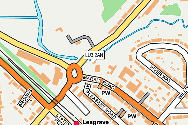
LU3 2AN lies on Bramingham Road in Luton. LU3 2AN is located in the Northwell electoral ward, within the unitary authority of Luton and the English Parliamentary constituency of Luton North. The Sub Integrated Care Board (ICB) Location is NHS Bedfordshire, Luton and Milton Keynes ICB - M1J4Y and the police force is Bedfordshire. This postcode has been in use since September 2005.


GetTheData
Source: OS OpenMap – Local (Ordnance Survey)
Source: OS VectorMap District (Ordnance Survey)
Licence: Open Government Licence (requires attribution)
| Easting | 506196 |
| Northing | 224300 |
| Latitude | 51.907125 |
| Longitude | -0.457694 |
GetTheData
Source: Open Postcode Geo
Licence: Open Government Licence
| Street | Bramingham Road |
| Town/City | Luton |
| Country | England |
| Postcode District | LU3 |
➜ See where LU3 is on a map ➜ Where is Luton? | |
GetTheData
Source: Land Registry Price Paid Data
Licence: Open Government Licence
Elevation or altitude of LU3 2AN as distance above sea level:
| Metres | Feet | |
|---|---|---|
| Elevation | 120m | 394ft |
Elevation is measured from the approximate centre of the postcode, to the nearest point on an OS contour line from OS Terrain 50, which has contour spacing of ten vertical metres.
➜ How high above sea level am I? Find the elevation of your current position using your device's GPS.
GetTheData
Source: Open Postcode Elevation
Licence: Open Government Licence
| Ward | Northwell |
| Constituency | Luton North |
GetTheData
Source: ONS Postcode Database
Licence: Open Government Licence
| Leagrave Railway Station (Marsh Road) | Leagrave | 51m |
| Leagrave Railway Station (Bramingham Road) | Leagrave | 75m |
| Leagrave Railway Station (Grange Avenue) | Leagrave | 94m |
| Leagrave Railway Station (Sundon Park Road) | Leagrave | 160m |
| Browns Close (Toddington Road) | Leagrave | 254m |
| Leagrave Station | 0.2km |
| Luton Station | 4.1km |
| Luton Airport Parkway Station | 5.7km |
GetTheData
Source: NaPTAN
Licence: Open Government Licence
GetTheData
Source: ONS Postcode Database
Licence: Open Government Licence


➜ Get more ratings from the Food Standards Agency
GetTheData
Source: Food Standards Agency
Licence: FSA terms & conditions
| Last Collection | |||
|---|---|---|---|
| Location | Mon-Fri | Sat | Distance |
| Leagrave Station | 18:30 | 12:00 | 230m |
| Willow Way | 18:30 | 12:30 | 298m |
| Nappsbury Road | 17:30 | 12:15 | 442m |
GetTheData
Source: Dracos
Licence: Creative Commons Attribution-ShareAlike
| Risk of LU3 2AN flooding from rivers and sea | Low |
| ➜ LU3 2AN flood map | |
GetTheData
Source: Open Flood Risk by Postcode
Licence: Open Government Licence
The below table lists the International Territorial Level (ITL) codes (formerly Nomenclature of Territorial Units for Statistics (NUTS) codes) and Local Administrative Units (LAU) codes for LU3 2AN:
| ITL 1 Code | Name |
|---|---|
| TLH | East |
| ITL 2 Code | Name |
| TLH2 | Bedfordshire and Hertfordshire |
| ITL 3 Code | Name |
| TLH21 | Luton |
| LAU 1 Code | Name |
| E06000032 | Luton |
GetTheData
Source: ONS Postcode Directory
Licence: Open Government Licence
The below table lists the Census Output Area (OA), Lower Layer Super Output Area (LSOA), and Middle Layer Super Output Area (MSOA) for LU3 2AN:
| Code | Name | |
|---|---|---|
| OA | E00079709 | |
| LSOA | E01015765 | Luton 006B |
| MSOA | E02003263 | Luton 006 |
GetTheData
Source: ONS Postcode Directory
Licence: Open Government Licence
| LU3 2RB | Marsh Road | 59m |
| LU3 2RX | Marsh Road | 144m |
| LU3 2RL | Mount Pleasant Road | 164m |
| LU3 2RT | Marsh Road | 167m |
| LU3 2RR | Mount Pleasant Road | 188m |
| LU3 2SL | Bramingham Road | 194m |
| LU3 2SE | River Way | 195m |
| LU3 2ST | The Stepping Stones | 209m |
| LU4 9AA | Toddington Road | 250m |
| LU3 2RU | Marsh Road | 256m |
GetTheData
Source: Open Postcode Geo; Land Registry Price Paid Data
Licence: Open Government Licence