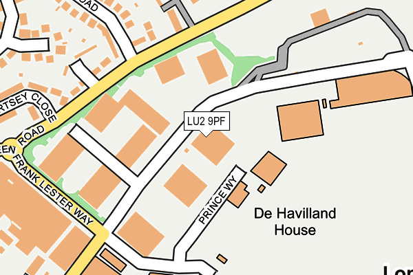
LU2 9PF is located in the Wigmore electoral ward, within the unitary authority of Luton and the English Parliamentary constituency of Luton South. The Sub Integrated Care Board (ICB) Location is NHS Bedfordshire, Luton and Milton Keynes ICB - M1J4Y and the police force is Bedfordshire. This postcode has been in use since June 1981.


GetTheData
Source: OS OpenMap – Local (Ordnance Survey)
Source: OS VectorMap District (Ordnance Survey)
Licence: Open Government Licence (requires attribution)
| Easting | 511816 |
| Northing | 221860 |
| Latitude | 51.884098 |
| Longitude | -0.376824 |
GetTheData
Source: Open Postcode Geo
Licence: Open Government Licence
| Country | England |
| Postcode District | LU2 |
➜ See where LU2 is on a map | |
GetTheData
Source: Land Registry Price Paid Data
Licence: Open Government Licence
Elevation or altitude of LU2 9PF as distance above sea level:
| Metres | Feet | |
|---|---|---|
| Elevation | 150m | 492ft |
Elevation is measured from the approximate centre of the postcode, to the nearest point on an OS contour line from OS Terrain 50, which has contour spacing of ten vertical metres.
➜ How high above sea level am I? Find the elevation of your current position using your device's GPS.
GetTheData
Source: Open Postcode Elevation
Licence: Open Government Licence
| Ward | Wigmore |
| Constituency | Luton South |
GetTheData
Source: ONS Postcode Database
Licence: Open Government Licence
| Airport Executive Park (President Way) | Luton Airport | 39m |
| Airport Executive Park (President Way) | Luton Airport | 85m |
| Airport Executive Park (President Way) | Luton Airport | 133m |
| Hartop Court (Eaton Green Road) | Vauxhall Park | 173m |
| Chertsey Close (Crawley Green Road) | Vauxhall Park | 186m |
| Luton Airport Parkway Station | 1.8km |
| Luton Station | 2.6km |
GetTheData
Source: NaPTAN
Licence: Open Government Licence
GetTheData
Source: ONS Postcode Database
Licence: Open Government Licence


➜ Get more ratings from the Food Standards Agency
GetTheData
Source: Food Standards Agency
Licence: FSA terms & conditions
| Last Collection | |||
|---|---|---|---|
| Location | Mon-Fri | Sat | Distance |
| Chertsey Close | 17:30 | 12:15 | 221m |
| Airport Approach | 18:30 | 237m | |
| Raynham Way | 17:30 | 12:00 | 488m |
GetTheData
Source: Dracos
Licence: Creative Commons Attribution-ShareAlike
The below table lists the International Territorial Level (ITL) codes (formerly Nomenclature of Territorial Units for Statistics (NUTS) codes) and Local Administrative Units (LAU) codes for LU2 9PF:
| ITL 1 Code | Name |
|---|---|
| TLH | East |
| ITL 2 Code | Name |
| TLH2 | Bedfordshire and Hertfordshire |
| ITL 3 Code | Name |
| TLH21 | Luton |
| LAU 1 Code | Name |
| E06000032 | Luton |
GetTheData
Source: ONS Postcode Directory
Licence: Open Government Licence
The below table lists the Census Output Area (OA), Lower Layer Super Output Area (LSOA), and Middle Layer Super Output Area (MSOA) for LU2 9PF:
| Code | Name | |
|---|---|---|
| OA | E00079923 | |
| LSOA | E01015811 | Luton 014G |
| MSOA | E02003271 | Luton 014 |
GetTheData
Source: ONS Postcode Directory
Licence: Open Government Licence
| LU2 9PD | Prince Way | 29m |
| LU2 9LB | Eaton Place | 179m |
| LU2 9JF | Lalleford Road | 183m |
| LU2 9JE | Eaton Green Road | 185m |
| LU2 9JG | Lalleford Road | 257m |
| LU2 9HJ | Gresham Close | 270m |
| LU2 9JD | Chertsey Close | 282m |
| LU2 9RZ | Barnston Close | 293m |
| LU2 9JL | Barrowby Close | 309m |
| LU2 9SU | Chelsworth Close | 340m |
GetTheData
Source: Open Postcode Geo; Land Registry Price Paid Data
Licence: Open Government Licence