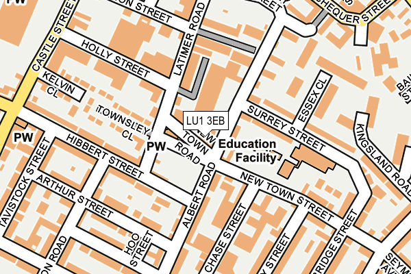
LU1 3EB lies on New Town Street in Luton. LU1 3EB is located in the South electoral ward, within the unitary authority of Luton and the English Parliamentary constituency of Luton South. The Sub Integrated Care Board (ICB) Location is NHS Bedfordshire, Luton and Milton Keynes ICB - M1J4Y and the police force is Bedfordshire. This postcode has been in use since January 1983.


GetTheData
Source: OS OpenMap – Local (Ordnance Survey)
Source: OS VectorMap District (Ordnance Survey)
Licence: Open Government Licence (requires attribution)
| Easting | 509359 |
| Northing | 220641 |
| Latitude | 51.873637 |
| Longitude | -0.412868 |
GetTheData
Source: Open Postcode Geo
Licence: Open Government Licence
| Street | New Town Street |
| Town/City | Luton |
| Country | England |
| Postcode District | LU1 |
➜ See where LU1 is on a map ➜ Where is Luton? | |
GetTheData
Source: Land Registry Price Paid Data
Licence: Open Government Licence
Elevation or altitude of LU1 3EB as distance above sea level:
| Metres | Feet | |
|---|---|---|
| Elevation | 120m | 394ft |
Elevation is measured from the approximate centre of the postcode, to the nearest point on an OS contour line from OS Terrain 50, which has contour spacing of ten vertical metres.
➜ How high above sea level am I? Find the elevation of your current position using your device's GPS.
GetTheData
Source: Open Postcode Elevation
Licence: Open Government Licence
| Ward | South |
| Constituency | Luton South |
GetTheData
Source: ONS Postcode Database
Licence: Open Government Licence
77 - 79, NEW TOWN STREET, LUTON, LU1 3EB 2002 13 SEP £160,000 |
GetTheData
Source: HM Land Registry Price Paid Data
Licence: Contains HM Land Registry data © Crown copyright and database right 2025. This data is licensed under the Open Government Licence v3.0.
| Latimer Road | Park Town | 121m |
| Arthur Street (Albert Road) | New Town | 182m |
| Holly Street (Castle Street) | New Town | 278m |
| Holly Street (Castle Street) | New Town | 291m |
| Bailey Street (Park Street) | Park Town | 362m |
| Luton Station | 1km |
| Luton Airport Parkway Station | 1.2km |
| Leagrave Station | 4.7km |
GetTheData
Source: NaPTAN
Licence: Open Government Licence
GetTheData
Source: ONS Postcode Database
Licence: Open Government Licence


➜ Get more ratings from the Food Standards Agency
GetTheData
Source: Food Standards Agency
Licence: FSA terms & conditions
| Last Collection | |||
|---|---|---|---|
| Location | Mon-Fri | Sat | Distance |
| Dorset Court | 17:30 | 12:00 | 223m |
| Tennyson Road | 17:30 | 12:00 | 255m |
| Castle Street | 17:30 | 12:00 | 291m |
GetTheData
Source: Dracos
Licence: Creative Commons Attribution-ShareAlike
The below table lists the International Territorial Level (ITL) codes (formerly Nomenclature of Territorial Units for Statistics (NUTS) codes) and Local Administrative Units (LAU) codes for LU1 3EB:
| ITL 1 Code | Name |
|---|---|
| TLH | East |
| ITL 2 Code | Name |
| TLH2 | Bedfordshire and Hertfordshire |
| ITL 3 Code | Name |
| TLH21 | Luton |
| LAU 1 Code | Name |
| E06000032 | Luton |
GetTheData
Source: ONS Postcode Directory
Licence: Open Government Licence
The below table lists the Census Output Area (OA), Lower Layer Super Output Area (LSOA), and Middle Layer Super Output Area (MSOA) for LU1 3EB:
| Code | Name | |
|---|---|---|
| OA | E00079814 | |
| LSOA | E01015791 | Luton 021C |
| MSOA | E02003278 | Luton 021 |
GetTheData
Source: ONS Postcode Directory
Licence: Open Government Licence
| LU1 3PS | Albert Road | 40m |
| LU1 3BZ | Surrey Street | 93m |
| LU1 3XQ | Langley Terrace Industrial Park | 99m |
| LU1 3XH | Hibbert Street | 105m |
| LU1 3PF | The Foundry | 117m |
| LU1 3UX | Hibbert Street | 126m |
| LU1 3QZ | Chase Street | 142m |
| LU1 3BX | Surrey Street | 144m |
| LU1 3ED | New Town Street | 147m |
| LU1 3PT | Albert Road | 150m |
GetTheData
Source: Open Postcode Geo; Land Registry Price Paid Data
Licence: Open Government Licence