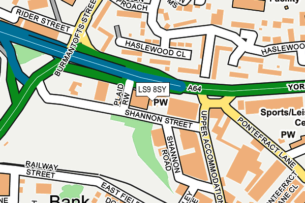
LS9 8SY lies on York Road in Leeds. LS9 8SY is located in the Burmantofts & Richmond Hill electoral ward, within the metropolitan district of Leeds and the English Parliamentary constituency of Leeds Central. The Sub Integrated Care Board (ICB) Location is NHS West Yorkshire ICB - 15F and the police force is West Yorkshire. This postcode has been in use since January 1980.


GetTheData
Source: OS OpenMap – Local (Ordnance Survey)
Source: OS VectorMap District (Ordnance Survey)
Licence: Open Government Licence (requires attribution)
| Easting | 431413 |
| Northing | 433595 |
| Latitude | 53.797734 |
| Longitude | -1.524581 |
GetTheData
Source: Open Postcode Geo
Licence: Open Government Licence
| Street | York Road |
| Town/City | Leeds |
| Country | England |
| Postcode District | LS9 |
➜ See where LS9 is on a map ➜ Where is Leeds? | |
GetTheData
Source: Land Registry Price Paid Data
Licence: Open Government Licence
Elevation or altitude of LS9 8SY as distance above sea level:
| Metres | Feet | |
|---|---|---|
| Elevation | 40m | 131ft |
Elevation is measured from the approximate centre of the postcode, to the nearest point on an OS contour line from OS Terrain 50, which has contour spacing of ten vertical metres.
➜ How high above sea level am I? Find the elevation of your current position using your device's GPS.
GetTheData
Source: Open Postcode Elevation
Licence: Open Government Licence
| Ward | Burmantofts & Richmond Hill |
| Constituency | Leeds Central |
GetTheData
Source: ONS Postcode Database
Licence: Open Government Licence
34, YORK ROAD, LEEDS, LS9 8SY 2005 8 DEC £150,000 |
GetTheData
Source: HM Land Registry Price Paid Data
Licence: Contains HM Land Registry data © Crown copyright and database right 2025. This data is licensed under the Open Government Licence v3.0.
| York Rd Burmantofts Street (York Road) | Richmond Hill | 114m |
| York Rd Pontefract Lane (York Road) | Richmond Hill | 133m |
| York Rd Pontefract Lane (York Road) | Richmond Hill | 158m |
| York Rd Marsh Lane (York Road) | Richmond Hill | 170m |
| Burmantofts Street Rigton Approach (Burmantofts Street) | Burmantofts | 269m |
| Leeds Station | 1.6km |
| Burley Park Station | 3.8km |
| Cross Gates Station | 4.9km |
GetTheData
Source: NaPTAN
Licence: Open Government Licence
GetTheData
Source: ONS Postcode Database
Licence: Open Government Licence


➜ Get more ratings from the Food Standards Agency
GetTheData
Source: Food Standards Agency
Licence: FSA terms & conditions
| Last Collection | |||
|---|---|---|---|
| Location | Mon-Fri | Sat | Distance |
| 29 Upper Accommodation Road | 17:30 | 11:15 | 453m |
| Gargrave Approach | 18:00 | 11:00 | 491m |
| Lincoln Green P.o. | 17:45 | 12:00 | 527m |
GetTheData
Source: Dracos
Licence: Creative Commons Attribution-ShareAlike
The below table lists the International Territorial Level (ITL) codes (formerly Nomenclature of Territorial Units for Statistics (NUTS) codes) and Local Administrative Units (LAU) codes for LS9 8SY:
| ITL 1 Code | Name |
|---|---|
| TLE | Yorkshire and The Humber |
| ITL 2 Code | Name |
| TLE4 | West Yorkshire |
| ITL 3 Code | Name |
| TLE42 | Leeds |
| LAU 1 Code | Name |
| E08000035 | Leeds |
GetTheData
Source: ONS Postcode Directory
Licence: Open Government Licence
The below table lists the Census Output Area (OA), Lower Layer Super Output Area (LSOA), and Middle Layer Super Output Area (MSOA) for LS9 8SY:
| Code | Name | |
|---|---|---|
| OA | E00170044 | |
| LSOA | E01033021 | Leeds 075E |
| MSOA | E02002404 | Leeds 075 |
GetTheData
Source: ONS Postcode Directory
Licence: Open Government Licence
| LS9 7PT | Haslewood Drive | 125m |
| LS9 7PU | Haslewood Close | 127m |
| LS9 9AA | York Road | 194m |
| LS9 7PS | Haslewood Drive | 194m |
| LS9 9AE | Pontefract Lane | 218m |
| LS9 7PN | Haslewood Court | 244m |
| LS9 8PD | Cross Catherine Street | 291m |
| LS9 8FD | The Avenue | 296m |
| LS9 8JB | Lavender Walk | 299m |
| LS9 8FE | The Avenue | 311m |
GetTheData
Source: Open Postcode Geo; Land Registry Price Paid Data
Licence: Open Government Licence