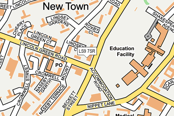
LS9 7SR is located in the Burmantofts & Richmond Hill electoral ward, within the metropolitan district of Leeds and the English Parliamentary constituency of Leeds Central. The Sub Integrated Care Board (ICB) Location is NHS West Yorkshire ICB - 15F and the police force is West Yorkshire. This postcode has been in use since January 1980.


GetTheData
Source: OS OpenMap – Local (Ordnance Survey)
Source: OS VectorMap District (Ordnance Survey)
Licence: Open Government Licence (requires attribution)
| Easting | 431404 |
| Northing | 434120 |
| Latitude | 53.802438 |
| Longitude | -1.524661 |
GetTheData
Source: Open Postcode Geo
Licence: Open Government Licence
| Country | England |
| Postcode District | LS9 |
➜ See where LS9 is on a map ➜ Where is Leeds? | |
GetTheData
Source: Land Registry Price Paid Data
Licence: Open Government Licence
Elevation or altitude of LS9 7SR as distance above sea level:
| Metres | Feet | |
|---|---|---|
| Elevation | 40m | 131ft |
Elevation is measured from the approximate centre of the postcode, to the nearest point on an OS contour line from OS Terrain 50, which has contour spacing of ten vertical metres.
➜ How high above sea level am I? Find the elevation of your current position using your device's GPS.
GetTheData
Source: Open Postcode Elevation
Licence: Open Government Licence
| Ward | Burmantofts & Richmond Hill |
| Constituency | Leeds Central |
GetTheData
Source: ONS Postcode Database
Licence: Open Government Licence
| Lincoln Green Rd Lindsey Road (Lincoln Green Road) | Burmantofts | 43m |
| Beckett St Primary School (Beckett Street) | Burmantofts | 54m |
| Beckett St Primary School (Beckett Street) | Burmantofts | 125m |
| Nippet Lane Beckett St (Nippet Lane) | Burmantofts | 166m |
| Burmantofts Street Nippet Ln (Burmantofts Street) | Burmantofts | 195m |
| Leeds Station | 1.7km |
| Burley Park Station | 3.7km |
| Cross Gates Station | 4.8km |
GetTheData
Source: NaPTAN
Licence: Open Government Licence
Estimated total energy consumption in LS9 7SR by fuel type, 2015.
| Consumption (kWh) | 115,637 |
|---|---|
| Meter count | 10 |
| Mean (kWh/meter) | 11,564 |
| Median (kWh/meter) | 8,533 |
GetTheData
Source: Postcode level gas estimates: 2015 (experimental)
Source: Postcode level electricity estimates: 2015 (experimental)
Licence: Open Government Licence
GetTheData
Source: ONS Postcode Database
Licence: Open Government Licence


➜ Get more ratings from the Food Standards Agency
GetTheData
Source: Food Standards Agency
Licence: FSA terms & conditions
| Last Collection | |||
|---|---|---|---|
| Location | Mon-Fri | Sat | Distance |
| Lincoln Green P.o. | 17:45 | 12:00 | 81m |
| Beckett Street | 17:45 | 11:00 | 243m |
| Cherry Row/Lincoln Road | 18:00 | 11:15 | 297m |
GetTheData
Source: Dracos
Licence: Creative Commons Attribution-ShareAlike
The below table lists the International Territorial Level (ITL) codes (formerly Nomenclature of Territorial Units for Statistics (NUTS) codes) and Local Administrative Units (LAU) codes for LS9 7SR:
| ITL 1 Code | Name |
|---|---|
| TLE | Yorkshire and The Humber |
| ITL 2 Code | Name |
| TLE4 | West Yorkshire |
| ITL 3 Code | Name |
| TLE42 | Leeds |
| LAU 1 Code | Name |
| E08000035 | Leeds |
GetTheData
Source: ONS Postcode Directory
Licence: Open Government Licence
The below table lists the Census Output Area (OA), Lower Layer Super Output Area (LSOA), and Middle Layer Super Output Area (MSOA) for LS9 7SR:
| Code | Name | |
|---|---|---|
| OA | E00058816 | |
| LSOA | E01033035 | Leeds 064F |
| MSOA | E02002393 | Leeds 064 |
GetTheData
Source: ONS Postcode Directory
Licence: Open Government Licence
| LS9 7SZ | Lindsey Court | 34m |
| LS9 7LS | Beckett Street | 38m |
| LS9 7LT | Lindsey Road | 64m |
| LS9 7SU | Lincoln Green Road | 106m |
| LS9 7ST | Cromwell Mount | 162m |
| LS9 7SY | Naseby Walk | 164m |
| LS9 7SX | Naseby Gardens | 183m |
| LS9 7TW | Naseby Place | 221m |
| LS9 7SG | Cromwell Street | 241m |
| LS9 7LW | Granville Road | 241m |
GetTheData
Source: Open Postcode Geo; Land Registry Price Paid Data
Licence: Open Government Licence