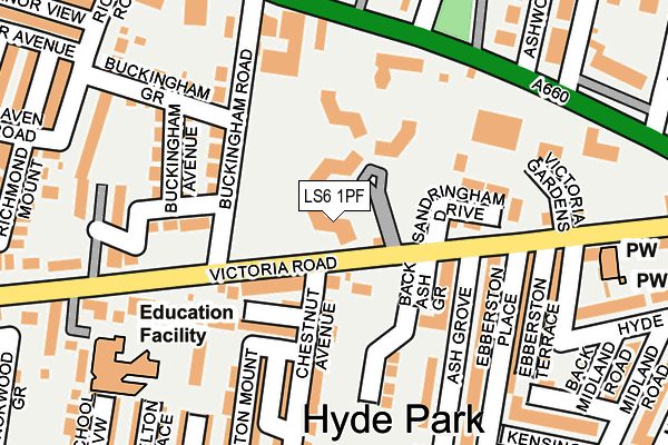
LS6 1PF lies on Victoria Road in Leeds. LS6 1PF is located in the Headingley & Hyde Park electoral ward, within the metropolitan district of Leeds and the English Parliamentary constituency of Leeds North West. The Sub Integrated Care Board (ICB) Location is NHS West Yorkshire ICB - 15F and the police force is West Yorkshire. This postcode has been in use since January 2006.


GetTheData
Source: OS OpenMap – Local (Ordnance Survey)
Source: OS VectorMap District (Ordnance Survey)
Licence: Open Government Licence (requires attribution)
| Easting | 428510 |
| Northing | 435496 |
| Latitude | 53.814971 |
| Longitude | -1.568473 |
GetTheData
Source: Open Postcode Geo
Licence: Open Government Licence
| Street | Victoria Road |
| Town/City | Leeds |
| Country | England |
| Postcode District | LS6 |
➜ See where LS6 is on a map ➜ Where is Leeds? | |
GetTheData
Source: Land Registry Price Paid Data
Licence: Open Government Licence
Elevation or altitude of LS6 1PF as distance above sea level:
| Metres | Feet | |
|---|---|---|
| Elevation | 80m | 262ft |
Elevation is measured from the approximate centre of the postcode, to the nearest point on an OS contour line from OS Terrain 50, which has contour spacing of ten vertical metres.
➜ How high above sea level am I? Find the elevation of your current position using your device's GPS.
GetTheData
Source: Open Postcode Elevation
Licence: Open Government Licence
| Ward | Headingley & Hyde Park |
| Constituency | Leeds North West |
GetTheData
Source: ONS Postcode Database
Licence: Open Government Licence
| Victoria Rd Buckingham Road (Victoria Road) | Hyde Park | 76m |
| Headingley Ln North Hill Road (Headingley Lane) | Hyde Park Corner | 177m |
| Headingley Lane North Grange Rd (Headingley Lane) | Headingley | 196m |
| Headingley Ln North Grange Road (Headingley Lane) | Headingley | 201m |
| Victoria Rd Buckingham Road (Victoria Road) | Hyde Park | 203m |
| Burley Park Station | 0.7km |
| Headingley Station | 1.7km |
| Leeds Station | 2.5km |
GetTheData
Source: NaPTAN
Licence: Open Government Licence
GetTheData
Source: ONS Postcode Database
Licence: Open Government Licence


➜ Get more ratings from the Food Standards Agency
GetTheData
Source: Food Standards Agency
Licence: FSA terms & conditions
| Last Collection | |||
|---|---|---|---|
| Location | Mon-Fri | Sat | Distance |
| Ash Grove/61 Victoria Road | 17:30 | 11:15 | 101m |
| North Hill Road | 17:30 | 12:30 | 194m |
| Brudenell Road P.o. | 17:30 | 12:00 | 333m |
GetTheData
Source: Dracos
Licence: Creative Commons Attribution-ShareAlike
The below table lists the International Territorial Level (ITL) codes (formerly Nomenclature of Territorial Units for Statistics (NUTS) codes) and Local Administrative Units (LAU) codes for LS6 1PF:
| ITL 1 Code | Name |
|---|---|
| TLE | Yorkshire and The Humber |
| ITL 2 Code | Name |
| TLE4 | West Yorkshire |
| ITL 3 Code | Name |
| TLE42 | Leeds |
| LAU 1 Code | Name |
| E08000035 | Leeds |
GetTheData
Source: ONS Postcode Directory
Licence: Open Government Licence
The below table lists the Census Output Area (OA), Lower Layer Super Output Area (LSOA), and Middle Layer Super Output Area (MSOA) for LS6 1PF:
| Code | Name | |
|---|---|---|
| OA | E00057645 | |
| LSOA | E01011443 | Leeds 110B |
| MSOA | E02006861 | Leeds 110 |
GetTheData
Source: ONS Postcode Directory
Licence: Open Government Licence
| LS6 1BB | Chestnut Grove | 116m |
| LS6 1BP | Buckingham Road | 135m |
| LS6 1DH | Buckingham Drive | 144m |
| LS6 1DJ | Buckingham Avenue | 147m |
| LS6 1AY | Ash Grove | 154m |
| LS6 1BA | Chestnut Avenue | 166m |
| LS6 1DR | Victoria Road | 167m |
| LS6 1AZ | Chestnut Avenue | 168m |
| LS6 1BL | Headingley Lane | 182m |
| LS6 1AX | Ash Grove | 185m |
GetTheData
Source: Open Postcode Geo; Land Registry Price Paid Data
Licence: Open Government Licence