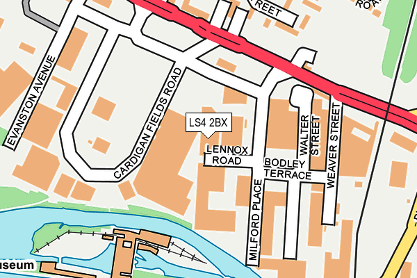
LS4 2BX is located in the Kirkstall electoral ward, within the metropolitan district of Leeds and the English Parliamentary constituency of Leeds West. The Sub Integrated Care Board (ICB) Location is NHS West Yorkshire ICB - 15F and the police force is West Yorkshire. This postcode has been in use since April 2019.


GetTheData
Source: OS OpenMap – Local (Ordnance Survey)
Source: OS VectorMap District (Ordnance Survey)
Licence: Open Government Licence (requires attribution)
| Easting | 427692 |
| Northing | 434320 |
| Latitude | 53.804461 |
| Longitude | -1.581006 |
GetTheData
Source: Open Postcode Geo
Licence: Open Government Licence
| Country | England |
| Postcode District | LS4 |
➜ See where LS4 is on a map ➜ Where is Leeds? | |
GetTheData
Source: Land Registry Price Paid Data
Licence: Open Government Licence
Elevation or altitude of LS4 2BX as distance above sea level:
| Metres | Feet | |
|---|---|---|
| Elevation | 30m | 98ft |
Elevation is measured from the approximate centre of the postcode, to the nearest point on an OS contour line from OS Terrain 50, which has contour spacing of ten vertical metres.
➜ How high above sea level am I? Find the elevation of your current position using your device's GPS.
GetTheData
Source: Open Postcode Elevation
Licence: Open Government Licence
| Ward | Kirkstall |
| Constituency | Leeds West |
GetTheData
Source: ONS Postcode Database
Licence: Open Government Licence
| Kirkstall Rd Wolseley Road (Kirkstall Road) | Burley | 154m |
| Kirkstall Road Cardigan Fields (Kirkstall Road) | Burley | 168m |
| Kirkstall Rd Haddon Road (Kirkstall Road) | Burley | 264m |
| Kirkstall Road Burley Place (Kirkstall Road) | Hyde Park | 279m |
| Burley Place Viaduct Rd (Burley Place) | Hyde Park | 303m |
| Burley Park Station | 0.9km |
| Headingley Station | 1.7km |
| Leeds Station | 2.4km |
GetTheData
Source: NaPTAN
Licence: Open Government Licence
GetTheData
Source: ONS Postcode Database
Licence: Open Government Licence


➜ Get more ratings from the Food Standards Agency
GetTheData
Source: Food Standards Agency
Licence: FSA terms & conditions
| Last Collection | |||
|---|---|---|---|
| Location | Mon-Fri | Sat | Distance |
| St Matthias Court/Street | 17:30 | 10:45 | 248m |
| Milford Place P.o. | 18:30 | 12:00 | 306m |
| Pickering Street/Canal Road | 17:30 | 12:15 | 533m |
GetTheData
Source: Dracos
Licence: Creative Commons Attribution-ShareAlike
| Risk of LS4 2BX flooding from rivers and sea | High |
| ➜ LS4 2BX flood map | |
GetTheData
Source: Open Flood Risk by Postcode
Licence: Open Government Licence
The below table lists the International Territorial Level (ITL) codes (formerly Nomenclature of Territorial Units for Statistics (NUTS) codes) and Local Administrative Units (LAU) codes for LS4 2BX:
| ITL 1 Code | Name |
|---|---|
| TLE | Yorkshire and The Humber |
| ITL 2 Code | Name |
| TLE4 | West Yorkshire |
| ITL 3 Code | Name |
| TLE42 | Leeds |
| LAU 1 Code | Name |
| E08000035 | Leeds |
GetTheData
Source: ONS Postcode Directory
Licence: Open Government Licence
The below table lists the Census Output Area (OA), Lower Layer Super Output Area (LSOA), and Middle Layer Super Output Area (MSOA) for LS4 2BX:
| Code | Name | |
|---|---|---|
| OA | E00057856 | |
| LSOA | E01011483 | Leeds 056E |
| MSOA | E02002385 | Leeds 056 |
GetTheData
Source: ONS Postcode Directory
Licence: Open Government Licence
| LS4 2BT | Kirkstall Road | 72m |
| LS4 2BE | Bodley Terrace | 172m |
| LS4 2DN | Kirkstall Road | 190m |
| LS4 2AU | Weaver Street | 196m |
| LS4 2DZ | St Matthias Street | 225m |
| LS4 2DU | St Matthias Grove | 245m |
| LS4 2HQ | Kirkstall Road | 280m |
| LS4 2EA | St Matthias Terrace | 289m |
| LS4 2ED | Wolseley Road | 313m |
| LS4 2HD | Kirkstall Road | 315m |
GetTheData
Source: Open Postcode Geo; Land Registry Price Paid Data
Licence: Open Government Licence