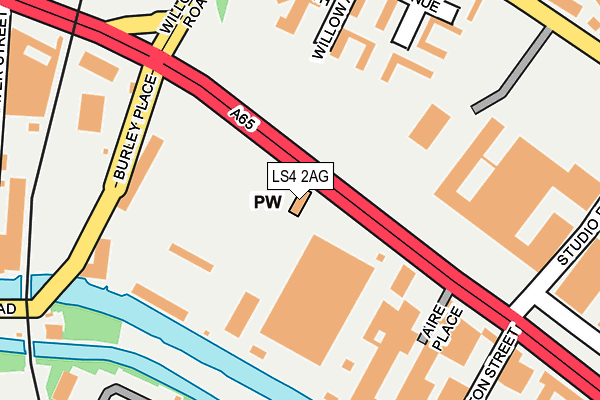
LS4 2AG lies on Kirkstall Road in Leeds. LS4 2AG is located in the Little London & Woodhouse electoral ward, within the metropolitan district of Leeds and the English Parliamentary constituency of Leeds Central. The Sub Integrated Care Board (ICB) Location is NHS West Yorkshire ICB - 15F and the police force is West Yorkshire. This postcode has been in use since January 1980.


GetTheData
Source: OS OpenMap – Local (Ordnance Survey)
Source: OS VectorMap District (Ordnance Survey)
Licence: Open Government Licence (requires attribution)
| Easting | 428174 |
| Northing | 434182 |
| Latitude | 53.803179 |
| Longitude | -1.573696 |
GetTheData
Source: Open Postcode Geo
Licence: Open Government Licence
| Street | Kirkstall Road |
| Town/City | Leeds |
| Country | England |
| Postcode District | LS4 |
➜ See where LS4 is on a map ➜ Where is Leeds? | |
GetTheData
Source: Land Registry Price Paid Data
Licence: Open Government Licence
Elevation or altitude of LS4 2AG as distance above sea level:
| Metres | Feet | |
|---|---|---|
| Elevation | 30m | 98ft |
Elevation is measured from the approximate centre of the postcode, to the nearest point on an OS contour line from OS Terrain 50, which has contour spacing of ten vertical metres.
➜ How high above sea level am I? Find the elevation of your current position using your device's GPS.
GetTheData
Source: Open Postcode Elevation
Licence: Open Government Licence
| Ward | Little London & Woodhouse |
| Constituency | Leeds Central |
GetTheData
Source: ONS Postcode Database
Licence: Open Government Licence
155, KIRKSTALL ROAD, LEEDS, LS4 2AG 2010 19 FEB £330,000 |
GetTheData
Source: HM Land Registry Price Paid Data
Licence: Contains HM Land Registry data © Crown copyright and database right 2025. This data is licensed under the Open Government Licence v3.0.
| Kirkstall Road Yorkshire Tv (Kirkstall Road) | Hyde Park | 28m |
| Kirkstall Rd Willow Road (Kirkstall Road) | Hyde Park | 108m |
| Kirkstall Road Yorkshire Tv (Kirkstall Road) | Hyde Park | 154m |
| Viaduct Road Burley Place (Viaduct Road) | Hyde Park | 165m |
| Burley Place Viaduct Rd (Burley Place) | Hyde Park | 199m |
| Burley Park Station | 1km |
| Leeds Station | 1.9km |
| Headingley Station | 2.1km |
GetTheData
Source: NaPTAN
Licence: Open Government Licence
GetTheData
Source: ONS Postcode Database
Licence: Open Government Licence


➜ Get more ratings from the Food Standards Agency
GetTheData
Source: Food Standards Agency
Licence: FSA terms & conditions
| Last Collection | |||
|---|---|---|---|
| Location | Mon-Fri | Sat | Distance |
| Woodsley Road P.o. | 18:30 | 12:00 | 477m |
| Opposite 58 Burley Road | 17:30 | 12:30 | 497m |
| Lyceum | 17:30 | 11:30 | 523m |
GetTheData
Source: Dracos
Licence: Creative Commons Attribution-ShareAlike
| Risk of LS4 2AG flooding from rivers and sea | High |
| ➜ LS4 2AG flood map | |
GetTheData
Source: Open Flood Risk by Postcode
Licence: Open Government Licence
The below table lists the International Territorial Level (ITL) codes (formerly Nomenclature of Territorial Units for Statistics (NUTS) codes) and Local Administrative Units (LAU) codes for LS4 2AG:
| ITL 1 Code | Name |
|---|---|
| TLE | Yorkshire and The Humber |
| ITL 2 Code | Name |
| TLE4 | West Yorkshire |
| ITL 3 Code | Name |
| TLE42 | Leeds |
| LAU 1 Code | Name |
| E08000035 | Leeds |
GetTheData
Source: ONS Postcode Directory
Licence: Open Government Licence
The below table lists the Census Output Area (OA), Lower Layer Super Output Area (LSOA), and Middle Layer Super Output Area (MSOA) for LS4 2AG:
| Code | Name | |
|---|---|---|
| OA | E00057859 | |
| LSOA | E01011483 | Leeds 056E |
| MSOA | E02002385 | Leeds 056 |
GetTheData
Source: ONS Postcode Directory
Licence: Open Government Licence
| LS4 2HG | Willow Close | 171m |
| LS4 2AH | Kirkstall Road | 189m |
| LS4 2HE | Willow Approach | 195m |
| LS4 2HF | Willow Avenue | 248m |
| LS4 2EU | Burley Road | 310m |
| LS4 2AU | Weaver Street | 319m |
| LS4 2BE | Bodley Terrace | 332m |
| LS6 1QA | Burley Lodge Terrace | 333m |
| LS6 1QQ | Carberry Road | 337m |
| LS6 1QB | Burley Lodge Street | 346m |
GetTheData
Source: Open Postcode Geo; Land Registry Price Paid Data
Licence: Open Government Licence