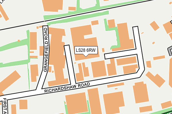
LS28 6RW lies on Richardshaw Road in Grangefield Industrial Estate, Pudsey. LS28 6RW is located in the Pudsey electoral ward, within the metropolitan district of Leeds and the English Parliamentary constituency of Pudsey. The Sub Integrated Care Board (ICB) Location is NHS West Yorkshire ICB - 15F and the police force is West Yorkshire. This postcode has been in use since June 2000.


GetTheData
Source: OS OpenMap – Local (Ordnance Survey)
Source: OS VectorMap District (Ordnance Survey)
Licence: Open Government Licence (requires attribution)
| Easting | 422591 |
| Northing | 434348 |
| Latitude | 53.804958 |
| Longitude | -1.658457 |
GetTheData
Source: Open Postcode Geo
Licence: Open Government Licence
| Street | Richardshaw Road |
| Locality | Grangefield Industrial Estate |
| Town/City | Pudsey |
| Country | England |
| Postcode District | LS28 |
➜ See where LS28 is on a map ➜ Where is Pudsey? | |
GetTheData
Source: Land Registry Price Paid Data
Licence: Open Government Licence
Elevation or altitude of LS28 6RW as distance above sea level:
| Metres | Feet | |
|---|---|---|
| Elevation | 130m | 427ft |
Elevation is measured from the approximate centre of the postcode, to the nearest point on an OS contour line from OS Terrain 50, which has contour spacing of ten vertical metres.
➜ How high above sea level am I? Find the elevation of your current position using your device's GPS.
GetTheData
Source: Open Postcode Elevation
Licence: Open Government Licence
| Ward | Pudsey |
| Constituency | Pudsey |
GetTheData
Source: ONS Postcode Database
Licence: Open Government Licence
| Town St Grangefield Road (Town Street) | Stanningley | 338m |
| Town Street Arthur St (Town Street) | Stanningley | 340m |
| Town Street Half Mile La (Town Street) | Stanningley | 383m |
| Stanningley Road Norwood Cres (Stanningley Road) | Stanningley | 425m |
| Town St Slaters Road (Town Street) | Stanningley | 462m |
| Bramley (West Yorks) Station | 1.4km |
| New Pudsey Station | 1.5km |
| Kirkstall Forge Station | 3.2km |
GetTheData
Source: NaPTAN
Licence: Open Government Licence
GetTheData
Source: ONS Postcode Database
Licence: Open Government Licence
➜ Get more ratings from the Food Standards Agency
GetTheData
Source: Food Standards Agency
Licence: FSA terms & conditions
| Last Collection | |||
|---|---|---|---|
| Location | Mon-Fri | Sat | Distance |
| Grangefield Estate | 191m | ||
| The Pavillion | 17:30 | 11:00 | 420m |
| Stanningley P.o. | 17:30 | 12:00 | 425m |
GetTheData
Source: Dracos
Licence: Creative Commons Attribution-ShareAlike
The below table lists the International Territorial Level (ITL) codes (formerly Nomenclature of Territorial Units for Statistics (NUTS) codes) and Local Administrative Units (LAU) codes for LS28 6RW:
| ITL 1 Code | Name |
|---|---|
| TLE | Yorkshire and The Humber |
| ITL 2 Code | Name |
| TLE4 | West Yorkshire |
| ITL 3 Code | Name |
| TLE42 | Leeds |
| LAU 1 Code | Name |
| E08000035 | Leeds |
GetTheData
Source: ONS Postcode Directory
Licence: Open Government Licence
The below table lists the Census Output Area (OA), Lower Layer Super Output Area (LSOA), and Middle Layer Super Output Area (MSOA) for LS28 6RW:
| Code | Name | |
|---|---|---|
| OA | E00058416 | |
| LSOA | E01011596 | Leeds 062D |
| MSOA | E02002391 | Leeds 062 |
GetTheData
Source: ONS Postcode Directory
Licence: Open Government Licence
| LS28 6QW | Richardshaw Road | 117m |
| LS28 6LF | Grangefield Road | 124m |
| LS28 6NH | Norwood Croft | 228m |
| LS28 6HE | Milestone Court | 325m |
| LS28 6NG | Norwood Crescent | 337m |
| LS28 6EX | Vernon Place | 342m |
| LS28 6BP | Victoria Villas | 352m |
| LS28 6AD | Palmerston Close | 361m |
| LS28 6EZ | Town Street | 362m |
| LS28 6NQ | Rosebery Terrace | 389m |
GetTheData
Source: Open Postcode Geo; Land Registry Price Paid Data
Licence: Open Government Licence