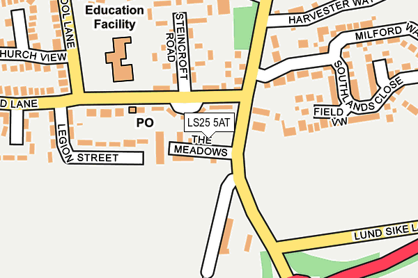
LS25 5AT is located in the Monk Fryston & South Milford electoral ward, within the unitary authority of North Yorkshire and the English Parliamentary constituency of Selby and Ainsty. The Sub Integrated Care Board (ICB) Location is NHS Humber and North Yorkshire ICB - 03Q and the police force is North Yorkshire. This postcode has been in use since January 1980.


GetTheData
Source: OS OpenMap – Local (Ordnance Survey)
Source: OS VectorMap District (Ordnance Survey)
Licence: Open Government Licence (requires attribution)
| Easting | 449562 |
| Northing | 431208 |
| Latitude | 53.774858 |
| Longitude | -1.249448 |
GetTheData
Source: Open Postcode Geo
Licence: Open Government Licence
| Country | England |
| Postcode District | LS25 |
➜ See where LS25 is on a map ➜ Where is South Milford? | |
GetTheData
Source: Land Registry Price Paid Data
Licence: Open Government Licence
Elevation or altitude of LS25 5AT as distance above sea level:
| Metres | Feet | |
|---|---|---|
| Elevation | 20m | 66ft |
Elevation is measured from the approximate centre of the postcode, to the nearest point on an OS contour line from OS Terrain 50, which has contour spacing of ten vertical metres.
➜ How high above sea level am I? Find the elevation of your current position using your device's GPS.
GetTheData
Source: Open Postcode Elevation
Licence: Open Government Licence
| Ward | Monk Fryston & South Milford |
| Constituency | Selby And Ainsty |
GetTheData
Source: ONS Postcode Database
Licence: Open Government Licence
| Steincroft Road (Sand Lane) | South Milford | 63m |
| Steincroft Road (Sand Lane) | South Milford | 70m |
| Beech Drive (Low Street) | South Milford | 201m |
| Beech Drive (Low Street) | South Milford | 202m |
| Grove Crescent (Sand Lane) | South Milford | 252m |
| South Milford Station | 0.8km |
| Sherburn-in-Elmet Station | 2.7km |
GetTheData
Source: NaPTAN
Licence: Open Government Licence
Estimated total energy consumption in LS25 5AT by fuel type, 2015.
| Consumption (kWh) | 122,420 |
|---|---|
| Meter count | 9 |
| Mean (kWh/meter) | 13,602 |
| Median (kWh/meter) | 11,126 |
GetTheData
Source: Postcode level gas estimates: 2015 (experimental)
Source: Postcode level electricity estimates: 2015 (experimental)
Licence: Open Government Licence
GetTheData
Source: ONS Postcode Database
Licence: Open Government Licence


➜ Get more ratings from the Food Standards Agency
GetTheData
Source: Food Standards Agency
Licence: FSA terms & conditions
| Last Collection | |||
|---|---|---|---|
| Location | Mon-Fri | Sat | Distance |
| South Milford P.o. | 17:30 | 11:00 | 391m |
| Common Lane/Mill Lane | 16:15 | 09:45 | 516m |
| Highfields | 17:00 | 09:00 | 1,398m |
GetTheData
Source: Dracos
Licence: Creative Commons Attribution-ShareAlike
The below table lists the International Territorial Level (ITL) codes (formerly Nomenclature of Territorial Units for Statistics (NUTS) codes) and Local Administrative Units (LAU) codes for LS25 5AT:
| ITL 1 Code | Name |
|---|---|
| TLE | Yorkshire and The Humber |
| ITL 2 Code | Name |
| TLE2 | North Yorkshire |
| ITL 3 Code | Name |
| TLE22 | North Yorkshire CC |
| LAU 1 Code | Name |
| E07000169 | Selby |
GetTheData
Source: ONS Postcode Directory
Licence: Open Government Licence
The below table lists the Census Output Area (OA), Lower Layer Super Output Area (LSOA), and Middle Layer Super Output Area (MSOA) for LS25 5AT:
| Code | Name | |
|---|---|---|
| OA | E00142140 | |
| LSOA | E01027898 | Selby 004A |
| MSOA | E02005812 | Selby 004 |
GetTheData
Source: ONS Postcode Directory
Licence: Open Government Licence
| LS25 5NG | The Meadows | 51m |
| LS25 5FA | Southlands Close | 136m |
| LS25 5GH | Field View | 143m |
| LS25 5AX | Steincroft Road | 158m |
| LS25 5DP | London Road | 167m |
| LS25 5AY | Legion Street | 182m |
| LS25 5NP | Maple Close | 231m |
| LS25 5AU | Sand Lane | 242m |
| LS25 5NU | Southlands Close | 245m |
| LS25 5FJ | Mill Close | 253m |
GetTheData
Source: Open Postcode Geo; Land Registry Price Paid Data
Licence: Open Government Licence