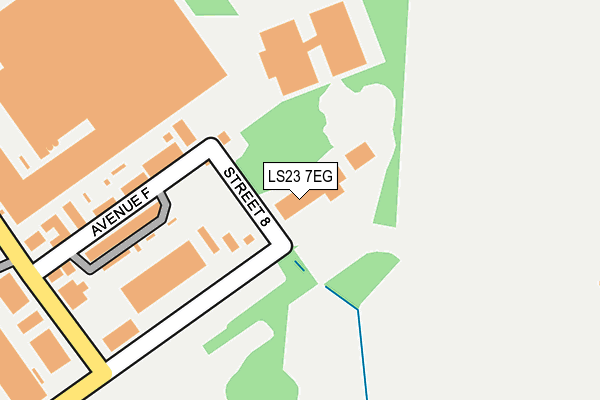
LS23 7EG is located in the Wetherby electoral ward, within the metropolitan district of Leeds and the English Parliamentary constituency of Elmet and Rothwell. The Sub Integrated Care Board (ICB) Location is NHS West Yorkshire ICB - 15F and the police force is West Yorkshire. This postcode has been in use since August 2008.


GetTheData
Source: OS OpenMap – Local (Ordnance Survey)
Source: OS VectorMap District (Ordnance Survey)
Licence: Open Government Licence (requires attribution)
| Easting | 445588 |
| Northing | 446428 |
| Latitude | 53.912023 |
| Longitude | -1.307495 |
GetTheData
Source: Open Postcode Geo
Licence: Open Government Licence
| Country | England |
| Postcode District | LS23 |
➜ See where LS23 is on a map ➜ Where is Thorp Arch? | |
GetTheData
Source: Land Registry Price Paid Data
Licence: Open Government Licence
Elevation or altitude of LS23 7EG as distance above sea level:
| Metres | Feet | |
|---|---|---|
| Elevation | 10m | 33ft |
Elevation is measured from the approximate centre of the postcode, to the nearest point on an OS contour line from OS Terrain 50, which has contour spacing of ten vertical metres.
➜ How high above sea level am I? Find the elevation of your current position using your device's GPS.
GetTheData
Source: Open Postcode Elevation
Licence: Open Government Licence
| Ward | Wetherby |
| Constituency | Elmet And Rothwell |
GetTheData
Source: ONS Postcode Database
Licence: Open Government Licence
| Trading Estate Avenue F (Street 7) | Thorp Arch | 173m |
| Ave E West Street 7 (Avenue E West) | Thorp Arch | 207m |
| Ave E Street 5 (Avenue E East) | Thorp Arch | 551m |
| Trading Estate Avenue C West (Avenue C West) | Thorp Arch | 587m |
| Street 5 Ave D (Street 5) | Thorp Arch | 670m |
GetTheData
Source: NaPTAN
Licence: Open Government Licence
GetTheData
Source: ONS Postcode Database
Licence: Open Government Licence


➜ Get more ratings from the Food Standards Agency
GetTheData
Source: Food Standards Agency
Licence: FSA terms & conditions
| Last Collection | |||
|---|---|---|---|
| Location | Mon-Fri | Sat | Distance |
| Walton Road | 17:45 | 09:15 | 1,639m |
| Boston Spa P.o. | 17:30 | 12:00 | 2,580m |
| Kelcbar Court/Close | 17:45 | 12:30 | 3,536m |
GetTheData
Source: Dracos
Licence: Creative Commons Attribution-ShareAlike
The below table lists the International Territorial Level (ITL) codes (formerly Nomenclature of Territorial Units for Statistics (NUTS) codes) and Local Administrative Units (LAU) codes for LS23 7EG:
| ITL 1 Code | Name |
|---|---|
| TLE | Yorkshire and The Humber |
| ITL 2 Code | Name |
| TLE4 | West Yorkshire |
| ITL 3 Code | Name |
| TLE42 | Leeds |
| LAU 1 Code | Name |
| E08000035 | Leeds |
GetTheData
Source: ONS Postcode Directory
Licence: Open Government Licence
The below table lists the Census Output Area (OA), Lower Layer Super Output Area (LSOA), and Middle Layer Super Output Area (MSOA) for LS23 7EG:
| Code | Name | |
|---|---|---|
| OA | E00059010 | |
| LSOA | E01011697 | Leeds 002A |
| MSOA | E02002331 | Leeds 002 |
GetTheData
Source: ONS Postcode Directory
Licence: Open Government Licence
| LS24 8BJ | Walton Lodge Farm Cottages | 589m |
| LS24 9TD | St Helens Mews | 1558m |
| LS24 9LS | Main Street | 1579m |
| LS24 9FA | St Andrews Walk | 1619m |
| LS24 9FB | Barwick Place | 1622m |
| LS23 7EJ | Rudgate Park | 1652m |
| LS24 9LX | Papyrus Villas | 1683m |
| LS23 7BE | Northfields | 1701m |
| LS23 7RB | Rudgate Mews | 1708m |
| LS23 7BA | 1737m |
GetTheData
Source: Open Postcode Geo; Land Registry Price Paid Data
Licence: Open Government Licence