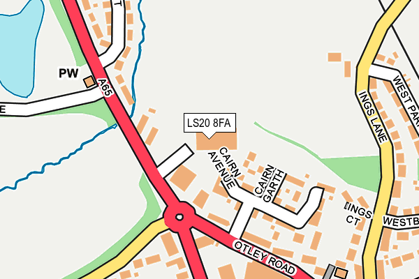
LS20 8FA is located in the Guiseley & Rawdon electoral ward, within the metropolitan district of Leeds and the English Parliamentary constituency of Pudsey. The Sub Integrated Care Board (ICB) Location is NHS West Yorkshire ICB - 15F and the police force is West Yorkshire. This postcode has been in use since December 2016.


GetTheData
Source: OS OpenMap – Local (Ordnance Survey)
Source: OS VectorMap District (Ordnance Survey)
Licence: Open Government Licence (requires attribution)
| Easting | 418170 |
| Northing | 442603 |
| Latitude | 53.879323 |
| Longitude | -1.725100 |
GetTheData
Source: Open Postcode Geo
Licence: Open Government Licence
| Country | England |
| Postcode District | LS20 |
➜ See where LS20 is on a map | |
GetTheData
Source: Land Registry Price Paid Data
Licence: Open Government Licence
Elevation or altitude of LS20 8FA as distance above sea level:
| Metres | Feet | |
|---|---|---|
| Elevation | 140m | 459ft |
Elevation is measured from the approximate centre of the postcode, to the nearest point on an OS contour line from OS Terrain 50, which has contour spacing of ten vertical metres.
➜ How high above sea level am I? Find the elevation of your current position using your device's GPS.
GetTheData
Source: Open Postcode Elevation
Licence: Open Government Licence
| Ward | Guiseley & Rawdon |
| Constituency | Pudsey |
GetTheData
Source: ONS Postcode Database
Licence: Open Government Licence
| White Cross (Bradford Road) | Guiseley | 156m |
| White Cross (Otley Road) | Guiseley | 166m |
| White Cross (Otley Road) | Guiseley | 178m |
| White Cross (Bradford Road) | Guiseley | 182m |
| Ings Lane West Park (Ings Lane) | Guiseley | 233m |
| Guiseley Station | 0.8km |
| Menston Station | 1.6km |
| Burley-in-Wharfedale Station | 3.7km |
GetTheData
Source: NaPTAN
Licence: Open Government Licence
GetTheData
Source: ONS Postcode Database
Licence: Open Government Licence


➜ Get more ratings from the Food Standards Agency
GetTheData
Source: Food Standards Agency
Licence: FSA terms & conditions
| Last Collection | |||
|---|---|---|---|
| Location | Mon-Fri | Sat | Distance |
| White Cross P.o. | 18:15 | 11:30 | 277m |
| 2 Ings Lane | 18:15 | 11:30 | 364m |
| Netherfield Road | 18:15 | 11:45 | 445m |
GetTheData
Source: Dracos
Licence: Creative Commons Attribution-ShareAlike
The below table lists the International Territorial Level (ITL) codes (formerly Nomenclature of Territorial Units for Statistics (NUTS) codes) and Local Administrative Units (LAU) codes for LS20 8FA:
| ITL 1 Code | Name |
|---|---|
| TLE | Yorkshire and The Humber |
| ITL 2 Code | Name |
| TLE4 | West Yorkshire |
| ITL 3 Code | Name |
| TLE42 | Leeds |
| LAU 1 Code | Name |
| E08000035 | Leeds |
GetTheData
Source: ONS Postcode Directory
Licence: Open Government Licence
The below table lists the Census Output Area (OA), Lower Layer Super Output Area (LSOA), and Middle Layer Super Output Area (MSOA) for LS20 8FA:
| Code | Name | |
|---|---|---|
| OA | E00056762 | |
| LSOA | E01011280 | Leeds 008D |
| MSOA | E02002337 | Leeds 008 |
GetTheData
Source: ONS Postcode Directory
Licence: Open Government Licence
| LS20 8QP | Cairn Garth | 99m |
| LS20 8QQ | Cairn Avenue | 153m |
| LS20 8LZ | Otley Road | 162m |
| LS20 8LY | Otley Road | 200m |
| LS20 8NG | Thorpe Lane | 225m |
| LS20 8DF | Ings Court | 230m |
| LS20 8DA | Ings Lane | 248m |
| LS20 8NQ | Tranmere Drive | 254m |
| LS29 6AF | Moorland Crescent | 270m |
| LS20 8BZ | West Park | 276m |
GetTheData
Source: Open Postcode Geo; Land Registry Price Paid Data
Licence: Open Government Licence