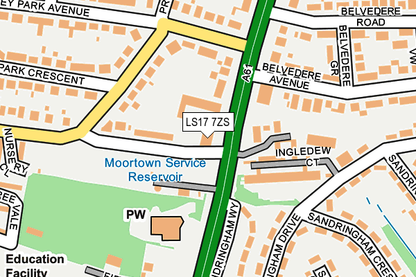
LS17 7ZS is located in the Alwoodley electoral ward, within the metropolitan district of Leeds and the English Parliamentary constituency of Leeds North East. The Sub Integrated Care Board (ICB) Location is NHS West Yorkshire ICB - 15F and the police force is West Yorkshire. This postcode has been in use since December 2000.


GetTheData
Source: OS OpenMap – Local (Ordnance Survey)
Source: OS VectorMap District (Ordnance Survey)
Licence: Open Government Licence (requires attribution)
| Easting | 430774 |
| Northing | 439554 |
| Latitude | 53.851314 |
| Longitude | -1.533684 |
GetTheData
Source: Open Postcode Geo
Licence: Open Government Licence
| Country | England |
| Postcode District | LS17 |
➜ See where LS17 is on a map ➜ Where is Leeds? | |
GetTheData
Source: Land Registry Price Paid Data
Licence: Open Government Licence
Elevation or altitude of LS17 7ZS as distance above sea level:
| Metres | Feet | |
|---|---|---|
| Elevation | 160m | 525ft |
Elevation is measured from the approximate centre of the postcode, to the nearest point on an OS contour line from OS Terrain 50, which has contour spacing of ten vertical metres.
➜ How high above sea level am I? Find the elevation of your current position using your device's GPS.
GetTheData
Source: Open Postcode Elevation
Licence: Open Government Licence
| Ward | Alwoodley |
| Constituency | Leeds North East |
GetTheData
Source: ONS Postcode Database
Licence: Open Government Licence
| Nursery Lane Primley Park Crescent (Nursery Lane) | Moortown | 109m |
| Primley Park Avenue Harrogate Rd (Primley Park Avenue) | Moortown | 137m |
| Harrogate Road Belvedere Rd (Harrogate Road) | Moortown | 141m |
| Primley Park Cres Primley Park Ave (Primley Park Crescent) | Moortown | 158m |
| Harrogate Road Belvedere Rd (Harrogate Road) | Moortown | 188m |
| Burley Park Station | 5.2km |
| Headingley Station | 5.4km |
GetTheData
Source: NaPTAN
Licence: Open Government Licence
GetTheData
Source: ONS Postcode Database
Licence: Open Government Licence


➜ Get more ratings from the Food Standards Agency
GetTheData
Source: Food Standards Agency
Licence: FSA terms & conditions
| Last Collection | |||
|---|---|---|---|
| Location | Mon-Fri | Sat | Distance |
| Hawknest | 17:30 | 11:15 | 122m |
| Moortown P.o. | 18:30 | 12:00 | 438m |
| Primley Park Road | 18:00 | 11:00 | 481m |
GetTheData
Source: Dracos
Licence: Creative Commons Attribution-ShareAlike
The below table lists the International Territorial Level (ITL) codes (formerly Nomenclature of Territorial Units for Statistics (NUTS) codes) and Local Administrative Units (LAU) codes for LS17 7ZS:
| ITL 1 Code | Name |
|---|---|
| TLE | Yorkshire and The Humber |
| ITL 2 Code | Name |
| TLE4 | West Yorkshire |
| ITL 3 Code | Name |
| TLE42 | Leeds |
| LAU 1 Code | Name |
| E08000035 | Leeds |
GetTheData
Source: ONS Postcode Directory
Licence: Open Government Licence
The below table lists the Census Output Area (OA), Lower Layer Super Output Area (LSOA), and Middle Layer Super Output Area (MSOA) for LS17 7ZS:
| Code | Name | |
|---|---|---|
| OA | E00058245 | |
| LSOA | E01011556 | Leeds 015A |
| MSOA | E02002344 | Leeds 015 |
GetTheData
Source: ONS Postcode Directory
Licence: Open Government Licence
| LS17 7AA | Cavendish Mews | 53m |
| LS17 7AB | Harrogate Road | 101m |
| LS17 8BL | Harrogate Road | 104m |
| LS17 8TP | Ingledew Court | 115m |
| LS17 8TY | Ingledew Court | 115m |
| LS17 8UJ | Sandringham Drive | 172m |
| LS17 8BX | Sandringham Way | 174m |
| LS17 8BZ | Sandringham Drive | 178m |
| LS17 8BN | Belvedere Avenue | 201m |
| LS17 7JA | Primley Park Avenue | 212m |
GetTheData
Source: Open Postcode Geo; Land Registry Price Paid Data
Licence: Open Government Licence