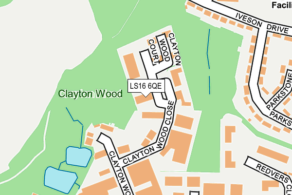
LS16 6QE lies on Clayton Wood Close in Leeds. LS16 6QE is located in the Weetwood electoral ward, within the metropolitan district of Leeds and the English Parliamentary constituency of Leeds North West. The Sub Integrated Care Board (ICB) Location is NHS West Yorkshire ICB - 15F and the police force is West Yorkshire. This postcode has been in use since January 1980.


GetTheData
Source: OS OpenMap – Local (Ordnance Survey)
Source: OS VectorMap District (Ordnance Survey)
Licence: Open Government Licence (requires attribution)
| Easting | 425823 |
| Northing | 438390 |
| Latitude | 53.841136 |
| Longitude | -1.609044 |
GetTheData
Source: Open Postcode Geo
Licence: Open Government Licence
| Street | Clayton Wood Close |
| Town/City | Leeds |
| Country | England |
| Postcode District | LS16 |
➜ See where LS16 is on a map ➜ Where is Leeds? | |
GetTheData
Source: Land Registry Price Paid Data
Licence: Open Government Licence
Elevation or altitude of LS16 6QE as distance above sea level:
| Metres | Feet | |
|---|---|---|
| Elevation | 120m | 394ft |
Elevation is measured from the approximate centre of the postcode, to the nearest point on an OS contour line from OS Terrain 50, which has contour spacing of ten vertical metres.
➜ How high above sea level am I? Find the elevation of your current position using your device's GPS.
GetTheData
Source: Open Postcode Elevation
Licence: Open Government Licence
| Ward | Weetwood |
| Constituency | Leeds North West |
GetTheData
Source: ONS Postcode Database
Licence: Open Government Licence
DATONG ELECTRONICS PLC, CLAYTON WOOD CLOSE, LEEDS, LS16 6QE 2011 9 AUG £375,000 |
GetTheData
Source: HM Land Registry Price Paid Data
Licence: Contains HM Land Registry data © Crown copyright and database right 2024. This data is licensed under the Open Government Licence v3.0.
| Iveson Drive Parkstone Grove (Iveson Drive) | Ireland Wood | 256m |
| Iveson Drive Parkstone Grove (Iveson Drive) | Ireland Wood | 281m |
| Iveson Approach Iveson Drive (Iveson Approach) | Ireland Wood | 289m |
| Ring Rd Redvers Close (Ring Road West Park) | Moor Grange | 335m |
| Iveson Approach Iveson Crescent (Iveson Approach) | Ireland Wood | 338m |
| Horsforth Station | 1.6km |
| Kirkstall Forge Station | 2.1km |
| Headingley Station | 2.8km |
GetTheData
Source: NaPTAN
Licence: Open Government Licence
Estimated total energy consumption in LS16 6QE by fuel type, 2015.
| Consumption (kWh) | 312,974 |
|---|---|
| Meter count | 13 |
| Mean (kWh/meter) | 24,075 |
| Median (kWh/meter) | 20,584 |
GetTheData
Source: Postcode level gas estimates: 2015 (experimental)
Source: Postcode level electricity estimates: 2015 (experimental)
Licence: Open Government Licence
GetTheData
Source: ONS Postcode Database
Licence: Open Government Licence


➜ Get more ratings from the Food Standards Agency
GetTheData
Source: Food Standards Agency
Licence: FSA terms & conditions
| Last Collection | |||
|---|---|---|---|
| Location | Mon-Fri | Sat | Distance |
| Clayton Wood Rise/Ring Road | 18:30 | 10:45 | 277m |
| Redvers Close/Ring Road | 18:30 | 365m | |
| Iveson Road/Iveson Approach | 17:45 | 11:30 | 484m |
GetTheData
Source: Dracos
Licence: Creative Commons Attribution-ShareAlike
The below table lists the International Territorial Level (ITL) codes (formerly Nomenclature of Territorial Units for Statistics (NUTS) codes) and Local Administrative Units (LAU) codes for LS16 6QE:
| ITL 1 Code | Name |
|---|---|
| TLE | Yorkshire and The Humber |
| ITL 2 Code | Name |
| TLE4 | West Yorkshire |
| ITL 3 Code | Name |
| TLE42 | Leeds |
| LAU 1 Code | Name |
| E08000035 | Leeds |
GetTheData
Source: ONS Postcode Directory
Licence: Open Government Licence
The below table lists the Census Output Area (OA), Lower Layer Super Output Area (LSOA), and Middle Layer Super Output Area (MSOA) for LS16 6QE:
| Code | Name | |
|---|---|---|
| OA | E00058939 | |
| LSOA | E01011686 | Leeds 033E |
| MSOA | E02002362 | Leeds 033 |
GetTheData
Source: ONS Postcode Directory
Licence: Open Government Licence
| LS16 6QN | Clayton Wood Rise | 224m |
| LS16 6EX | Parkstone Grove | 243m |
| LS16 6PA | Iveson Drive | 246m |
| LS16 6NY | Iveson Drive | 257m |
| LS16 6EU | Parkstone Green | 283m |
| LS16 6ET | Parkstone Grove | 320m |
| LS16 6ES | Parkstone Mount | 340m |
| LS16 6NS | Iveson Drive | 345m |
| LS16 6NR | Iveson Drive | 368m |
| LS16 6SS | Lawnswood Business Park | 377m |
GetTheData
Source: Open Postcode Geo; Land Registry Price Paid Data
Licence: Open Government Licence