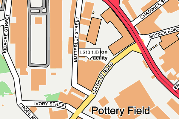
LS10 1JD is located in the Hunslet & Riverside electoral ward, within the metropolitan district of Leeds and the English Parliamentary constituency of Leeds Central. The Sub Integrated Care Board (ICB) Location is NHS West Yorkshire ICB - 15F and the police force is West Yorkshire. This postcode has been in use since October 2002.


GetTheData
Source: OS OpenMap – Local (Ordnance Survey)
Source: OS VectorMap District (Ordnance Survey)
Licence: Open Government Licence (requires attribution)
| Easting | 430540 |
| Northing | 432460 |
| Latitude | 53.787569 |
| Longitude | -1.537943 |
GetTheData
Source: Open Postcode Geo
Licence: Open Government Licence
| Country | England |
| Postcode District | LS10 |
➜ See where LS10 is on a map ➜ Where is Leeds? | |
GetTheData
Source: Land Registry Price Paid Data
Licence: Open Government Licence
Elevation or altitude of LS10 1JD as distance above sea level:
| Metres | Feet | |
|---|---|---|
| Elevation | 30m | 98ft |
Elevation is measured from the approximate centre of the postcode, to the nearest point on an OS contour line from OS Terrain 50, which has contour spacing of ten vertical metres.
➜ How high above sea level am I? Find the elevation of your current position using your device's GPS.
GetTheData
Source: Open Postcode Elevation
Licence: Open Government Licence
| Ward | Hunslet & Riverside |
| Constituency | Leeds Central |
GetTheData
Source: ONS Postcode Database
Licence: Open Government Licence
| Hunslet Road Chadwick St (Hunslet Road) | Crown Point | 173m |
| Hunslet Road Chadwick St (Hunslet Road) | Crown Point | 189m |
| Hunslet Road Brookfield St (Hunslet Road) | Crown Point | 243m |
| Shopping Park (Hunslet Lane) | Crown Point | 283m |
| Hunslet Road Brookfield St (Hunslet Road) | Crown Point | 309m |
| Leeds Station | 1.1km |
| Burley Park Station | 3.8km |
| Cottingley Station | 3.9km |
GetTheData
Source: NaPTAN
Licence: Open Government Licence
GetTheData
Source: ONS Postcode Database
Licence: Open Government Licence


➜ Get more ratings from the Food Standards Agency
GetTheData
Source: Food Standards Agency
Licence: FSA terms & conditions
| Last Collection | |||
|---|---|---|---|
| Location | Mon-Fri | Sat | Distance |
| Crown Point Retail Park | 18:15 | 12:30 | 224m |
| Chadwick Street Bus Box | 18:45 | 11:00 | 371m |
| Chadwick Street South | 18:45 | 12:30 | 373m |
GetTheData
Source: Dracos
Licence: Creative Commons Attribution-ShareAlike
| Risk of LS10 1JD flooding from rivers and sea | Low |
| ➜ LS10 1JD flood map | |
GetTheData
Source: Open Flood Risk by Postcode
Licence: Open Government Licence
The below table lists the International Territorial Level (ITL) codes (formerly Nomenclature of Territorial Units for Statistics (NUTS) codes) and Local Administrative Units (LAU) codes for LS10 1JD:
| ITL 1 Code | Name |
|---|---|
| TLE | Yorkshire and The Humber |
| ITL 2 Code | Name |
| TLE4 | West Yorkshire |
| ITL 3 Code | Name |
| TLE42 | Leeds |
| LAU 1 Code | Name |
| E08000035 | Leeds |
GetTheData
Source: ONS Postcode Directory
Licence: Open Government Licence
The below table lists the Census Output Area (OA), Lower Layer Super Output Area (LSOA), and Middle Layer Super Output Area (MSOA) for LS10 1JD:
| Code | Name | |
|---|---|---|
| OA | E00170035 | |
| LSOA | E01033016 | Leeds 111E |
| MSOA | E02006875 | Leeds 111 |
GetTheData
Source: ONS Postcode Directory
Licence: Open Government Licence
| LS10 1ET | Crown Point Retail Park | 216m |
| LS10 1LJ | Chadwick Street | 366m |
| LS10 1JX | Brookfield Street | 395m |
| LS10 1BS | Jack Lane | 400m |
| LS10 1NW | Chadwick Street | 414m |
| LS10 1HW | Black Bull Street | 416m |
| LS10 1NH | Chadwick Street | 431m |
| LS10 1BN | Jack Lane | 432m |
| LS10 1BX | Grape Street | 434m |
| LS10 1LG | The Boulevard | 438m |
GetTheData
Source: Open Postcode Geo; Land Registry Price Paid Data
Licence: Open Government Licence