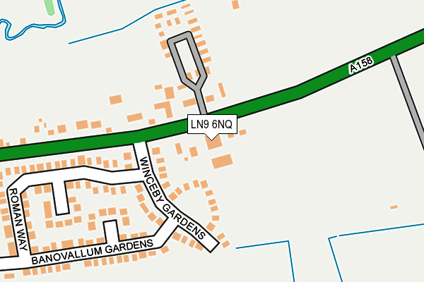
LN9 6NQ is located in the Horncastle electoral ward, within the local authority district of East Lindsey and the English Parliamentary constituency of Louth and Horncastle. The Sub Integrated Care Board (ICB) Location is NHS Lincolnshire ICB - 71E and the police force is Lincolnshire. This postcode has been in use since January 1980.


GetTheData
Source: OS OpenMap – Local (Ordnance Survey)
Source: OS VectorMap District (Ordnance Survey)
Licence: Open Government Licence (requires attribution)
| Easting | 527078 |
| Northing | 369547 |
| Latitude | 53.207807 |
| Longitude | -0.098700 |
GetTheData
Source: Open Postcode Geo
Licence: Open Government Licence
| Country | England |
| Postcode District | LN9 |
➜ See where LN9 is on a map | |
GetTheData
Source: Land Registry Price Paid Data
Licence: Open Government Licence
Elevation or altitude of LN9 6NQ as distance above sea level:
| Metres | Feet | |
|---|---|---|
| Elevation | 40m | 131ft |
Elevation is measured from the approximate centre of the postcode, to the nearest point on an OS contour line from OS Terrain 50, which has contour spacing of ten vertical metres.
➜ How high above sea level am I? Find the elevation of your current position using your device's GPS.
GetTheData
Source: Open Postcode Elevation
Licence: Open Government Licence
| Ward | Horncastle |
| Constituency | Louth And Horncastle |
GetTheData
Source: ONS Postcode Database
Licence: Open Government Licence
| Winceby Gardens (Spilsby Road) | Horncastle | 61m |
| Winceby Gardens (Spilsby Road) | Horncastle | 69m |
| St Lawrence School (Bowl Alley Lane) | Horncastle | 733m |
| Wesley Way (Mareham Road) | Horncastle | 767m |
| The Green (Tennyson Gardens) | Horncastle | 789m |
GetTheData
Source: NaPTAN
Licence: Open Government Licence
GetTheData
Source: ONS Postcode Database
Licence: Open Government Licence


➜ Get more ratings from the Food Standards Agency
GetTheData
Source: Food Standards Agency
Licence: FSA terms & conditions
The below table lists the International Territorial Level (ITL) codes (formerly Nomenclature of Territorial Units for Statistics (NUTS) codes) and Local Administrative Units (LAU) codes for LN9 6NQ:
| ITL 1 Code | Name |
|---|---|
| TLF | East Midlands (England) |
| ITL 2 Code | Name |
| TLF3 | Lincolnshire |
| ITL 3 Code | Name |
| TLF30 | Lincolnshire CC |
| LAU 1 Code | Name |
| E07000137 | East Lindsey |
GetTheData
Source: ONS Postcode Directory
Licence: Open Government Licence
The below table lists the Census Output Area (OA), Lower Layer Super Output Area (LSOA), and Middle Layer Super Output Area (MSOA) for LN9 6NQ:
| Code | Name | |
|---|---|---|
| OA | E00132265 | |
| LSOA | E01026065 | East Lindsey 011B |
| MSOA | E02005434 | East Lindsey 011 |
GetTheData
Source: ONS Postcode Directory
Licence: Open Government Licence
| LN9 6NE | Spilsby Road | 30m |
| LN9 6PJ | Winceby Gardens | 152m |
| LN9 6PL | Roman Way | 244m |
| LN9 6PN | Banovallum Gardens | 292m |
| LN9 6AW | Spilsby Road | 351m |
| LN9 6PR | Saxon Way | 387m |
| LN9 6RG | Islip Court | 425m |
| LN9 6RZ | Lodington Court | 446m |
| LN9 6RF | Banovallum Gardens | 499m |
| LN9 6QX | Maltby Way | 501m |
GetTheData
Source: Open Postcode Geo; Land Registry Price Paid Data
Licence: Open Government Licence