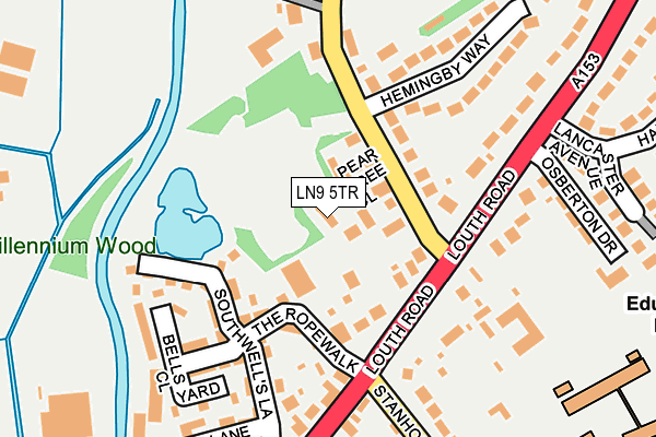
LN9 5TR lies on Pear Tree Close in Horncastle. LN9 5TR is located in the Horncastle electoral ward, within the local authority district of East Lindsey and the English Parliamentary constituency of Louth and Horncastle. The Sub Integrated Care Board (ICB) Location is NHS Lincolnshire ICB - 71E and the police force is Lincolnshire. This postcode has been in use since December 2000.


GetTheData
Source: OS OpenMap – Local (Ordnance Survey)
Source: OS VectorMap District (Ordnance Survey)
Licence: Open Government Licence (requires attribution)
| Easting | 526084 |
| Northing | 370057 |
| Latitude | 53.212626 |
| Longitude | -0.113373 |
GetTheData
Source: Open Postcode Geo
Licence: Open Government Licence
| Street | Pear Tree Close |
| Town/City | Horncastle |
| Country | England |
| Postcode District | LN9 |
➜ See where LN9 is on a map ➜ Where is Horncastle? | |
GetTheData
Source: Land Registry Price Paid Data
Licence: Open Government Licence
Elevation or altitude of LN9 5TR as distance above sea level:
| Metres | Feet | |
|---|---|---|
| Elevation | 30m | 98ft |
Elevation is measured from the approximate centre of the postcode, to the nearest point on an OS contour line from OS Terrain 50, which has contour spacing of ten vertical metres.
➜ How high above sea level am I? Find the elevation of your current position using your device's GPS.
GetTheData
Source: Open Postcode Elevation
Licence: Open Government Licence
| Ward | Horncastle |
| Constituency | Louth And Horncastle |
GetTheData
Source: ONS Postcode Database
Licence: Open Government Licence
2014 7 NOV £248,000 |
2001 6 JUN £130,000 |
4, PEAR TREE CLOSE, HORNCASTLE, LN9 5TR 2001 25 MAY £140,000 |
3, PEAR TREE CLOSE, HORNCASTLE, LN9 5TR 2000 28 NOV £130,000 |
2, PEAR TREE CLOSE, HORNCASTLE, LN9 5TR 2000 31 JUL £120,000 |
GetTheData
Source: HM Land Registry Price Paid Data
Licence: Contains HM Land Registry data © Crown copyright and database right 2025. This data is licensed under the Open Government Licence v3.0.
| St Lawrence School (Bowl Alley Lane) | Horncastle | 385m |
| Ashwood Close (Prospect Street) | Horncastle | 445m |
| Corn Close (Prospect Street) | Horncastle | 456m |
| Interchange Shelter (High Street) | Horncastle | 499m |
| Chestnut Close (Mark Avenue) | Horncastle | 645m |
GetTheData
Source: NaPTAN
Licence: Open Government Licence
| Percentage of properties with Next Generation Access | 100.0% |
| Percentage of properties with Superfast Broadband | 100.0% |
| Percentage of properties with Ultrafast Broadband | 0.0% |
| Percentage of properties with Full Fibre Broadband | 0.0% |
Superfast Broadband is between 30Mbps and 300Mbps
Ultrafast Broadband is > 300Mbps
| Percentage of properties unable to receive 2Mbps | 0.0% |
| Percentage of properties unable to receive 5Mbps | 0.0% |
| Percentage of properties unable to receive 10Mbps | 0.0% |
| Percentage of properties unable to receive 30Mbps | 0.0% |
GetTheData
Source: Ofcom
Licence: Ofcom Terms of Use (requires attribution)
GetTheData
Source: ONS Postcode Database
Licence: Open Government Licence


➜ Get more ratings from the Food Standards Agency
GetTheData
Source: Food Standards Agency
Licence: FSA terms & conditions
The below table lists the International Territorial Level (ITL) codes (formerly Nomenclature of Territorial Units for Statistics (NUTS) codes) and Local Administrative Units (LAU) codes for LN9 5TR:
| ITL 1 Code | Name |
|---|---|
| TLF | East Midlands (England) |
| ITL 2 Code | Name |
| TLF3 | Lincolnshire |
| ITL 3 Code | Name |
| TLF30 | Lincolnshire CC |
| LAU 1 Code | Name |
| E07000137 | East Lindsey |
GetTheData
Source: ONS Postcode Directory
Licence: Open Government Licence
The below table lists the Census Output Area (OA), Lower Layer Super Output Area (LSOA), and Middle Layer Super Output Area (MSOA) for LN9 5TR:
| Code | Name | |
|---|---|---|
| OA | E00132278 | |
| LSOA | E01026065 | East Lindsey 011B |
| MSOA | E02005434 | East Lindsey 011 |
GetTheData
Source: ONS Postcode Directory
Licence: Open Government Licence
| LN9 5ES | Hemingby Lane | 92m |
| LN9 5BF | The Ropewalk | 103m |
| LN9 5ED | Louth Road | 145m |
| LN9 5DT | Southwells Lane | 147m |
| LN9 5BT | Bells Yard Close | 180m |
| LN9 5EN | Louth Road | 207m |
| LN9 5EU | Hemingby Way | 208m |
| LN9 5DS | Mill Lane | 231m |
| LN9 5EL | Stanhope Road | 240m |
| LN9 5DU | Dovecote Alley | 251m |
GetTheData
Source: Open Postcode Geo; Land Registry Price Paid Data
Licence: Open Government Licence