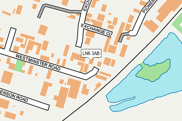
LN6 3AB lies on Exchange Road in North Hykeham, Lincoln. LN6 3AB is located in the Hykeham Memorial electoral ward, within the local authority district of North Kesteven and the English Parliamentary constituency of Sleaford and North Hykeham. The Sub Integrated Care Board (ICB) Location is NHS Lincolnshire ICB - 71E and the police force is Lincolnshire. This postcode has been in use since March 2011.


GetTheData
Source: OS OpenMap – Local (Ordnance Survey)
Source: OS VectorMap District (Ordnance Survey)
Licence: Open Government Licence (requires attribution)
| Easting | 494042 |
| Northing | 367797 |
| Latitude | 53.198967 |
| Longitude | -0.593675 |
GetTheData
Source: Open Postcode Geo
Licence: Open Government Licence
| Street | Exchange Road |
| Locality | North Hykeham |
| Town/City | Lincoln |
| Country | England |
| Postcode District | LN6 |
➜ See where LN6 is on a map ➜ Where is North Hykeham? | |
GetTheData
Source: Land Registry Price Paid Data
Licence: Open Government Licence
Elevation or altitude of LN6 3AB as distance above sea level:
| Metres | Feet | |
|---|---|---|
| Elevation | 10m | 33ft |
Elevation is measured from the approximate centre of the postcode, to the nearest point on an OS contour line from OS Terrain 50, which has contour spacing of ten vertical metres.
➜ How high above sea level am I? Find the elevation of your current position using your device's GPS.
GetTheData
Source: Open Postcode Elevation
Licence: Open Government Licence
| Ward | Hykeham Memorial |
| Constituency | Sleaford And North Hykeham |
GetTheData
Source: ONS Postcode Database
Licence: Open Government Licence
| Westminster Road (Station Road) | North Hykeham | 355m |
| Westminster Road (Station Road) | North Hykeham | 371m |
| Exchange Road (Doddington Road) | Lincoln | 374m |
| Exchange Road (Doddington Road) | Lincoln | 391m |
| Swanholme Tavern (Doddington Road) | Lincoln | 466m |
| Hykeham Station | 0.6km |
| Lincoln Central Station | 4.7km |
GetTheData
Source: NaPTAN
Licence: Open Government Licence
| Median download speed | 80.0Mbps |
| Average download speed | 64.6Mbps |
| Maximum download speed | 80.00Mbps |
| Median upload speed | 20.0Mbps |
| Average upload speed | 17.6Mbps |
| Maximum upload speed | 20.00Mbps |
GetTheData
Source: Ofcom
Licence: Ofcom Terms of Use (requires attribution)
GetTheData
Source: ONS Postcode Database
Licence: Open Government Licence


➜ Get more ratings from the Food Standards Agency
GetTheData
Source: Food Standards Agency
Licence: FSA terms & conditions
| Last Collection | |||
|---|---|---|---|
| Location | Mon-Fri | Sat | Distance |
| Pyke Road | 18:30 | 10:30 | 367m |
| Pyke Road | 18:30 | 00:01 | 371m |
| High Street | 16:45 | 11:00 | 644m |
GetTheData
Source: Dracos
Licence: Creative Commons Attribution-ShareAlike
The below table lists the International Territorial Level (ITL) codes (formerly Nomenclature of Territorial Units for Statistics (NUTS) codes) and Local Administrative Units (LAU) codes for LN6 3AB:
| ITL 1 Code | Name |
|---|---|
| TLF | East Midlands (England) |
| ITL 2 Code | Name |
| TLF3 | Lincolnshire |
| ITL 3 Code | Name |
| TLF30 | Lincolnshire CC |
| LAU 1 Code | Name |
| E07000139 | North Kesteven |
GetTheData
Source: ONS Postcode Directory
Licence: Open Government Licence
The below table lists the Census Output Area (OA), Lower Layer Super Output Area (LSOA), and Middle Layer Super Output Area (MSOA) for LN6 3AB:
| Code | Name | |
|---|---|---|
| OA | E00133121 | |
| LSOA | E01032991 | North Kesteven 014E |
| MSOA | E02006867 | North Kesteven 014 |
GetTheData
Source: ONS Postcode Directory
Licence: Open Government Licence
| LN6 3QY | Station Road | 133m |
| LN6 3JZ | Exchange Road | 190m |
| LN6 3QU | Stephenson Road | 242m |
| LN6 3DH | Pioneer Way | 282m |
| LN6 3JY | Low Moor Road | 352m |
| LN6 8SH | Clarke Road | 440m |
| LN6 3JA | Top Lodge Close | 454m |
| LN6 3DD | Swaythling Close | 462m |
| LN6 8SW | Constance Avenue | 467m |
| LN6 0QP | Pinewoods | 486m |
GetTheData
Source: Open Postcode Geo; Land Registry Price Paid Data
Licence: Open Government Licence