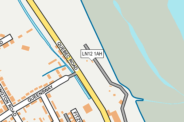
LN12 1AH is located in the Mablethorpe electoral ward, within the local authority district of East Lindsey and the English Parliamentary constituency of Louth and Horncastle. The Sub Integrated Care Board (ICB) Location is NHS Lincolnshire ICB - 71E and the police force is Lincolnshire. This postcode has been in use since July 2016.


GetTheData
Source: OS OpenMap – Local (Ordnance Survey)
Source: OS VectorMap District (Ordnance Survey)
Licence: Open Government Licence (requires attribution)
| Easting | 550715 |
| Northing | 385514 |
| Latitude | 53.345077 |
| Longitude | 0.262506 |
GetTheData
Source: Open Postcode Geo
Licence: Open Government Licence
| Country | England |
| Postcode District | LN12 |
➜ See where LN12 is on a map | |
GetTheData
Source: Land Registry Price Paid Data
Licence: Open Government Licence
Elevation or altitude of LN12 1AH as distance above sea level:
| Metres | Feet | |
|---|---|---|
| Elevation | 10m | 33ft |
Elevation is measured from the approximate centre of the postcode, to the nearest point on an OS contour line from OS Terrain 50, which has contour spacing of ten vertical metres.
➜ How high above sea level am I? Find the elevation of your current position using your device's GPS.
GetTheData
Source: Open Postcode Elevation
Licence: Open Government Licence
| Ward | Mablethorpe |
| Constituency | Louth And Horncastle |
GetTheData
Source: ONS Postcode Database
Licence: Open Government Licence
| The Beck Ph (Quebec Road) | Mablethorpe | 132m |
| The Beck Ph (Quebec Road) | Mablethorpe | 154m |
| Queensway (Wellington Road) | Mablethorpe | 301m |
| Queensway (Wellington Road) | Mablethorpe | 313m |
| Tennyson Road (Wellington Road) | Mablethorpe | 388m |
GetTheData
Source: NaPTAN
Licence: Open Government Licence
GetTheData
Source: ONS Postcode Database
Licence: Open Government Licence


➜ Get more ratings from the Food Standards Agency
GetTheData
Source: Food Standards Agency
Licence: FSA terms & conditions
| Last Collection | |||
|---|---|---|---|
| Location | Mon-Fri | Sat | Distance |
| Mablethorpe Post Office | 16:45 | 11:30 | 703m |
| Golf Road | 17:00 | 11:15 | 716m |
| The Cross | 16:00 | 09:00 | 2,001m |
GetTheData
Source: Dracos
Licence: Creative Commons Attribution-ShareAlike
| Risk of LN12 1AH flooding from rivers and sea | Medium |
| ➜ LN12 1AH flood map | |
GetTheData
Source: Open Flood Risk by Postcode
Licence: Open Government Licence
The below table lists the International Territorial Level (ITL) codes (formerly Nomenclature of Territorial Units for Statistics (NUTS) codes) and Local Administrative Units (LAU) codes for LN12 1AH:
| ITL 1 Code | Name |
|---|---|
| TLF | East Midlands (England) |
| ITL 2 Code | Name |
| TLF3 | Lincolnshire |
| ITL 3 Code | Name |
| TLF30 | Lincolnshire CC |
| LAU 1 Code | Name |
| E07000137 | East Lindsey |
GetTheData
Source: ONS Postcode Directory
Licence: Open Government Licence
The below table lists the Census Output Area (OA), Lower Layer Super Output Area (LSOA), and Middle Layer Super Output Area (MSOA) for LN12 1AH:
| Code | Name | |
|---|---|---|
| OA | E00132339 | |
| LSOA | E01026074 | East Lindsey 005C |
| MSOA | E02005428 | East Lindsey 005 |
GetTheData
Source: ONS Postcode Directory
Licence: Open Government Licence
| LN12 1LU | Quebec Road | 94m |
| LN12 1HW | Queensway | 218m |
| LN12 1AA | Fitzwilliam Street | 224m |
| LN12 1HN | Somersby Avenue | 227m |
| LN12 1HH | Somersby Avenue | 229m |
| LN12 1HP | Queensway | 241m |
| LN12 1HL | Wellington Avenue | 260m |
| LN12 1AB | Fitzwilliam Street | 281m |
| LN12 1AQ | High Street | 286m |
| LN12 1HU | Sherwood Road | 289m |
GetTheData
Source: Open Postcode Geo; Land Registry Price Paid Data
Licence: Open Government Licence