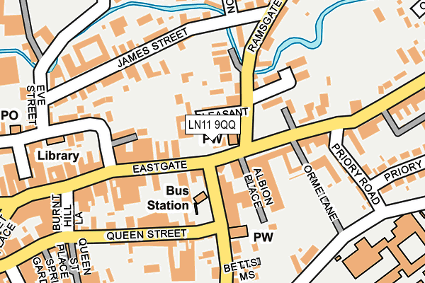
LN11 9QQ is located in the Priory & St James' electoral ward, within the local authority district of East Lindsey and the English Parliamentary constituency of Louth and Horncastle. The Sub Integrated Care Board (ICB) Location is NHS Lincolnshire ICB - 71E and the police force is Lincolnshire. This postcode has been in use since January 1980.


GetTheData
Source: OS OpenMap – Local (Ordnance Survey)
Source: OS VectorMap District (Ordnance Survey)
Licence: Open Government Licence (requires attribution)
| Easting | 533193 |
| Northing | 387519 |
| Latitude | 53.367759 |
| Longitude | 0.000330 |
GetTheData
Source: Open Postcode Geo
Licence: Open Government Licence
| Country | England |
| Postcode District | LN11 |
➜ See where LN11 is on a map ➜ Where is Louth? | |
GetTheData
Source: Land Registry Price Paid Data
Licence: Open Government Licence
Elevation or altitude of LN11 9QQ as distance above sea level:
| Metres | Feet | |
|---|---|---|
| Elevation | 20m | 66ft |
Elevation is measured from the approximate centre of the postcode, to the nearest point on an OS contour line from OS Terrain 50, which has contour spacing of ten vertical metres.
➜ How high above sea level am I? Find the elevation of your current position using your device's GPS.
GetTheData
Source: Open Postcode Elevation
Licence: Open Government Licence
| Ward | Priory & St James' |
| Constituency | Louth And Horncastle |
GetTheData
Source: ONS Postcode Database
Licence: Open Government Licence
| Pleasant Place (Ramsgate) | Louth | 46m |
| Pleasant Place (Ramsgate) | Louth | 61m |
| Bus Station (Church Street) | Louth | 96m |
| Priory Road (Eastgate) | Louth | 123m |
| Monks Dyke Technology College (Monks Dyke Road) | Louth | 229m |
GetTheData
Source: NaPTAN
Licence: Open Government Licence
GetTheData
Source: ONS Postcode Database
Licence: Open Government Licence


➜ Get more ratings from the Food Standards Agency
GetTheData
Source: Food Standards Agency
Licence: FSA terms & conditions
| Last Collection | |||
|---|---|---|---|
| Location | Mon-Fri | Sat | Distance |
| Pack Horse | 17:30 | 12:00 | 259m |
| Louth Market Place | 17:30 | 12:15 | 369m |
| Trinity Post Office | 17:15 | 11:30 | 407m |
GetTheData
Source: Dracos
Licence: Creative Commons Attribution-ShareAlike
The below table lists the International Territorial Level (ITL) codes (formerly Nomenclature of Territorial Units for Statistics (NUTS) codes) and Local Administrative Units (LAU) codes for LN11 9QQ:
| ITL 1 Code | Name |
|---|---|
| TLF | East Midlands (England) |
| ITL 2 Code | Name |
| TLF3 | Lincolnshire |
| ITL 3 Code | Name |
| TLF30 | Lincolnshire CC |
| LAU 1 Code | Name |
| E07000137 | East Lindsey |
GetTheData
Source: ONS Postcode Directory
Licence: Open Government Licence
The below table lists the Census Output Area (OA), Lower Layer Super Output Area (LSOA), and Middle Layer Super Output Area (MSOA) for LN11 9QQ:
| Code | Name | |
|---|---|---|
| OA | E00132422 | |
| LSOA | E01032986 | East Lindsey 004D |
| MSOA | E02005427 | East Lindsey 004 |
GetTheData
Source: ONS Postcode Directory
Licence: Open Government Licence
| LN11 0NA | Pleasant Place | 44m |
| LN11 9AB | Eastgate | 45m |
| LN11 9BW | Church Street | 54m |
| LN11 0NB | Ramsgate | 88m |
| LN11 9QE | Eastgate | 91m |
| LN11 9AA | Eastgate | 135m |
| LN11 0JW | James Street | 135m |
| LN11 0ND | Alexandra Road | 144m |
| LN11 9AY | Windsor Mews | 151m |
| LN11 0HW | Kings Mews | 153m |
GetTheData
Source: Open Postcode Geo; Land Registry Price Paid Data
Licence: Open Government Licence