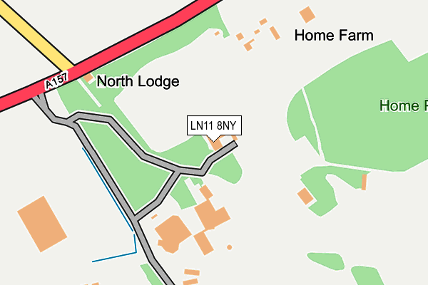
LN11 8NY is located in the Legbourne electoral ward, within the local authority district of East Lindsey and the English Parliamentary constituency of Louth and Horncastle. The Sub Integrated Care Board (ICB) Location is NHS Lincolnshire ICB - 71E and the police force is Lincolnshire. This postcode has been in use since January 1992.


GetTheData
Source: OS OpenMap – Local (Ordnance Survey)
Source: OS VectorMap District (Ordnance Survey)
Licence: Open Government Licence (requires attribution)
| Easting | 534554 |
| Northing | 385009 |
| Latitude | 53.344867 |
| Longitude | 0.019704 |
GetTheData
Source: Open Postcode Geo
Licence: Open Government Licence
| Country | England |
| Postcode District | LN11 |
➜ See where LN11 is on a map | |
GetTheData
Source: Land Registry Price Paid Data
Licence: Open Government Licence
Elevation or altitude of LN11 8NY as distance above sea level:
| Metres | Feet | |
|---|---|---|
| Elevation | 50m | 164ft |
Elevation is measured from the approximate centre of the postcode, to the nearest point on an OS contour line from OS Terrain 50, which has contour spacing of ten vertical metres.
➜ How high above sea level am I? Find the elevation of your current position using your device's GPS.
GetTheData
Source: Open Postcode Elevation
Licence: Open Government Licence
| Ward | Legbourne |
| Constituency | Louth And Horncastle |
GetTheData
Source: ONS Postcode Database
Licence: Open Government Licence
| Nutty Cottage (A157) | Kenwick Bar | 563m |
| Wyvale Garden Centre (Legbourne Road) | Louth | 890m |
| Wyvale Garden Centre (Legbourne Road) | Louth | 908m |
| Kai Mar (London Road) | Kenwick Bar | 1,264m |
| Kai Mar (London Road) | Kenwick Bar | 1,277m |
GetTheData
Source: NaPTAN
Licence: Open Government Licence
GetTheData
Source: ONS Postcode Database
Licence: Open Government Licence


➜ Get more ratings from the Food Standards Agency
GetTheData
Source: Food Standards Agency
Licence: FSA terms & conditions
| Last Collection | |||
|---|---|---|---|
| Location | Mon-Fri | Sat | Distance |
| Stewton Lane | 17:00 | 12:00 | 1,868m |
| Newmarket Post Office | 17:15 | 12:00 | 2,164m |
| Bluestone Rise | 16:15 | 11:30 | 2,544m |
GetTheData
Source: Dracos
Licence: Creative Commons Attribution-ShareAlike
The below table lists the International Territorial Level (ITL) codes (formerly Nomenclature of Territorial Units for Statistics (NUTS) codes) and Local Administrative Units (LAU) codes for LN11 8NY:
| ITL 1 Code | Name |
|---|---|
| TLF | East Midlands (England) |
| ITL 2 Code | Name |
| TLF3 | Lincolnshire |
| ITL 3 Code | Name |
| TLF30 | Lincolnshire CC |
| LAU 1 Code | Name |
| E07000137 | East Lindsey |
GetTheData
Source: ONS Postcode Directory
Licence: Open Government Licence
The below table lists the Census Output Area (OA), Lower Layer Super Output Area (LSOA), and Middle Layer Super Output Area (MSOA) for LN11 8NY:
| Code | Name | |
|---|---|---|
| OA | E00132306 | |
| LSOA | E01026070 | East Lindsey 009C |
| MSOA | E02005432 | East Lindsey 009 |
GetTheData
Source: ONS Postcode Directory
Licence: Open Government Licence
| LN11 8NN | Southfield Houses | 580m |
| LN11 8LQ | Legbourne Road | 682m |
| LN11 8NP | 1023m | |
| LN11 8NR | Kenwick Fairways Village | 1069m |
| LN11 8NL | Kenwick Road | 1216m |
| LN11 8QH | London Road | 1250m |
| LN11 8EZ | Kenwick Gardens | 1319m |
| LN11 8NS | Planting Side | 1324m |
| LN11 8EP | Kenwick Close | 1359m |
| LN11 8EN | Kenwick Road | 1370m |
GetTheData
Source: Open Postcode Geo; Land Registry Price Paid Data
Licence: Open Government Licence