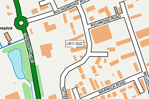
LN11 0UZ is located in the North Holme electoral ward, within the local authority district of East Lindsey and the English Parliamentary constituency of Louth and Horncastle. The Sub Integrated Care Board (ICB) Location is NHS Lincolnshire ICB - 71E and the police force is Lincolnshire. This postcode has been in use since May 2009.


GetTheData
Source: OS OpenMap – Local (Ordnance Survey)
Source: OS VectorMap District (Ordnance Survey)
Licence: Open Government Licence (requires attribution)
| Easting | 532467 |
| Northing | 389012 |
| Latitude | 53.381378 |
| Longitude | -0.009950 |
GetTheData
Source: Open Postcode Geo
Licence: Open Government Licence
| Country | England |
| Postcode District | LN11 |
➜ See where LN11 is on a map ➜ Where is Louth? | |
GetTheData
Source: Land Registry Price Paid Data
Licence: Open Government Licence
Elevation or altitude of LN11 0UZ as distance above sea level:
| Metres | Feet | |
|---|---|---|
| Elevation | 40m | 131ft |
Elevation is measured from the approximate centre of the postcode, to the nearest point on an OS contour line from OS Terrain 50, which has contour spacing of ten vertical metres.
➜ How high above sea level am I? Find the elevation of your current position using your device's GPS.
GetTheData
Source: Open Postcode Elevation
Licence: Open Government Licence
| Ward | North Holme |
| Constituency | Louth And Horncastle |
GetTheData
Source: ONS Postcode Database
Licence: Open Government Licence
| Milford Court (Warwick Road) | Louth | 221m |
| Lady Of Shallot Ph (Grimsby Road) | Louth | 627m |
| Blenheim Close (Arundel Drive) | Louth | 693m |
| Blenheim Close (Arundel Drive) | Louth | 737m |
| Harewood Crescent (Chatsworth Drive) | Louth | 792m |
GetTheData
Source: NaPTAN
Licence: Open Government Licence
GetTheData
Source: ONS Postcode Database
Licence: Open Government Licence


➜ Get more ratings from the Food Standards Agency
GetTheData
Source: Food Standards Agency
Licence: FSA terms & conditions
| Last Collection | |||
|---|---|---|---|
| Location | Mon-Fri | Sat | Distance |
| Brackenborough Road P.o. | 17:00 | 11:15 | 1,125m |
| Newbridge Hill | 17:30 | 11:15 | 1,265m |
| Pack Horse | 17:30 | 12:00 | 1,625m |
GetTheData
Source: Dracos
Licence: Creative Commons Attribution-ShareAlike
The below table lists the International Territorial Level (ITL) codes (formerly Nomenclature of Territorial Units for Statistics (NUTS) codes) and Local Administrative Units (LAU) codes for LN11 0UZ:
| ITL 1 Code | Name |
|---|---|
| TLF | East Midlands (England) |
| ITL 2 Code | Name |
| TLF3 | Lincolnshire |
| ITL 3 Code | Name |
| TLF30 | Lincolnshire CC |
| LAU 1 Code | Name |
| E07000137 | East Lindsey |
GetTheData
Source: ONS Postcode Directory
Licence: Open Government Licence
The below table lists the Census Output Area (OA), Lower Layer Super Output Area (LSOA), and Middle Layer Super Output Area (MSOA) for LN11 0UZ:
| Code | Name | |
|---|---|---|
| OA | E00132364 | |
| LSOA | E01026077 | East Lindsey 003A |
| MSOA | E02005426 | East Lindsey 003 |
GetTheData
Source: ONS Postcode Directory
Licence: Open Government Licence
| LN11 0YZ | Tattershall Way | 221m |
| LN11 0YB | Warwick Road | 228m |
| LN11 0WA | Bolingbroke Road | 257m |
| LN11 0SX | Grimsby Road | 327m |
| LN11 0WB | Nottingham Road | 346m |
| LN11 0LQ | Belvoir Way | 478m |
| LN11 0HY | Hardwick Close | 609m |
| LN11 0HT | Burghley Crescent | 680m |
| LN11 0HX | Blenheim Close | 683m |
| LN11 0YX | Althorp Gardens | 689m |
GetTheData
Source: Open Postcode Geo; Land Registry Price Paid Data
Licence: Open Government Licence