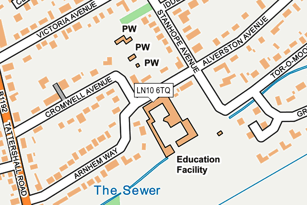
LN10 6TQ is located in the Woodhall Spa electoral ward, within the local authority district of East Lindsey and the English Parliamentary constituency of Louth and Horncastle. The Sub Integrated Care Board (ICB) Location is NHS Lincolnshire ICB - 71E and the police force is Lincolnshire. This postcode has been in use since January 1980.


GetTheData
Source: OS OpenMap – Local (Ordnance Survey)
Source: OS VectorMap District (Ordnance Survey)
Licence: Open Government Licence (requires attribution)
| Easting | 519593 |
| Northing | 362853 |
| Latitude | 53.149400 |
| Longitude | -0.213213 |
GetTheData
Source: Open Postcode Geo
Licence: Open Government Licence
| Country | England |
| Postcode District | LN10 |
➜ See where LN10 is on a map ➜ Where is Woodhall Spa? | |
GetTheData
Source: Land Registry Price Paid Data
Licence: Open Government Licence
Elevation or altitude of LN10 6TQ as distance above sea level:
| Metres | Feet | |
|---|---|---|
| Elevation | 10m | 33ft |
Elevation is measured from the approximate centre of the postcode, to the nearest point on an OS contour line from OS Terrain 50, which has contour spacing of ten vertical metres.
➜ How high above sea level am I? Find the elevation of your current position using your device's GPS.
GetTheData
Source: Open Postcode Elevation
Licence: Open Government Licence
| Ward | Woodhall Spa |
| Constituency | Louth And Horncastle |
GetTheData
Source: ONS Postcode Database
Licence: Open Government Licence
| Iddesleigh Road (Stanhope Avenue) | Woodhall Spa | 165m |
| Grove Drive (Tor-o-moor Road) | Woodhall Spa | 178m |
| Iddesleigh Road (Stanhope Avenue) | Woodhall Spa | 190m |
| Grove Drive (Tor-o-moor Road) | Woodhall Spa | 208m |
| Long Avenue (Tattershall Road) | Woodhall Spa | 288m |
GetTheData
Source: NaPTAN
Licence: Open Government Licence
GetTheData
Source: ONS Postcode Database
Licence: Open Government Licence


➜ Get more ratings from the Food Standards Agency
GetTheData
Source: Food Standards Agency
Licence: FSA terms & conditions
| Last Collection | |||
|---|---|---|---|
| Location | Mon-Fri | Sat | Distance |
| Alverstone Avenue | 17:00 | 08:00 | 122m |
| Cromwell Avenue | 17:00 | 11:00 | 264m |
| Woodhall Spa Post Office | 17:30 | 12:00 | 304m |
GetTheData
Source: Dracos
Licence: Creative Commons Attribution-ShareAlike
The below table lists the International Territorial Level (ITL) codes (formerly Nomenclature of Territorial Units for Statistics (NUTS) codes) and Local Administrative Units (LAU) codes for LN10 6TQ:
| ITL 1 Code | Name |
|---|---|
| TLF | East Midlands (England) |
| ITL 2 Code | Name |
| TLF3 | Lincolnshire |
| ITL 3 Code | Name |
| TLF30 | Lincolnshire CC |
| LAU 1 Code | Name |
| E07000137 | East Lindsey |
GetTheData
Source: ONS Postcode Directory
Licence: Open Government Licence
The below table lists the Census Output Area (OA), Lower Layer Super Output Area (LSOA), and Middle Layer Super Output Area (MSOA) for LN10 6TQ:
| Code | Name | |
|---|---|---|
| OA | E00132616 | |
| LSOA | E01026119 | East Lindsey 016F |
| MSOA | E02005439 | East Lindsey 016 |
GetTheData
Source: ONS Postcode Directory
Licence: Open Government Licence
| LN10 6TH | Cromwell Avenue | 133m |
| LN10 6TJ | Arnhem Way | 154m |
| LN10 6TG | Stanhope Avenue | 158m |
| LN10 6SP | Stanhope Avenue | 181m |
| LN10 6TY | Victoria Avenue | 214m |
| LN10 6RS | Kirkstead Court | 218m |
| LN10 6TF | Tor O Moor Road | 253m |
| LN10 6TN | Tattershall Road | 264m |
| LN10 6TW | Tattershall Road | 269m |
| LN10 6SN | Alverston Avenue | 285m |
GetTheData
Source: Open Postcode Geo; Land Registry Price Paid Data
Licence: Open Government Licence