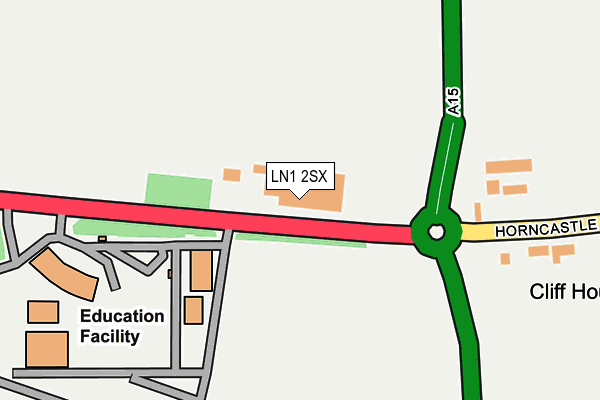
LN1 2SX is located in the Scampton electoral ward, within the local authority district of West Lindsey and the English Parliamentary constituency of Gainsborough. The Sub Integrated Care Board (ICB) Location is NHS Lincolnshire ICB - 71E and the police force is Lincolnshire. This postcode has been in use since July 1995.


GetTheData
Source: OS OpenMap – Local (Ordnance Survey)
Source: OS VectorMap District (Ordnance Survey)
Licence: Open Government Licence (requires attribution)
| Easting | 497203 |
| Northing | 378157 |
| Latitude | 53.291494 |
| Longitude | -0.543216 |
GetTheData
Source: Open Postcode Geo
Licence: Open Government Licence
| Country | England |
| Postcode District | LN1 |
➜ See where LN1 is on a map | |
GetTheData
Source: Land Registry Price Paid Data
Licence: Open Government Licence
Elevation or altitude of LN1 2SX as distance above sea level:
| Metres | Feet | |
|---|---|---|
| Elevation | 50m | 164ft |
Elevation is measured from the approximate centre of the postcode, to the nearest point on an OS contour line from OS Terrain 50, which has contour spacing of ten vertical metres.
➜ How high above sea level am I? Find the elevation of your current position using your device's GPS.
GetTheData
Source: Open Postcode Elevation
Licence: Open Government Licence
| Ward | Scampton |
| Constituency | Gainsborough |
GetTheData
Source: ONS Postcode Database
Licence: Open Government Licence
| Tillbridge Lane (Horncastle Lane) | Lincolnshire Showground | 276m |
| Tennis Courts (Gibson Drive) | Scampton Raf | 655m |
| Lincolnshire Showground (A15) | Lincolnshire Showground | 658m |
| Lincolnshire Showground (A15) | Lincolnshire Showground | 680m |
| Watering Dyke Houses (Hall Lane) | Grange De Lings | 978m |
GetTheData
Source: NaPTAN
Licence: Open Government Licence
GetTheData
Source: ONS Postcode Database
Licence: Open Government Licence

➜ Get more ratings from the Food Standards Agency
GetTheData
Source: Food Standards Agency
Licence: FSA terms & conditions
| Last Collection | |||
|---|---|---|---|
| Location | Mon-Fri | Sat | Distance |
| Scampton Post Office | 16:45 | 11:30 | 1,028m |
| Raf Scampton Post Office | 17:00 | 11:15 | 2,255m |
| South Carlton | 17:15 | 12:15 | 2,578m |
GetTheData
Source: Dracos
Licence: Creative Commons Attribution-ShareAlike
The below table lists the International Territorial Level (ITL) codes (formerly Nomenclature of Territorial Units for Statistics (NUTS) codes) and Local Administrative Units (LAU) codes for LN1 2SX:
| ITL 1 Code | Name |
|---|---|
| TLF | East Midlands (England) |
| ITL 2 Code | Name |
| TLF3 | Lincolnshire |
| ITL 3 Code | Name |
| TLF30 | Lincolnshire CC |
| LAU 1 Code | Name |
| E07000142 | West Lindsey |
GetTheData
Source: ONS Postcode Directory
Licence: Open Government Licence
The below table lists the Census Output Area (OA), Lower Layer Super Output Area (LSOA), and Middle Layer Super Output Area (MSOA) for LN1 2SX:
| Code | Name | |
|---|---|---|
| OA | E00134134 | |
| LSOA | E01026400 | West Lindsey 009D |
| MSOA | E02005500 | West Lindsey 009 |
GetTheData
Source: ONS Postcode Directory
Licence: Open Government Licence
| LN1 2ZF | Woodlands Edge | 573m |
| LN1 2TA | Trenchard Square | 702m |
| LN1 2SZ | Horncastle Lane | 859m |
| LN1 2UR | Whitley Street | 877m |
| LN1 2UX | Second Avenue | 881m |
| LN1 2TH | Wellington Street | 882m |
| LN1 2UU | Hampden Street | 919m |
| LN2 2LZ | Brigg Road | 942m |
| LN1 2UL | Sussex Gardens | 963m |
| LN1 2TL | Pollyplatt Lane | 970m |
GetTheData
Source: Open Postcode Geo; Land Registry Price Paid Data
Licence: Open Government Licence