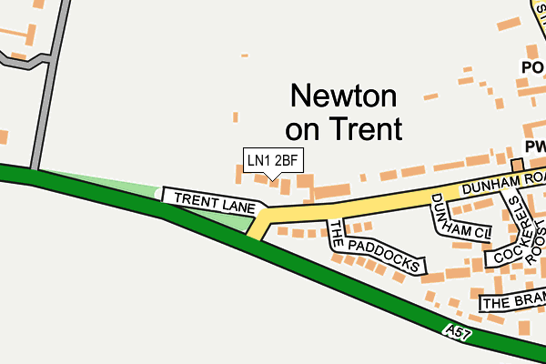
LN1 2BF lies on Trent Lane in Newton On Trent, Lincoln. LN1 2BF is located in the Torksey electoral ward, within the local authority district of West Lindsey and the English Parliamentary constituency of Gainsborough. The Sub Integrated Care Board (ICB) Location is NHS Lincolnshire ICB - 71E and the police force is Lincolnshire. This postcode has been in use since December 1998.


GetTheData
Source: OS OpenMap – Local (Ordnance Survey)
Source: OS VectorMap District (Ordnance Survey)
Licence: Open Government Licence (requires attribution)
| Easting | 482919 |
| Northing | 374224 |
| Latitude | 53.258551 |
| Longitude | -0.758469 |
GetTheData
Source: Open Postcode Geo
Licence: Open Government Licence
| Street | Trent Lane |
| Locality | Newton On Trent |
| Town/City | Lincoln |
| Country | England |
| Postcode District | LN1 |
➜ See where LN1 is on a map ➜ Where is Newton on Trent? | |
GetTheData
Source: Land Registry Price Paid Data
Licence: Open Government Licence
Elevation or altitude of LN1 2BF as distance above sea level:
| Metres | Feet | |
|---|---|---|
| Elevation | 10m | 33ft |
Elevation is measured from the approximate centre of the postcode, to the nearest point on an OS contour line from OS Terrain 50, which has contour spacing of ten vertical metres.
➜ How high above sea level am I? Find the elevation of your current position using your device's GPS.
GetTheData
Source: Open Postcode Elevation
Licence: Open Government Licence
| Ward | Torksey |
| Constituency | Gainsborough |
GetTheData
Source: ONS Postcode Database
Licence: Open Government Licence
| Dunham Close (Dunham Road) | Newton On Trent | 159m |
| Dunham Close (Dunham Road) | Newton On Trent | 185m |
| Demand Responsive Area | Newton On Trent | 284m |
| Demand Responsive Area | Laughterton | 1,638m |
GetTheData
Source: NaPTAN
Licence: Open Government Licence
| Percentage of properties with Next Generation Access | 100.0% |
| Percentage of properties with Superfast Broadband | 100.0% |
| Percentage of properties with Ultrafast Broadband | 0.0% |
| Percentage of properties with Full Fibre Broadband | 0.0% |
Superfast Broadband is between 30Mbps and 300Mbps
Ultrafast Broadband is > 300Mbps
| Percentage of properties unable to receive 2Mbps | 0.0% |
| Percentage of properties unable to receive 5Mbps | 0.0% |
| Percentage of properties unable to receive 10Mbps | 0.0% |
| Percentage of properties unable to receive 30Mbps | 0.0% |
GetTheData
Source: Ofcom
Licence: Ofcom Terms of Use (requires attribution)
GetTheData
Source: ONS Postcode Database
Licence: Open Government Licence


➜ Get more ratings from the Food Standards Agency
GetTheData
Source: Food Standards Agency
Licence: FSA terms & conditions
| Last Collection | |||
|---|---|---|---|
| Location | Mon-Fri | Sat | Distance |
| North Clifton | 16:00 | 09:30 | 2,146m |
| Church Laneham | 16:30 | 11:00 | 2,824m |
| Thorney | 16:00 | 10:00 | 3,207m |
GetTheData
Source: Dracos
Licence: Creative Commons Attribution-ShareAlike
| Risk of LN1 2BF flooding from rivers and sea | Low |
| ➜ LN1 2BF flood map | |
GetTheData
Source: Open Flood Risk by Postcode
Licence: Open Government Licence
The below table lists the International Territorial Level (ITL) codes (formerly Nomenclature of Territorial Units for Statistics (NUTS) codes) and Local Administrative Units (LAU) codes for LN1 2BF:
| ITL 1 Code | Name |
|---|---|
| TLF | East Midlands (England) |
| ITL 2 Code | Name |
| TLF3 | Lincolnshire |
| ITL 3 Code | Name |
| TLF30 | Lincolnshire CC |
| LAU 1 Code | Name |
| E07000142 | West Lindsey |
GetTheData
Source: ONS Postcode Directory
Licence: Open Government Licence
The below table lists the Census Output Area (OA), Lower Layer Super Output Area (LSOA), and Middle Layer Super Output Area (MSOA) for LN1 2BF:
| Code | Name | |
|---|---|---|
| OA | E00134179 | |
| LSOA | E01026409 | West Lindsey 007C |
| MSOA | E02005498 | West Lindsey 007 |
GetTheData
Source: ONS Postcode Directory
Licence: Open Government Licence
| LN1 2JR | Dunham Road | 81m |
| LN1 2JG | The Paddocks | 151m |
| LN1 2YU | The Brambles | 278m |
| LN1 2FY | Cockerels Roost | 283m |
| LN1 2JS | High Street | 371m |
| LN1 2JP | High Street | 379m |
| LN1 2GJ | Orchard Close | 413m |
| LN1 2NN | The Grove | 420m |
| LN1 2WF | Church Yard | 463m |
| LN1 2LL | Collingham Road | 470m |
GetTheData
Source: Open Postcode Geo; Land Registry Price Paid Data
Licence: Open Government Licence