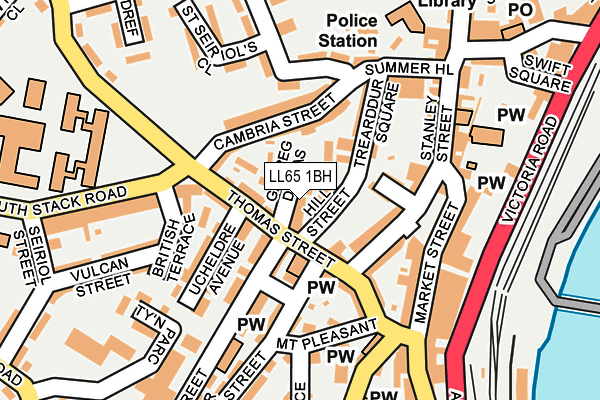
LL65 1BH is located in the Tref Cybi electoral ward, within the unitary authority of Isle of Anglesey and the Welsh Parliamentary constituency of Ynys M�n. The Local Health Board is Betsi Cadwaladr University and the police force is North Wales. This postcode has been in use since March 2017.


GetTheData
Source: OS OpenMap – Local (Ordnance Survey)
Source: OS VectorMap District (Ordnance Survey)
Licence: Open Government Licence (requires attribution)
| Easting | 224530 |
| Northing | 382557 |
| Latitude | 53.310816 |
| Longitude | -4.635253 |
GetTheData
Source: Open Postcode Geo
Licence: Open Government Licence
| Country | Wales |
| Postcode District | LL65 |
➜ See where LL65 is on a map ➜ Where is Holyhead? | |
GetTheData
Source: Land Registry Price Paid Data
Licence: Open Government Licence
| Ward | Tref Cybi |
| Constituency | Ynys M�n |
GetTheData
Source: ONS Postcode Database
Licence: Open Government Licence
| Hill Street Car Park (Hill Street) | Holyhead | 22m |
| British Terrace (Alderley Terrace) | Holyhead | 155m |
| Summer Hill | Holyhead | 182m |
| Clock (Victoria Terrace) | Holyhead | 235m |
| Ysgol Ganradd Caergybi (Porth-y-felin Road) | Porth-y-felin | 269m |
| Holyhead Station | 0.4km |
| Valley Station | 5.8km |
GetTheData
Source: NaPTAN
Licence: Open Government Licence
| Percentage of properties with Next Generation Access | 100.0% |
| Percentage of properties with Superfast Broadband | 100.0% |
| Percentage of properties with Ultrafast Broadband | 0.0% |
| Percentage of properties with Full Fibre Broadband | 0.0% |
Superfast Broadband is between 30Mbps and 300Mbps
Ultrafast Broadband is > 300Mbps
| Percentage of properties unable to receive 2Mbps | 0.0% |
| Percentage of properties unable to receive 5Mbps | 0.0% |
| Percentage of properties unable to receive 10Mbps | 0.0% |
| Percentage of properties unable to receive 30Mbps | 0.0% |
GetTheData
Source: Ofcom
Licence: Ofcom Terms of Use (requires attribution)
GetTheData
Source: ONS Postcode Database
Licence: Open Government Licence


➜ Get more ratings from the Food Standards Agency
GetTheData
Source: Food Standards Agency
Licence: FSA terms & conditions
| Last Collection | |||
|---|---|---|---|
| Location | Mon-Fri | Sat | Distance |
| Gors | 16:00 | 11:45 | 675m |
| Morrison's | 17:30 | 12:30 | 3,052m |
| Market Street | 17:00 | 11:45 | 4,238m |
GetTheData
Source: Dracos
Licence: Creative Commons Attribution-ShareAlike
The below table lists the International Territorial Level (ITL) codes (formerly Nomenclature of Territorial Units for Statistics (NUTS) codes) and Local Administrative Units (LAU) codes for LL65 1BH:
| ITL 1 Code | Name |
|---|---|
| TLL | Wales |
| ITL 2 Code | Name |
| TLL1 | West Wales and The Valleys |
| ITL 3 Code | Name |
| TLL11 | Isle of Anglesey |
| LAU 1 Code | Name |
| W06000001 | Isle of Anglesey |
GetTheData
Source: ONS Postcode Directory
Licence: Open Government Licence
The below table lists the Census Output Area (OA), Lower Layer Super Output Area (LSOA), and Middle Layer Super Output Area (MSOA) for LL65 1BH:
| Code | Name | |
|---|---|---|
| OA | W00000075 | |
| LSOA | W01000016 | Isle of Anglesey 003A |
| MSOA | W02000003 | Isle of Anglesey 003 |
GetTheData
Source: ONS Postcode Directory
Licence: Open Government Licence
| LL65 1RT | Garreg Domas | 15m |
| LL65 1ND | Hill Street | 24m |
| LL65 1NE | Hill Street | 54m |
| LL65 1RS | Thomas Street | 54m |
| LL65 1NH | Cambria Street | 72m |
| LL65 1RW | Tower Gardens | 81m |
| LL65 1RN | William Street | 89m |
| LL65 1RR | Thomas Street | 101m |
| LL65 1NB | Trearddur Square | 102m |
| LL65 1RU | Ucheldre Avenue | 118m |
GetTheData
Source: Open Postcode Geo; Land Registry Price Paid Data
Licence: Open Government Licence