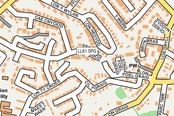
LL61 5PG is located in the Aethwy electoral ward, within the unitary authority of Isle of Anglesey and the Welsh Parliamentary constituency of Ynys M�n. The Local Health Board is Betsi Cadwaladr University and the police force is North Wales. This postcode has been in use since October 2007.


GetTheData
Source: OS OpenMap – Local (Ordnance Survey)
Source: OS VectorMap District (Ordnance Survey)
Licence: Open Government Licence (requires attribution)
| Easting | 253225 |
| Northing | 371815 |
| Latitude | 53.223065 |
| Longitude | -4.199967 |
GetTheData
Source: Open Postcode Geo
Licence: Open Government Licence
| Country | Wales |
| Postcode District | LL61 |
➜ See where LL61 is on a map ➜ Where is Llanfair Pwllgwyngyll? | |
GetTheData
Source: Land Registry Price Paid Data
Licence: Open Government Licence
Elevation or altitude of LL61 5PG as distance above sea level:
| Metres | Feet | |
|---|---|---|
| Elevation | 30m | 98ft |
Elevation is measured from the approximate centre of the postcode, to the nearest point on an OS contour line from OS Terrain 50, which has contour spacing of ten vertical metres.
➜ How high above sea level am I? Find the elevation of your current position using your device's GPS.
GetTheData
Source: Open Postcode Elevation
Licence: Open Government Licence
| Ward | Aethwy |
| Constituency | Ynys M�n |
GetTheData
Source: ONS Postcode Database
Licence: Open Government Licence
| Cil Y Graig (Lon Ty Croes) | Llanfairpwllgwyngyll | 69m |
| Cil Y Graig (Lon Ty Croes) | Llanfairpwllgwyngyll | 75m |
| Trem Yr Eryri (Lon Ty Croes) | Llanfairpwllgwyngyll | 140m |
| Trem Yr Eryri (Lon Ty Croes) | Llanfairpwllgwyngyll | 183m |
| Bryn Bras (Lon Dryll) | Llanfairpwllgwyngyll | 243m |
| Llanfairpwll Station | 0.7km |
| Bangor (Gwynedd) Station | 4.3km |
GetTheData
Source: NaPTAN
Licence: Open Government Licence
GetTheData
Source: ONS Postcode Database
Licence: Open Government Licence


➜ Get more ratings from the Food Standards Agency
GetTheData
Source: Food Standards Agency
Licence: FSA terms & conditions
| Last Collection | |||
|---|---|---|---|
| Location | Mon-Fri | Sat | Distance |
| Upper Village | 09:00 | 08:00 | 224m |
| Siglan | 09:00 | 08:00 | 318m |
| Llanfairpwll Post Office | 17:30 | 11:30 | 471m |
GetTheData
Source: Dracos
Licence: Creative Commons Attribution-ShareAlike
The below table lists the International Territorial Level (ITL) codes (formerly Nomenclature of Territorial Units for Statistics (NUTS) codes) and Local Administrative Units (LAU) codes for LL61 5PG:
| ITL 1 Code | Name |
|---|---|
| TLL | Wales |
| ITL 2 Code | Name |
| TLL1 | West Wales and The Valleys |
| ITL 3 Code | Name |
| TLL11 | Isle of Anglesey |
| LAU 1 Code | Name |
| W06000001 | Isle of Anglesey |
GetTheData
Source: ONS Postcode Directory
Licence: Open Government Licence
The below table lists the Census Output Area (OA), Lower Layer Super Output Area (LSOA), and Middle Layer Super Output Area (MSOA) for LL61 5PG:
| Code | Name | |
|---|---|---|
| OA | W00000070 | |
| LSOA | W01000015 | Isle of Anglesey 008C |
| MSOA | W02000008 | Isle of Anglesey 008 |
GetTheData
Source: ONS Postcode Directory
Licence: Open Government Licence
| LL61 5RZ | Stad Foel Graig | 73m |
| LL61 5JY | Lon Hedydd | 96m |
| LL61 5RA | Lon Foel Graig | 112m |
| LL61 5NZ | Cil Y Graig | 118m |
| LL61 5JR | Stad Ty Croes | 163m |
| LL61 5JS | Cae Cnyciog | 191m |
| LL61 5JL | 196m | |
| LL61 5RQ | 201m | |
| LL61 5AQ | Y Wern | 216m |
| LL61 5PX | Bryn Bras Estate | 219m |
GetTheData
Source: Open Postcode Geo; Land Registry Price Paid Data
Licence: Open Government Licence