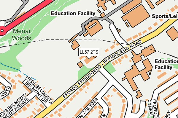
LL57 2TS is located in the Glyder electoral ward, within the unitary authority of Gwynedd and the Welsh Parliamentary constituency of Arfon. The Local Health Board is Betsi Cadwaladr University and the police force is North Wales. This postcode has been in use since January 1980.


GetTheData
Source: OS OpenMap – Local (Ordnance Survey)
Source: OS VectorMap District (Ordnance Survey)
Licence: Open Government Licence (requires attribution)
| Easting | 256978 |
| Northing | 371744 |
| Latitude | 53.223434 |
| Longitude | -4.143757 |
GetTheData
Source: Open Postcode Geo
Licence: Open Government Licence
| Country | Wales |
| Postcode District | LL57 |
➜ See where LL57 is on a map ➜ Where is Bangor? | |
GetTheData
Source: Land Registry Price Paid Data
Licence: Open Government Licence
Elevation or altitude of LL57 2TS as distance above sea level:
| Metres | Feet | |
|---|---|---|
| Elevation | 70m | 230ft |
Elevation is measured from the approximate centre of the postcode, to the nearest point on an OS contour line from OS Terrain 50, which has contour spacing of ten vertical metres.
➜ How high above sea level am I? Find the elevation of your current position using your device's GPS.
GetTheData
Source: Open Postcode Elevation
Licence: Open Government Licence
| Ward | Glyder |
| Constituency | Arfon |
GetTheData
Source: ONS Postcode Database
Licence: Open Government Licence
| Coleg Menai (Ffriddoedd Road) | Upper Bangor | 39m |
| Coleg Menai (Ffriddoedd Road) | Upper Bangor | 48m |
| Swyddfa'r Post Office (Ffriddoedd Road) | Bangor | 220m |
| Swyddfa'r Post Office (Ffriddoedd Road) | Bangor | 231m |
| Canolfan Hamdden (Ffriddoedd Road) | Upper Bangor | 256m |
| Bangor (Gwynedd) Station | 0.5km |
| Llanfairpwll Station | 4.4km |
GetTheData
Source: NaPTAN
Licence: Open Government Licence
GetTheData
Source: ONS Postcode Database
Licence: Open Government Licence


➜ Get more ratings from the Food Standards Agency
GetTheData
Source: Food Standards Agency
Licence: FSA terms & conditions
| Last Collection | |||
|---|---|---|---|
| Location | Mon-Fri | Sat | Distance |
| Old Friars School | 17:15 | 11:30 | 52m |
| Victoria Park | 17:30 | 11:34 | 505m |
| Georges Crossing Menai Bridge | 11:00 | 10:00 | 544m |
GetTheData
Source: Dracos
Licence: Creative Commons Attribution-ShareAlike
The below table lists the International Territorial Level (ITL) codes (formerly Nomenclature of Territorial Units for Statistics (NUTS) codes) and Local Administrative Units (LAU) codes for LL57 2TS:
| ITL 1 Code | Name |
|---|---|
| TLL | Wales |
| ITL 2 Code | Name |
| TLL1 | West Wales and The Valleys |
| ITL 3 Code | Name |
| TLL12 | Gwynedd |
| LAU 1 Code | Name |
| W06000002 | Gwynedd |
GetTheData
Source: ONS Postcode Directory
Licence: Open Government Licence
The below table lists the Census Output Area (OA), Lower Layer Super Output Area (LSOA), and Middle Layer Super Output Area (MSOA) for LL57 2TS:
| Code | Name | |
|---|---|---|
| OA | W00000372 | |
| LSOA | W01000072 | Gwynedd 002B |
| MSOA | W02000011 | Gwynedd 002 |
GetTheData
Source: ONS Postcode Directory
Licence: Open Government Licence
| LL57 2TW | Ffriddoedd Road | 177m |
| LL57 2UA | Lon Y Glyder | 186m |
| LL57 2HS | Belmont Drive | 199m |
| LL57 2TT | Ffriddoedd Road | 232m |
| LL57 2UD | Lon Ogwen | 236m |
| LL57 2UF | Trem Elidir | 265m |
| LL57 2TU | Lon Powys | 266m |
| LL57 2YU | Belmont Street | 266m |
| LL57 2YL | Ffordd Cynfal | 274m |
| LL57 2YS | Clarence Street | 302m |
GetTheData
Source: Open Postcode Geo; Land Registry Price Paid Data
Licence: Open Government Licence