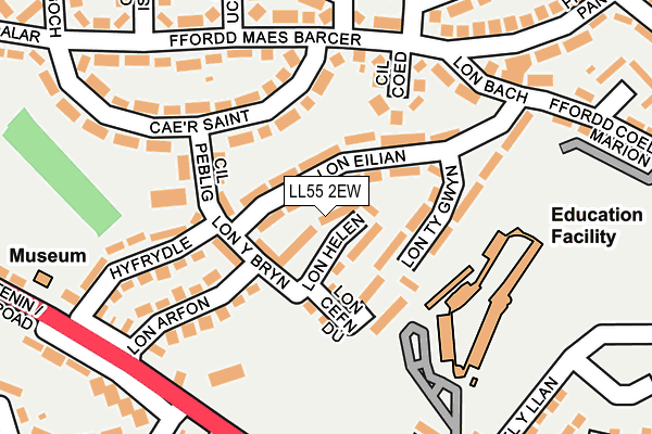
LL55 2EW lies on Lon Helen in Caernarfon. LL55 2EW is located in the Peblig electoral ward, within the unitary authority of Gwynedd and the Welsh Parliamentary constituency of Arfon. The Local Health Board is Betsi Cadwaladr University and the police force is North Wales. This postcode has been in use since January 1980.


GetTheData
Source: OS OpenMap – Local (Ordnance Survey)
Source: OS VectorMap District (Ordnance Survey)
Licence: Open Government Licence (requires attribution)
| Easting | 248836 |
| Northing | 362434 |
| Latitude | 53.137558 |
| Longitude | -4.261209 |
GetTheData
Source: Open Postcode Geo
Licence: Open Government Licence
| Street | Lon Helen |
| Town/City | Caernarfon |
| Country | Wales |
| Postcode District | LL55 |
➜ See where LL55 is on a map ➜ Where is Caernarfon? | |
GetTheData
Source: Land Registry Price Paid Data
Licence: Open Government Licence
Elevation or altitude of LL55 2EW as distance above sea level:
| Metres | Feet | |
|---|---|---|
| Elevation | 40m | 131ft |
Elevation is measured from the approximate centre of the postcode, to the nearest point on an OS contour line from OS Terrain 50, which has contour spacing of ten vertical metres.
➜ How high above sea level am I? Find the elevation of your current position using your device's GPS.
GetTheData
Source: Open Postcode Elevation
Licence: Open Government Licence
| Ward | Peblig |
| Constituency | Arfon |
GetTheData
Source: ONS Postcode Database
Licence: Open Government Licence
| Lon Eilian West (Lon Eilian) | Caernarfon | 34m |
| Noddfa (Cil Peblig) | Caernarfon | 120m |
| Lon Ty Gwyn (Lon Eilian) | Caernarfon | 157m |
| Cil Coed (Ffordd Maes Barcer) | Caernarfon | 175m |
| Cae`r Garreg (Llanberis Road) | Caernarfon | 217m |
| Caernarfon (Welsh Highland Rly-caernarfon) | Caernarfon | 710m |
GetTheData
Source: NaPTAN
Licence: Open Government Licence
| Percentage of properties with Next Generation Access | 100.0% |
| Percentage of properties with Superfast Broadband | 100.0% |
| Percentage of properties with Ultrafast Broadband | 0.0% |
| Percentage of properties with Full Fibre Broadband | 0.0% |
Superfast Broadband is between 30Mbps and 300Mbps
Ultrafast Broadband is > 300Mbps
| Median download speed | 22.8Mbps |
| Average download speed | 26.2Mbps |
| Maximum download speed | 59.22Mbps |
| Median upload speed | 2.5Mbps |
| Average upload speed | 3.3Mbps |
| Maximum upload speed | 8.71Mbps |
| Percentage of properties unable to receive 2Mbps | 0.0% |
| Percentage of properties unable to receive 5Mbps | 0.0% |
| Percentage of properties unable to receive 10Mbps | 0.0% |
| Percentage of properties unable to receive 30Mbps | 0.0% |
GetTheData
Source: Ofcom
Licence: Ofcom Terms of Use (requires attribution)
Estimated total energy consumption in LL55 2EW by fuel type, 2015.
| Consumption (kWh) | 158,220 |
|---|---|
| Meter count | 22 |
| Mean (kWh/meter) | 7,192 |
| Median (kWh/meter) | 6,808 |
| Consumption (kWh) | 51,096 |
|---|---|
| Meter count | 18 |
| Mean (kWh/meter) | 2,839 |
| Median (kWh/meter) | 2,538 |
GetTheData
Source: Postcode level gas estimates: 2015 (experimental)
Source: Postcode level electricity estimates: 2015 (experimental)
Licence: Open Government Licence
GetTheData
Source: ONS Postcode Database
Licence: Open Government Licence


➜ Get more ratings from the Food Standards Agency
GetTheData
Source: Food Standards Agency
Licence: FSA terms & conditions
| Last Collection | |||
|---|---|---|---|
| Location | Mon-Fri | Sat | Distance |
| Y Maes Box | 17:30 | 12:30 | 882m |
| Y Maes | 17:30 | 12:30 | 883m |
| Caernarfon Delivery Office | 17:30 | 13:00 | 1,251m |
GetTheData
Source: Dracos
Licence: Creative Commons Attribution-ShareAlike
The below table lists the International Territorial Level (ITL) codes (formerly Nomenclature of Territorial Units for Statistics (NUTS) codes) and Local Administrative Units (LAU) codes for LL55 2EW:
| ITL 1 Code | Name |
|---|---|
| TLL | Wales |
| ITL 2 Code | Name |
| TLL1 | West Wales and The Valleys |
| ITL 3 Code | Name |
| TLL12 | Gwynedd |
| LAU 1 Code | Name |
| W06000002 | Gwynedd |
GetTheData
Source: ONS Postcode Directory
Licence: Open Government Licence
The below table lists the Census Output Area (OA), Lower Layer Super Output Area (LSOA), and Middle Layer Super Output Area (MSOA) for LL55 2EW:
| Code | Name | |
|---|---|---|
| OA | W00000498 | |
| LSOA | W01000098 | Gwynedd 006C |
| MSOA | W02000015 | Gwynedd 006 |
GetTheData
Source: ONS Postcode Directory
Licence: Open Government Licence
| LL55 2EG | Lon Eilian | 55m |
| LL55 2EN | Lon Cefn Du | 86m |
| LL55 2EH | Lon Ty Gwyn | 87m |
| LL55 2DP | Cil Coed | 117m |
| LL55 2RT | Caer Saint | 129m |
| LL55 2RS | Cil Peblig | 135m |
| LL55 2ER | Lon Arfon | 141m |
| LL55 2EU | Hyfrydle | 173m |
| LL55 2DS | Lon Bach | 201m |
| LL55 2DL | Ffordd Maes Barcer | 215m |
GetTheData
Source: Open Postcode Geo; Land Registry Price Paid Data
Licence: Open Government Licence