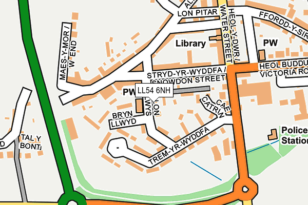
LL54 6NH lies on Lon Yr Eglwys in Penygroes, Caernarfon. LL54 6NH is located in the Pen-y-groes electoral ward, within the unitary authority of Gwynedd and the Welsh Parliamentary constituency of Arfon. The Local Health Board is Betsi Cadwaladr University and the police force is North Wales. This postcode has been in use since January 1980.


GetTheData
Source: OS OpenMap – Local (Ordnance Survey)
Source: OS VectorMap District (Ordnance Survey)
Licence: Open Government Licence (requires attribution)
| Easting | 246912 |
| Northing | 353005 |
| Latitude | 53.052318 |
| Longitude | -4.285451 |
GetTheData
Source: Open Postcode Geo
Licence: Open Government Licence
| Street | Lon Yr Eglwys |
| Locality | Penygroes |
| Town/City | Caernarfon |
| Country | Wales |
| Postcode District | LL54 |
➜ See where LL54 is on a map ➜ Where is Penygroes? | |
GetTheData
Source: Land Registry Price Paid Data
Licence: Open Government Licence
Elevation or altitude of LL54 6NH as distance above sea level:
| Metres | Feet | |
|---|---|---|
| Elevation | 100m | 328ft |
Elevation is measured from the approximate centre of the postcode, to the nearest point on an OS contour line from OS Terrain 50, which has contour spacing of ten vertical metres.
➜ How high above sea level am I? Find the elevation of your current position using your device's GPS.
GetTheData
Source: Open Postcode Elevation
Licence: Open Government Licence
| Ward | Pen-y-groes |
| Constituency | Arfon |
GetTheData
Source: ONS Postcode Database
Licence: Open Government Licence
2018 24 SEP £175,500 |
2003 14 NOV £135,000 |
1997 10 JUL £72,500 |
GetTheData
Source: HM Land Registry Price Paid Data
Licence: Contains HM Land Registry data © Crown copyright and database right 2024. This data is licensed under the Open Government Licence v3.0.
| Co-op (Water Street) | Penygroes | 168m |
| Co-op (Water Street) | Penygroes | 172m |
| Povey`s Garage (Water Street) | Penygroes | 182m |
| Povey's Garage (Water Street) | Penygroes | 189m |
| Fair View (Victoria Road) | Penygroes | 227m |
GetTheData
Source: NaPTAN
Licence: Open Government Licence
| Percentage of properties with Next Generation Access | 100.0% |
| Percentage of properties with Superfast Broadband | 100.0% |
| Percentage of properties with Ultrafast Broadband | 0.0% |
| Percentage of properties with Full Fibre Broadband | 0.0% |
Superfast Broadband is between 30Mbps and 300Mbps
Ultrafast Broadband is > 300Mbps
| Percentage of properties unable to receive 2Mbps | 0.0% |
| Percentage of properties unable to receive 5Mbps | 0.0% |
| Percentage of properties unable to receive 10Mbps | 0.0% |
| Percentage of properties unable to receive 30Mbps | 0.0% |
GetTheData
Source: Ofcom
Licence: Ofcom Terms of Use (requires attribution)
GetTheData
Source: ONS Postcode Database
Licence: Open Government Licence


➜ Get more ratings from the Food Standards Agency
GetTheData
Source: Food Standards Agency
Licence: FSA terms & conditions
| Last Collection | |||
|---|---|---|---|
| Location | Mon-Fri | Sat | Distance |
| Groeslon Post Office | 16:45 | 11:30 | 2,981m |
| Swan Pontllyfni | 09:30 | 08:15 | 3,122m |
| Tailon | 11:00 | 09:45 | 3,905m |
GetTheData
Source: Dracos
Licence: Creative Commons Attribution-ShareAlike
The below table lists the International Territorial Level (ITL) codes (formerly Nomenclature of Territorial Units for Statistics (NUTS) codes) and Local Administrative Units (LAU) codes for LL54 6NH:
| ITL 1 Code | Name |
|---|---|
| TLL | Wales |
| ITL 2 Code | Name |
| TLL1 | West Wales and The Valleys |
| ITL 3 Code | Name |
| TLL12 | Gwynedd |
| LAU 1 Code | Name |
| W06000002 | Gwynedd |
GetTheData
Source: ONS Postcode Directory
Licence: Open Government Licence
The below table lists the Census Output Area (OA), Lower Layer Super Output Area (LSOA), and Middle Layer Super Output Area (MSOA) for LL54 6NH:
| Code | Name | |
|---|---|---|
| OA | W00000529 | |
| LSOA | W01000104 | Gwynedd 008C |
| MSOA | W02000017 | Gwynedd 008 |
GetTheData
Source: ONS Postcode Directory
Licence: Open Government Licence
| LL54 6ND | Trem Y Wyddfa | 69m |
| LL54 6NG | Snowdon Street | 84m |
| LL54 6NN | Market Place | 96m |
| LL54 6NE | Trem Y Wyddfa | 100m |
| LL54 6NW | Station Road | 119m |
| LL54 6NU | Baptist Street | 143m |
| LL54 6PA | Chapel Street | 155m |
| LL54 6LR | Water Street | 176m |
| LL54 6NP | Clynnog Road | 180m |
| LL54 6NR | West End Road | 197m |
GetTheData
Source: Open Postcode Geo; Land Registry Price Paid Data
Licence: Open Government Licence