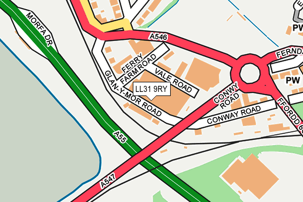
LL31 9RY is located in the Glyn y Marl electoral ward, within the unitary authority of Conwy and the Welsh Parliamentary constituency of Aberconwy. The Local Health Board is Betsi Cadwaladr University and the police force is North Wales. This postcode has been in use since January 1980.


GetTheData
Source: OS OpenMap – Local (Ordnance Survey)
Source: OS VectorMap District (Ordnance Survey)
Licence: Open Government Licence (requires attribution)
| Easting | 279005 |
| Northing | 377933 |
| Latitude | 53.284515 |
| Longitude | -3.816372 |
GetTheData
Source: Open Postcode Geo
Licence: Open Government Licence
| Country | Wales |
| Postcode District | LL31 |
➜ See where LL31 is on a map ➜ Where is Conwy? | |
GetTheData
Source: Land Registry Price Paid Data
Licence: Open Government Licence
Elevation or altitude of LL31 9RY as distance above sea level:
| Metres | Feet | |
|---|---|---|
| Elevation | 0m | 0ft |
Elevation is measured from the approximate centre of the postcode, to the nearest point on an OS contour line from OS Terrain 50, which has contour spacing of ten vertical metres.
➜ How high above sea level am I? Find the elevation of your current position using your device's GPS.
GetTheData
Source: Open Postcode Elevation
Licence: Open Government Licence
| Ward | Glyn Y Marl |
| Constituency | Aberconwy |
GetTheData
Source: ONS Postcode Database
Licence: Open Government Licence
| Arriva Depot (Glan-y-mor Road) | Llandudno Junction | 48m |
| New Road (Ffordd Newydd) | Llandudno Junction | 117m |
| Flyover (Conway Road) | Llandudno Junction | 127m |
| Flyover (Conway Road) | Llandudno Junction | 128m |
| Moorings (Glan-y-mor Road) | Llandudno Junction | 135m |
| Llandudno Junction Station | 0.5km |
| Conwy Station | 1.1km |
| Deganwy Station | 1.6km |
GetTheData
Source: NaPTAN
Licence: Open Government Licence
GetTheData
Source: ONS Postcode Database
Licence: Open Government Licence


➜ Get more ratings from the Food Standards Agency
GetTheData
Source: Food Standards Agency
Licence: FSA terms & conditions
| Last Collection | |||
|---|---|---|---|
| Location | Mon-Fri | Sat | Distance |
| Tesco Llandudno Junction | 17:20 | 11:30 | 244m |
| Castle Street | 17:15 | 12:15 | 840m |
| Victoria Drive | 17:10 | 11:15 | 979m |
GetTheData
Source: Dracos
Licence: Creative Commons Attribution-ShareAlike
The below table lists the International Territorial Level (ITL) codes (formerly Nomenclature of Territorial Units for Statistics (NUTS) codes) and Local Administrative Units (LAU) codes for LL31 9RY:
| ITL 1 Code | Name |
|---|---|
| TLL | Wales |
| ITL 2 Code | Name |
| TLL1 | West Wales and The Valleys |
| ITL 3 Code | Name |
| TLL13 | Conwy and Denbighshire |
| LAU 1 Code | Name |
| W06000003 | Conwy |
GetTheData
Source: ONS Postcode Directory
Licence: Open Government Licence
The below table lists the Census Output Area (OA), Lower Layer Super Output Area (LSOA), and Middle Layer Super Output Area (MSOA) for LL31 9RY:
| Code | Name | |
|---|---|---|
| OA | W00000877 | |
| LSOA | W01000165 | Conwy 006C |
| MSOA | W02000032 | Conwy 006 |
GetTheData
Source: ONS Postcode Directory
Licence: Open Government Licence
| LL31 9SB | Glanymor Road | 32m |
| LL31 9RU | Glanymor Road | 52m |
| LL31 9SH | Vale Road | 72m |
| LL31 9SG | Ferry Farm Road | 99m |
| LL31 9SN | Glanymor Road | 112m |
| LL31 9SR | Albert Drive | 234m |
| LL31 9LU | Conway Road | 242m |
| LL31 9PP | St Georges Drive | 267m |
| LL31 9NU | Victoria Drive | 291m |
| LL31 9LT | Conway Road | 319m |
GetTheData
Source: Open Postcode Geo; Land Registry Price Paid Data
Licence: Open Government Licence