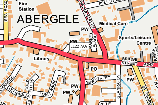
LL22 7AA lies on Market Street in Abergele. LL22 7AA is located in the Pen-sarn Pentre Mawr electoral ward, within the unitary authority of Conwy and the Welsh Parliamentary constituency of Clwyd West. The Local Health Board is Betsi Cadwaladr University and the police force is North Wales. This postcode has been in use since January 1980.


GetTheData
Source: OS OpenMap – Local (Ordnance Survey)
Source: OS VectorMap District (Ordnance Survey)
Licence: Open Government Licence (requires attribution)
| Easting | 294564 |
| Northing | 377572 |
| Latitude | 53.284597 |
| Longitude | -3.582973 |
GetTheData
Source: Open Postcode Geo
Licence: Open Government Licence
| Street | Market Street |
| Town/City | Abergele |
| Country | Wales |
| Postcode District | LL22 |
➜ See where LL22 is on a map ➜ Where is Abergele? | |
GetTheData
Source: Land Registry Price Paid Data
Licence: Open Government Licence
Elevation or altitude of LL22 7AA as distance above sea level:
| Metres | Feet | |
|---|---|---|
| Elevation | 20m | 66ft |
Elevation is measured from the approximate centre of the postcode, to the nearest point on an OS contour line from OS Terrain 50, which has contour spacing of ten vertical metres.
➜ How high above sea level am I? Find the elevation of your current position using your device's GPS.
GetTheData
Source: Open Postcode Elevation
Licence: Open Government Licence
| Ward | Pen-sarn Pentre Mawr |
| Constituency | Clwyd West |
GetTheData
Source: ONS Postcode Database
Licence: Open Government Licence
34, MARKET STREET, ABERGELE, LL22 7AA 2021 17 JUN £133,000 |
18, MARKET STREET, ABERGELE, LL22 7AA 1997 12 FEB £20,500 |
GetTheData
Source: HM Land Registry Price Paid Data
Licence: Contains HM Land Registry data © Crown copyright and database right 2025. This data is licensed under the Open Government Licence v3.0.
| George & Dragon (Market Street) | Abergele | 36m |
| Bowling Green (Water Street) | Abergele | 159m |
| Bowling Green (Water Street) | Abergele | 163m |
| Tesco Car Park (Water Street) | Abergele | 214m |
| St Paul`s Methodist Church (Bridge Street) | Abergele | 218m |
| Abergele & Pensarn Station | 1.1km |
GetTheData
Source: NaPTAN
Licence: Open Government Licence
| Median download speed | 21.9Mbps |
| Average download speed | 28.1Mbps |
| Maximum download speed | 80.00Mbps |
| Median upload speed | 1.2Mbps |
| Average upload speed | 4.4Mbps |
| Maximum upload speed | 20.00Mbps |
GetTheData
Source: Ofcom
Licence: Ofcom Terms of Use (requires attribution)
Estimated total energy consumption in LL22 7AA by fuel type, 2015.
| Consumption (kWh) | 120,563 |
|---|---|
| Meter count | 13 |
| Mean (kWh/meter) | 9,274 |
| Median (kWh/meter) | 3,833 |
| Consumption (kWh) | 53,773 |
|---|---|
| Meter count | 6 |
| Mean (kWh/meter) | 8,962 |
| Median (kWh/meter) | 2,645 |
GetTheData
Source: Postcode level gas estimates: 2015 (experimental)
Source: Postcode level electricity estimates: 2015 (experimental)
Licence: Open Government Licence
GetTheData
Source: ONS Postcode Database
Licence: Open Government Licence


➜ Get more ratings from the Food Standards Agency
GetTheData
Source: Food Standards Agency
Licence: FSA terms & conditions
| Last Collection | |||
|---|---|---|---|
| Location | Mon-Fri | Sat | Distance |
| Maes Y Dre | 16:45 | 11:00 | 448m |
| Marford Drive | 16:45 | 11:00 | 669m |
| Tan Yr Wylfa | 16:45 | 11:00 | 786m |
GetTheData
Source: Dracos
Licence: Creative Commons Attribution-ShareAlike
The below table lists the International Territorial Level (ITL) codes (formerly Nomenclature of Territorial Units for Statistics (NUTS) codes) and Local Administrative Units (LAU) codes for LL22 7AA:
| ITL 1 Code | Name |
|---|---|
| TLL | Wales |
| ITL 2 Code | Name |
| TLL1 | West Wales and The Valleys |
| ITL 3 Code | Name |
| TLL13 | Conwy and Denbighshire |
| LAU 1 Code | Name |
| W06000003 | Conwy |
GetTheData
Source: ONS Postcode Directory
Licence: Open Government Licence
The below table lists the Census Output Area (OA), Lower Layer Super Output Area (LSOA), and Middle Layer Super Output Area (MSOA) for LL22 7AA:
| Code | Name | |
|---|---|---|
| OA | W00000953 | |
| LSOA | W01000178 | Conwy 010E |
| MSOA | W02000036 | Conwy 010 |
GetTheData
Source: ONS Postcode Directory
Licence: Open Government Licence
| LL22 7SW | Ty Mawr | 65m |
| LL22 7AG | Market Street | 65m |
| LL22 7AF | Market Street | 71m |
| LL22 7SH | Water Street | 85m |
| LL22 7AW | Chapel Street | 87m |
| LL22 7YU | Harp Court | 104m |
| LL22 7AH | Bee Gardens | 119m |
| LL22 7BE | New Street | 120m |
| LL22 7SR | Water Street | 127m |
| LL22 7AP | Pen Y Banc | 167m |
GetTheData
Source: Open Postcode Geo; Land Registry Price Paid Data
Licence: Open Government Licence