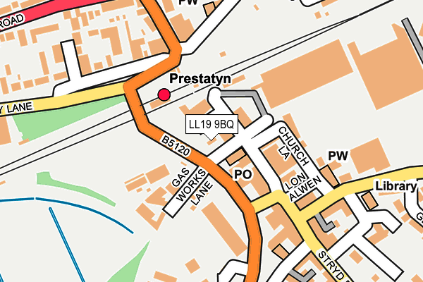
LL19 9BQ lies on Bridge Road in Prestatyn. LL19 9BQ is located in the Prestatyn Central electoral ward, within the unitary authority of Denbighshire and the Welsh Parliamentary constituency of Vale of Clwyd. The Local Health Board is Betsi Cadwaladr University and the police force is North Wales. This postcode has been in use since June 1998.


GetTheData
Source: OS OpenMap – Local (Ordnance Survey)
Source: OS VectorMap District (Ordnance Survey)
Licence: Open Government Licence (requires attribution)
| Easting | 306459 |
| Northing | 383006 |
| Latitude | 53.335662 |
| Longitude | -3.406218 |
GetTheData
Source: Open Postcode Geo
Licence: Open Government Licence
| Street | Bridge Road |
| Town/City | Prestatyn |
| Country | Wales |
| Postcode District | LL19 |
➜ See where LL19 is on a map ➜ Where is Prestatyn? | |
GetTheData
Source: Land Registry Price Paid Data
Licence: Open Government Licence
Elevation or altitude of LL19 9BQ as distance above sea level:
| Metres | Feet | |
|---|---|---|
| Elevation | 10m | 33ft |
Elevation is measured from the approximate centre of the postcode, to the nearest point on an OS contour line from OS Terrain 50, which has contour spacing of ten vertical metres.
➜ How high above sea level am I? Find the elevation of your current position using your device's GPS.
GetTheData
Source: Open Postcode Elevation
Licence: Open Government Licence
| Ward | Prestatyn Central |
| Constituency | Vale Of Clwyd |
GetTheData
Source: ONS Postcode Database
Licence: Open Government Licence
FLAT, DECOR 8, BRIDGE ROAD, PRESTATYN, LL19 9BQ 1997 5 DEC £55,000 |
GetTheData
Source: HM Land Registry Price Paid Data
Licence: Contains HM Land Registry data © Crown copyright and database right 2025. This data is licensed under the Open Government Licence v3.0.
| Royal Victoria Hotel (Bastion Road) | Prestatyn | 169m |
| Royal Victoria Hotel (Bastion Road) | Prestatyn | 178m |
| Station Road | Prestatyn | 181m |
| King`s Avenue (High Street) | Prestatyn | 186m |
| Sandy Lane | Prestatyn | 260m |
| Prestatyn Station | 0.1km |
GetTheData
Source: NaPTAN
Licence: Open Government Licence
GetTheData
Source: ONS Postcode Database
Licence: Open Government Licence


➜ Get more ratings from the Food Standards Agency
GetTheData
Source: Food Standards Agency
Licence: FSA terms & conditions
| Last Collection | |||
|---|---|---|---|
| Location | Mon-Fri | Sat | Distance |
| Prestatyn Main Post Office | 17:25 | 12:00 | 60m |
| Shore Road | 16:15 | 09:00 | 2,714m |
| Trelawnyn Road | 16:45 | 09:30 | 3,648m |
GetTheData
Source: Dracos
Licence: Creative Commons Attribution-ShareAlike
The below table lists the International Territorial Level (ITL) codes (formerly Nomenclature of Territorial Units for Statistics (NUTS) codes) and Local Administrative Units (LAU) codes for LL19 9BQ:
| ITL 1 Code | Name |
|---|---|
| TLL | Wales |
| ITL 2 Code | Name |
| TLL1 | West Wales and The Valleys |
| ITL 3 Code | Name |
| TLL13 | Conwy and Denbighshire |
| LAU 1 Code | Name |
| W06000004 | Denbighshire |
GetTheData
Source: ONS Postcode Directory
Licence: Open Government Licence
The below table lists the Census Output Area (OA), Lower Layer Super Output Area (LSOA), and Middle Layer Super Output Area (MSOA) for LL19 9BQ:
| Code | Name | |
|---|---|---|
| OA | W00001134 | |
| LSOA | W01000213 | Denbighshire 002A |
| MSOA | W02000043 | Denbighshire 002 |
GetTheData
Source: ONS Postcode Directory
Licence: Open Government Licence
| LL19 9BB | High Street | 47m |
| LL19 7EA | Bastion Road | 112m |
| LL19 7ER | Bridge Road | 113m |
| LL19 7SE | Gas Works Lane | 139m |
| LL19 9LR | Nant Hall Road | 172m |
| LL19 9BE | High Street | 175m |
| LL19 7ES | Bastion Road | 179m |
| LL19 7SG | Sandy Lane | 185m |
| LL19 7EQ | Stable Gate | 186m |
| LL19 7SB | Sandy Lane | 201m |
GetTheData
Source: Open Postcode Geo; Land Registry Price Paid Data
Licence: Open Government Licence