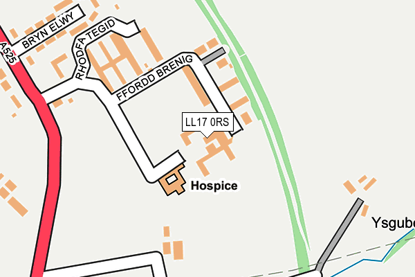
LL17 0RS is located in the St Asaph East electoral ward, within the unitary authority of Denbighshire and the Welsh Parliamentary constituency of Vale of Clwyd. The Local Health Board is Betsi Cadwaladr University and the police force is North Wales. This postcode has been in use since August 2016.


GetTheData
Source: OS OpenMap – Local (Ordnance Survey)
Source: OS VectorMap District (Ordnance Survey)
Licence: Open Government Licence (requires attribution)
| Easting | 304429 |
| Northing | 373629 |
| Latitude | 53.251054 |
| Longitude | -3.433869 |
GetTheData
Source: Open Postcode Geo
Licence: Open Government Licence
| Country | Wales |
| Postcode District | LL17 |
➜ See where LL17 is on a map ➜ Where is St Asaph? | |
GetTheData
Source: Land Registry Price Paid Data
Licence: Open Government Licence
Elevation or altitude of LL17 0RS as distance above sea level:
| Metres | Feet | |
|---|---|---|
| Elevation | 40m | 131ft |
Elevation is measured from the approximate centre of the postcode, to the nearest point on an OS contour line from OS Terrain 50, which has contour spacing of ten vertical metres.
➜ How high above sea level am I? Find the elevation of your current position using your device's GPS.
GetTheData
Source: Open Postcode Elevation
Licence: Open Government Licence
| Ward | St Asaph East |
| Constituency | Vale Of Clwyd |
GetTheData
Source: ONS Postcode Database
Licence: Open Government Licence
| Hm Stanley Hospital (Upper Denbigh Road) | St Asaph | 204m |
| Bryn Asaph (Upper Denbigh Road) | St Asaph | 277m |
| Bryn Asaph (Upper Denbigh Road) | St Asaph | 287m |
| Hm Stanley Hospital (Upper Denbigh Road) | St Asaph | 345m |
| Bishops Walk (Upper Denbigh Road) | St Asaph | 406m |
GetTheData
Source: NaPTAN
Licence: Open Government Licence
Estimated total energy consumption in LL17 0RS by fuel type, 2015.
| Consumption (kWh) | 39,022 |
|---|---|
| Meter count | 8 |
| Mean (kWh/meter) | 4,878 |
| Median (kWh/meter) | 3,665 |
| Consumption (kWh) | 2,483 |
|---|---|
| Meter count | 10 |
| Mean (kWh/meter) | 248 |
| Median (kWh/meter) | 137 |
GetTheData
Source: Postcode level gas estimates: 2015 (experimental)
Source: Postcode level electricity estimates: 2015 (experimental)
Licence: Open Government Licence
GetTheData
Source: ONS Postcode Database
Licence: Open Government Licence


➜ Get more ratings from the Food Standards Agency
GetTheData
Source: Food Standards Agency
Licence: FSA terms & conditions
| Last Collection | |||
|---|---|---|---|
| Location | Mon-Fri | Sat | Distance |
| Foxtons | 17:00 | 11:00 | 1,052m |
| Eryl | 16:15 | 08:00 | 1,176m |
| British School | 16:00 | 08:00 | 1,963m |
GetTheData
Source: Dracos
Licence: Creative Commons Attribution-ShareAlike
The below table lists the International Territorial Level (ITL) codes (formerly Nomenclature of Territorial Units for Statistics (NUTS) codes) and Local Administrative Units (LAU) codes for LL17 0RS:
| ITL 1 Code | Name |
|---|---|
| TLL | Wales |
| ITL 2 Code | Name |
| TLL1 | West Wales and The Valleys |
| ITL 3 Code | Name |
| TLL13 | Conwy and Denbighshire |
| LAU 1 Code | Name |
| W06000004 | Denbighshire |
GetTheData
Source: ONS Postcode Directory
Licence: Open Government Licence
The below table lists the Census Output Area (OA), Lower Layer Super Output Area (LSOA), and Middle Layer Super Output Area (MSOA) for LL17 0RS:
| Code | Name | |
|---|---|---|
| OA | W00001314 | |
| LSOA | W01000245 | Denbighshire 010A |
| MSOA | W02000051 | Denbighshire 010 |
GetTheData
Source: ONS Postcode Directory
Licence: Open Government Licence
| LL17 0RU | Bryn Elwy | 273m |
| LL17 0LW | Upper Denbigh Road | 291m |
| LL17 0SX | Llys Dyffryn | 359m |
| LL17 0RR | Upper Denbigh Road | 360m |
| LL17 0UA | Llys Clwyd | 525m |
| LL17 0SU | Bishops Walk | 560m |
| LL17 0SQ | Llwyn Onn | 585m |
| LL17 0SZ | Bishops Walk | 587m |
| LL17 0SJ | Llys Alun | 603m |
| LL17 0RW | Upper Denbigh Road | 619m |
GetTheData
Source: Open Postcode Geo; Land Registry Price Paid Data
Licence: Open Government Licence