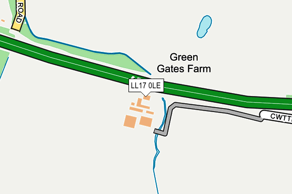
LL17 0LE is located in the St Asaph West electoral ward, within the unitary authority of Denbighshire and the Welsh Parliamentary constituency of Vale of Clwyd. The Local Health Board is Betsi Cadwaladr University and the police force is North Wales. This postcode has been in use since February 2013.


GetTheData
Source: OS OpenMap – Local (Ordnance Survey)
Source: OS VectorMap District (Ordnance Survey)
Licence: Open Government Licence (requires attribution)
| Easting | 302202 |
| Northing | 374667 |
| Latitude | 53.259959 |
| Longitude | -3.467553 |
GetTheData
Source: Open Postcode Geo
Licence: Open Government Licence
| Country | Wales |
| Postcode District | LL17 |
➜ See where LL17 is on a map | |
GetTheData
Source: Land Registry Price Paid Data
Licence: Open Government Licence
Elevation or altitude of LL17 0LE as distance above sea level:
| Metres | Feet | |
|---|---|---|
| Elevation | 20m | 66ft |
Elevation is measured from the approximate centre of the postcode, to the nearest point on an OS contour line from OS Terrain 50, which has contour spacing of ten vertical metres.
➜ How high above sea level am I? Find the elevation of your current position using your device's GPS.
GetTheData
Source: Open Postcode Elevation
Licence: Open Government Licence
| Ward | St Asaph West |
| Constituency | Vale Of Clwyd |
GetTheData
Source: ONS Postcode Database
Licence: Open Government Licence
| Business Park (Glascoed Road) | Ty'n-y-ffordd | 819m |
| Business Park (Glascoed Road) | Coed Esgob | 825m |
| Business Park (Glascoed Road) | Glascoed | 938m |
| Business Park (Ffordd William Morgan) | St Asaph | 947m |
| Talardy Hotel (The Roe) | The Roe | 960m |
GetTheData
Source: NaPTAN
Licence: Open Government Licence
GetTheData
Source: ONS Postcode Database
Licence: Open Government Licence


➜ Get more ratings from the Food Standards Agency
GetTheData
Source: Food Standards Agency
Licence: FSA terms & conditions
| Last Collection | |||
|---|---|---|---|
| Location | Mon-Fri | Sat | Distance |
| St Asaph Business Park | 16:45 | 10:30 | 788m |
| St Asaph Business Park | 18:30 | 09:00 | 1,104m |
| St Asaph Business Park | 18:30 | 1,167m | |
GetTheData
Source: Dracos
Licence: Creative Commons Attribution-ShareAlike
The below table lists the International Territorial Level (ITL) codes (formerly Nomenclature of Territorial Units for Statistics (NUTS) codes) and Local Administrative Units (LAU) codes for LL17 0LE:
| ITL 1 Code | Name |
|---|---|
| TLL | Wales |
| ITL 2 Code | Name |
| TLL1 | West Wales and The Valleys |
| ITL 3 Code | Name |
| TLL13 | Conwy and Denbighshire |
| LAU 1 Code | Name |
| W06000004 | Denbighshire |
GetTheData
Source: ONS Postcode Directory
Licence: Open Government Licence
The below table lists the Census Output Area (OA), Lower Layer Super Output Area (LSOA), and Middle Layer Super Output Area (MSOA) for LL17 0LE:
| Code | Name | |
|---|---|---|
| OA | W00001319 | |
| LSOA | W01000246 | Denbighshire 010B |
| MSOA | W02000051 | Denbighshire 010 |
GetTheData
Source: ONS Postcode Directory
Licence: Open Government Licence
| LL17 0LF | Cwttir Lane | 466m |
| LL17 0PY | Pant Glas | 764m |
| LL17 0PU | Tan Y Bryn | 819m |
| LL17 0HX | Hen Waliau | 847m |
| LL17 0PP | Heol Esgob | 878m |
| LL17 0PT | Ffordd Siarl | 886m |
| LL17 0JE | Bowen Court | 900m |
| LL17 0LH | Glascoed Road | 902m |
| LL17 0LZ | Erw Lan | 932m |
| LL17 0PX | Cae Winefride | 959m |
GetTheData
Source: Open Postcode Geo; Land Registry Price Paid Data
Licence: Open Government Licence