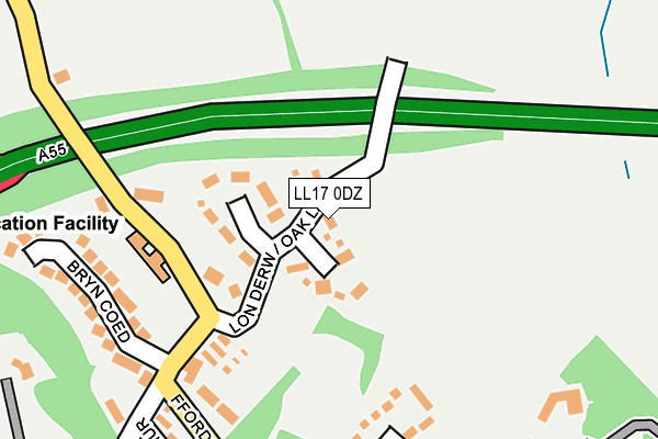
LL17 0DZ lies on Oak Lane in St. Asaph. LL17 0DZ is located in the St Asaph East electoral ward, within the unitary authority of Denbighshire and the Welsh Parliamentary constituency of Vale of Clwyd. The Local Health Board is Betsi Cadwaladr University and the police force is North Wales. This postcode has been in use since June 2000.


GetTheData
Source: OS OpenMap – Local (Ordnance Survey)
Source: OS VectorMap District (Ordnance Survey)
Licence: Open Government Licence (requires attribution)
| Easting | 303817 |
| Northing | 374902 |
| Latitude | 53.262383 |
| Longitude | -3.443424 |
GetTheData
Source: Open Postcode Geo
Licence: Open Government Licence
| Street | Oak Lane |
| Town/City | St. Asaph |
| Country | Wales |
| Postcode District | LL17 |
➜ See where LL17 is on a map ➜ Where is St Asaph? | |
GetTheData
Source: Land Registry Price Paid Data
Licence: Open Government Licence
Elevation or altitude of LL17 0DZ as distance above sea level:
| Metres | Feet | |
|---|---|---|
| Elevation | 30m | 98ft |
Elevation is measured from the approximate centre of the postcode, to the nearest point on an OS contour line from OS Terrain 50, which has contour spacing of ten vertical metres.
➜ How high above sea level am I? Find the elevation of your current position using your device's GPS.
GetTheData
Source: Open Postcode Elevation
Licence: Open Government Licence
| Ward | St Asaph East |
| Constituency | Vale Of Clwyd |
GetTheData
Source: ONS Postcode Database
Licence: Open Government Licence
LITTLE ORCHARD, OAK LANE, ST. ASAPH, LL17 0DZ 2007 30 MAR £395,000 |
LITTLE ORCHARD, OAK LANE, ST. ASAPH, LL17 0DZ 2002 1 MAR £249,500 |
HOLMFIELD, OAK LANE, ST. ASAPH, LL17 0DZ 1999 14 DEC £194,500 |
GetTheData
Source: HM Land Registry Price Paid Data
Licence: Contains HM Land Registry data © Crown copyright and database right 2025. This data is licensed under the Open Government Licence v3.0.
| Cathedral (High Street) | St Asaph | 536m |
| Cathedral (High Street) | St Asaph | 550m |
| Plas Elwy Hotel (The Roe) | The Roe | 633m |
| Swan Inn (The Roe) | The Roe | 640m |
| Roe Park (The Roe) | The Roe | 650m |
GetTheData
Source: NaPTAN
Licence: Open Government Licence
| Percentage of properties with Next Generation Access | 100.0% |
| Percentage of properties with Superfast Broadband | 100.0% |
| Percentage of properties with Ultrafast Broadband | 0.0% |
| Percentage of properties with Full Fibre Broadband | 0.0% |
Superfast Broadband is between 30Mbps and 300Mbps
Ultrafast Broadband is > 300Mbps
| Percentage of properties unable to receive 2Mbps | 0.0% |
| Percentage of properties unable to receive 5Mbps | 0.0% |
| Percentage of properties unable to receive 10Mbps | 0.0% |
| Percentage of properties unable to receive 30Mbps | 0.0% |
GetTheData
Source: Ofcom
Licence: Ofcom Terms of Use (requires attribution)
GetTheData
Source: ONS Postcode Database
Licence: Open Government Licence


➜ Get more ratings from the Food Standards Agency
GetTheData
Source: Food Standards Agency
Licence: FSA terms & conditions
| Last Collection | |||
|---|---|---|---|
| Location | Mon-Fri | Sat | Distance |
| Foxtons | 17:00 | 11:00 | 874m |
| Eryl | 16:15 | 08:00 | 2,133m |
| St Asaph Business Park | 16:45 | 10:30 | 2,137m |
GetTheData
Source: Dracos
Licence: Creative Commons Attribution-ShareAlike
The below table lists the International Territorial Level (ITL) codes (formerly Nomenclature of Territorial Units for Statistics (NUTS) codes) and Local Administrative Units (LAU) codes for LL17 0DZ:
| ITL 1 Code | Name |
|---|---|
| TLL | Wales |
| ITL 2 Code | Name |
| TLL1 | West Wales and The Valleys |
| ITL 3 Code | Name |
| TLL13 | Conwy and Denbighshire |
| LAU 1 Code | Name |
| W06000004 | Denbighshire |
GetTheData
Source: ONS Postcode Directory
Licence: Open Government Licence
The below table lists the Census Output Area (OA), Lower Layer Super Output Area (LSOA), and Middle Layer Super Output Area (MSOA) for LL17 0DZ:
| Code | Name | |
|---|---|---|
| OA | W00001317 | |
| LSOA | W01000245 | Denbighshire 010A |
| MSOA | W02000051 | Denbighshire 010 |
GetTheData
Source: ONS Postcode Directory
Licence: Open Government Licence
| LL17 0DX | Oak Close | 95m |
| LL17 0LB | Yew Tree Close | 101m |
| LL17 0DE | Mount Road | 232m |
| LL17 0DQ | Bryn Coed | 238m |
| LL17 0DG | Mount Road | 242m |
| LL17 0DW | Rhodfa Glenys | 282m |
| LL17 0DF | Mount Road | 324m |
| LL17 0DP | Bryn Arthur | 325m |
| LL17 0DJ | Llys Trewithan | 361m |
| LL17 0DD | Mount Road | 373m |
GetTheData
Source: Open Postcode Geo; Land Registry Price Paid Data
Licence: Open Government Licence