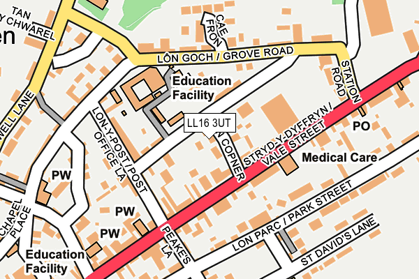
LL16 3UT lies on Lon Copner in Denbigh. LL16 3UT is located in the Denbigh Caledfryn Henllan electoral ward, within the unitary authority of Denbighshire and the Welsh Parliamentary constituency of Vale of Clwyd. The Local Health Board is Betsi Cadwaladr University and the police force is North Wales. This postcode has been in use since January 1980.


GetTheData
Source: OS OpenMap – Local (Ordnance Survey)
Source: OS VectorMap District (Ordnance Survey)
Licence: Open Government Licence (requires attribution)
| Easting | 305488 |
| Northing | 366351 |
| Latitude | 53.185827 |
| Longitude | -3.415842 |
GetTheData
Source: Open Postcode Geo
Licence: Open Government Licence
| Street | Lon Copner |
| Town/City | Denbigh |
| Country | Wales |
| Postcode District | LL16 |
➜ See where LL16 is on a map ➜ Where is Denbigh? | |
GetTheData
Source: Land Registry Price Paid Data
Licence: Open Government Licence
Elevation or altitude of LL16 3UT as distance above sea level:
| Metres | Feet | |
|---|---|---|
| Elevation | 70m | 230ft |
Elevation is measured from the approximate centre of the postcode, to the nearest point on an OS contour line from OS Terrain 50, which has contour spacing of ten vertical metres.
➜ How high above sea level am I? Find the elevation of your current position using your device's GPS.
GetTheData
Source: Open Postcode Elevation
Licence: Open Government Licence
| Ward | Denbigh Caledfryn Henllan |
| Constituency | Vale Of Clwyd |
GetTheData
Source: ONS Postcode Database
Licence: Open Government Licence
THREE FAIRWAYS, LON COPNER, DENBIGH, LL16 3UT 2017 25 AUG £112,000 |
CEFN CELYN, LON COPNER, DENBIGH, LL16 3UT 2016 6 JAN £225,000 |
LLWYDFA, LON COPNER, DENBIGH, LL16 3UT 2009 16 OCT £174,999 |
GetTheData
Source: HM Land Registry Price Paid Data
Licence: Contains HM Land Registry data © Crown copyright and database right 2024. This data is licensed under the Open Government Licence v3.0.
| Police Station (Vale Street) | Denbigh | 91m |
| Police Station (Vale Street) | Denbigh | 116m |
| Lidl (Vale Street) | Denbigh | 124m |
| Lidl (Vale Street) | Denbigh | 180m |
| Kwiksave Car Park (Grounds) | Denbigh | 277m |
GetTheData
Source: NaPTAN
Licence: Open Government Licence
| Percentage of properties with Next Generation Access | 100.0% |
| Percentage of properties with Superfast Broadband | 100.0% |
| Percentage of properties with Ultrafast Broadband | 0.0% |
| Percentage of properties with Full Fibre Broadband | 0.0% |
Superfast Broadband is between 30Mbps and 300Mbps
Ultrafast Broadband is > 300Mbps
| Median download speed | 22.1Mbps |
| Average download speed | 19.7Mbps |
| Maximum download speed | 23.72Mbps |
| Median upload speed | 1.2Mbps |
| Average upload speed | 1.1Mbps |
| Maximum upload speed | 1.22Mbps |
| Percentage of properties unable to receive 2Mbps | 0.0% |
| Percentage of properties unable to receive 5Mbps | 0.0% |
| Percentage of properties unable to receive 10Mbps | 0.0% |
| Percentage of properties unable to receive 30Mbps | 0.0% |
GetTheData
Source: Ofcom
Licence: Ofcom Terms of Use (requires attribution)
GetTheData
Source: ONS Postcode Database
Licence: Open Government Licence


➜ Get more ratings from the Food Standards Agency
GetTheData
Source: Food Standards Agency
Licence: FSA terms & conditions
| Last Collection | |||
|---|---|---|---|
| Location | Mon-Fri | Sat | Distance |
| Vale Street | 17:20 | 10:00 | 193m |
| Fron | 16:55 | 10:45 | 467m |
| Ruthin Road | 16:35 | 10:15 | 574m |
GetTheData
Source: Dracos
Licence: Creative Commons Attribution-ShareAlike
The below table lists the International Territorial Level (ITL) codes (formerly Nomenclature of Territorial Units for Statistics (NUTS) codes) and Local Administrative Units (LAU) codes for LL16 3UT:
| ITL 1 Code | Name |
|---|---|
| TLL | Wales |
| ITL 2 Code | Name |
| TLL1 | West Wales and The Valleys |
| ITL 3 Code | Name |
| TLL13 | Conwy and Denbighshire |
| LAU 1 Code | Name |
| W06000004 | Denbighshire |
GetTheData
Source: ONS Postcode Directory
Licence: Open Government Licence
The below table lists the Census Output Area (OA), Lower Layer Super Output Area (LSOA), and Middle Layer Super Output Area (MSOA) for LL16 3UT:
| Code | Name | |
|---|---|---|
| OA | W00001038 | |
| LSOA | W01000194 | Denbighshire 011A |
| MSOA | W02000052 | Denbighshire 011 |
GetTheData
Source: ONS Postcode Directory
Licence: Open Government Licence
| LL16 3US | Rose Villas | 69m |
| LL16 3UW | Middle Lane | 71m |
| LL16 3UR | Middle Lane | 80m |
| LL16 3BW | Vale Street | 87m |
| LL16 3AU | Vale Street | 93m |
| LL16 3AP | Vale Street | 96m |
| LL16 3UL | Post Office Lane | 110m |
| LL16 3UN | Post Office Lane | 130m |
| LL16 3UG | Post Office Lane | 130m |
| LL16 3UH | Post Office Lane | 148m |
GetTheData
Source: Open Postcode Geo; Land Registry Price Paid Data
Licence: Open Government Licence