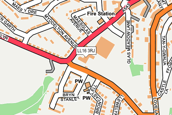
LL16 3RJ is located in the Denbigh Caledfryn Henllan electoral ward, within the unitary authority of Denbighshire and the Welsh Parliamentary constituency of Vale of Clwyd. The Local Health Board is Betsi Cadwaladr University and the police force is North Wales. This postcode has been in use since December 1997.


GetTheData
Source: OS OpenMap – Local (Ordnance Survey)
Source: OS VectorMap District (Ordnance Survey)
Licence: Open Government Licence (requires attribution)
| Easting | 304817 |
| Northing | 365867 |
| Latitude | 53.181373 |
| Longitude | -3.425738 |
GetTheData
Source: Open Postcode Geo
Licence: Open Government Licence
| Country | Wales |
| Postcode District | LL16 |
➜ See where LL16 is on a map ➜ Where is Denbigh? | |
GetTheData
Source: Land Registry Price Paid Data
Licence: Open Government Licence
Elevation or altitude of LL16 3RJ as distance above sea level:
| Metres | Feet | |
|---|---|---|
| Elevation | 100m | 328ft |
Elevation is measured from the approximate centre of the postcode, to the nearest point on an OS contour line from OS Terrain 50, which has contour spacing of ten vertical metres.
➜ How high above sea level am I? Find the elevation of your current position using your device's GPS.
GetTheData
Source: Open Postcode Elevation
Licence: Open Government Licence
| Ward | Denbigh Caledfryn Henllan |
| Constituency | Vale Of Clwyd |
GetTheData
Source: ONS Postcode Database
Licence: Open Government Licence
| Morrisons (Grounds) | Denbigh | 129m |
| Llewelyn`s Estate (Lon Llewelyn) | Denbigh | 191m |
| Llewelyn`s Estate (Lon Llewelyn) | Denbigh | 194m |
| Myddelton Avenue (Lon Llewelyn) | Denbigh | 206m |
| Myddelton Avenue (Lon Llewelyn) | Denbigh | 207m |
GetTheData
Source: NaPTAN
Licence: Open Government Licence
GetTheData
Source: ONS Postcode Database
Licence: Open Government Licence


➜ Get more ratings from the Food Standards Agency
GetTheData
Source: Food Standards Agency
Licence: FSA terms & conditions
| Last Collection | |||
|---|---|---|---|
| Location | Mon-Fri | Sat | Distance |
| Vale Street | 17:20 | 10:00 | 643m |
| Fron | 16:55 | 10:45 | 1,293m |
| Ruthin Road | 16:35 | 10:15 | 1,325m |
GetTheData
Source: Dracos
Licence: Creative Commons Attribution-ShareAlike
The below table lists the International Territorial Level (ITL) codes (formerly Nomenclature of Territorial Units for Statistics (NUTS) codes) and Local Administrative Units (LAU) codes for LL16 3RJ:
| ITL 1 Code | Name |
|---|---|
| TLL | Wales |
| ITL 2 Code | Name |
| TLL1 | West Wales and The Valleys |
| ITL 3 Code | Name |
| TLL13 | Conwy and Denbighshire |
| LAU 1 Code | Name |
| W06000004 | Denbighshire |
GetTheData
Source: ONS Postcode Directory
Licence: Open Government Licence
The below table lists the Census Output Area (OA), Lower Layer Super Output Area (LSOA), and Middle Layer Super Output Area (MSOA) for LL16 3RJ:
| Code | Name | |
|---|---|---|
| OA | W00001059 | |
| LSOA | W01000199 | Denbighshire 011C |
| MSOA | W02000052 | Denbighshire 011 |
GetTheData
Source: ONS Postcode Directory
Licence: Open Government Licence
| LL16 3RG | Smithfield Road | 71m |
| LL16 3RH | Myddleton Avenue | 130m |
| LL16 3RF | Maesglas | 136m |
| LL16 3NT | Bryn Stanley | 139m |
| LL16 3RN | Lon Llewelyn | 143m |
| LL16 3NS | Bron Castell | 156m |
| LL16 3LW | Ffordd Las | 202m |
| LL16 3RL | Myddleton Avenue | 203m |
| LL16 3PS | Maes Y Goron | 204m |
| LL16 3LP | Lenten Pool | 220m |
GetTheData
Source: Open Postcode Geo; Land Registry Price Paid Data
Licence: Open Government Licence