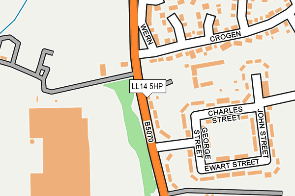
LL14 5HP is located in the Chirk North electoral ward, within the unitary authority of Wrexham and the Welsh Parliamentary constituency of Clwyd South. The Local Health Board is Betsi Cadwaladr University and the police force is North Wales. This postcode has been in use since January 1980.


GetTheData
Source: OS OpenMap – Local (Ordnance Survey)
Source: OS VectorMap District (Ordnance Survey)
Licence: Open Government Licence (requires attribution)
| Easting | 328933 |
| Northing | 338895 |
| Latitude | 52.942734 |
| Longitude | -3.058989 |
GetTheData
Source: Open Postcode Geo
Licence: Open Government Licence
| Country | Wales |
| Postcode District | LL14 |
➜ See where LL14 is on a map ➜ Where is Chirk? | |
GetTheData
Source: Land Registry Price Paid Data
Licence: Open Government Licence
Elevation or altitude of LL14 5HP as distance above sea level:
| Metres | Feet | |
|---|---|---|
| Elevation | 100m | 328ft |
Elevation is measured from the approximate centre of the postcode, to the nearest point on an OS contour line from OS Terrain 50, which has contour spacing of ten vertical metres.
➜ How high above sea level am I? Find the elevation of your current position using your device's GPS.
GetTheData
Source: Open Postcode Elevation
Licence: Open Government Licence
| Ward | Chirk North |
| Constituency | Clwyd South |
GetTheData
Source: ONS Postcode Database
Licence: Open Government Licence
BRIARBANK, HOLYHEAD ROAD, CHIRK, WREXHAM, LL14 5HP 2016 1 DEC £110,000 |
GetTheData
Source: HM Land Registry Price Paid Data
Licence: Contains HM Land Registry data © Crown copyright and database right 2025. This data is licensed under the Open Government Licence v3.0.
| Lodgevale Park Entrance (B5070) | Chirk | 116m |
| Lodgevale Park Entrance (B5070) | Chirk | 118m |
| Rhosywaun (B5070) | Chirk | 149m |
| Rhosywaun (B5070) | Chirk | 153m |
| Wern (B5070) | Chirk | 206m |
| Chirk Station | 1.2km |
| Ruabon Station | 5.1km |
GetTheData
Source: NaPTAN
Licence: Open Government Licence
| Percentage of properties with Next Generation Access | 100.0% |
| Percentage of properties with Superfast Broadband | 100.0% |
| Percentage of properties with Ultrafast Broadband | 100.0% |
| Percentage of properties with Full Fibre Broadband | 100.0% |
Superfast Broadband is between 30Mbps and 300Mbps
Ultrafast Broadband is > 300Mbps
| Percentage of properties unable to receive 2Mbps | 0.0% |
| Percentage of properties unable to receive 5Mbps | 0.0% |
| Percentage of properties unable to receive 10Mbps | 0.0% |
| Percentage of properties unable to receive 30Mbps | 0.0% |
GetTheData
Source: Ofcom
Licence: Ofcom Terms of Use (requires attribution)
GetTheData
Source: ONS Postcode Database
Licence: Open Government Licence


➜ Get more ratings from the Food Standards Agency
GetTheData
Source: Food Standards Agency
Licence: FSA terms & conditions
| Last Collection | |||
|---|---|---|---|
| Location | Mon-Fri | Sat | Distance |
| Whitehurst | 09:00 | 09:00 | 1,146m |
| Pentre | 09:00 | 09:00 | 1,869m |
| Chirk Castle | 16:10 | 07:00 | 2,248m |
GetTheData
Source: Dracos
Licence: Creative Commons Attribution-ShareAlike
The below table lists the International Territorial Level (ITL) codes (formerly Nomenclature of Territorial Units for Statistics (NUTS) codes) and Local Administrative Units (LAU) codes for LL14 5HP:
| ITL 1 Code | Name |
|---|---|
| TLL | Wales |
| ITL 2 Code | Name |
| TLL2 | East Wales |
| ITL 3 Code | Name |
| TLL23 | Flintshire and Wrexham |
| LAU 1 Code | Name |
| W06000006 | Wrexham |
GetTheData
Source: ONS Postcode Directory
Licence: Open Government Licence
The below table lists the Census Output Area (OA), Lower Layer Super Output Area (LSOA), and Middle Layer Super Output Area (MSOA) for LL14 5HP:
| Code | Name | |
|---|---|---|
| OA | W00001924 | |
| LSOA | W01000360 | Wrexham 019D |
| MSOA | W02000096 | Wrexham 019 |
GetTheData
Source: ONS Postcode Directory
Licence: Open Government Licence
| LL14 5HW | West View | 41m |
| LL14 5HS | George Street | 112m |
| LL14 5HT | Charles Street | 149m |
| LL14 5BW | Wern | 185m |
| LL14 5BN | Crogen | 194m |
| LL14 5HN | West View | 227m |
| LL14 5LD | South View | 232m |
| LL14 5HU | North View | 234m |
| LL14 5LA | Ewart Street | 239m |
| LL14 5HY | John Street | 259m |
GetTheData
Source: Open Postcode Geo; Land Registry Price Paid Data
Licence: Open Government Licence