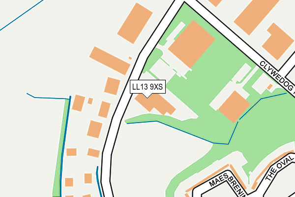
LL13 9XS lies on Clywedog Road South in Wrexham Industrial Estate, Wrexham. LL13 9XS is located in the Holt electoral ward, within the unitary authority of Wrexham and the Welsh Parliamentary constituency of Wrexham. The Local Health Board is Betsi Cadwaladr University and the police force is North Wales. This postcode has been in use since January 1992.


GetTheData
Source: OS OpenMap – Local (Ordnance Survey)
Source: OS VectorMap District (Ordnance Survey)
Licence: Open Government Licence (requires attribution)
| Easting | 336989 |
| Northing | 349206 |
| Latitude | 53.036418 |
| Longitude | -2.941141 |
GetTheData
Source: Open Postcode Geo
Licence: Open Government Licence
| Street | Clywedog Road South |
| Locality | Wrexham Industrial Estate |
| Town/City | Wrexham |
| Country | Wales |
| Postcode District | LL13 |
➜ See where LL13 is on a map | |
GetTheData
Source: Land Registry Price Paid Data
Licence: Open Government Licence
Elevation or altitude of LL13 9XS as distance above sea level:
| Metres | Feet | |
|---|---|---|
| Elevation | 40m | 131ft |
Elevation is measured from the approximate centre of the postcode, to the nearest point on an OS contour line from OS Terrain 50, which has contour spacing of ten vertical metres.
➜ How high above sea level am I? Find the elevation of your current position using your device's GPS.
GetTheData
Source: Open Postcode Elevation
Licence: Open Government Licence
| Ward | Holt |
| Constituency | Wrexham |
GetTheData
Source: ONS Postcode Database
Licence: Open Government Licence
| Pentre Maelor (Bridge Road South) | Pentre Maelor | 484m |
| Pentre Maelor (Bridge Road South) | Pentre Maelor | 494m |
| Bridge Road | Pentre Maelor | 674m |
| Stadex (Coed Aben Road) | Pentre Maelor | 865m |
| Cafe (Coed Aben Road) | Pentre Maelor | 945m |
| Wrexham Central Station | 4km |
| Wrexham General Station | 4.4km |
GetTheData
Source: NaPTAN
Licence: Open Government Licence
| Median download speed | 62.9Mbps |
| Average download speed | 53.2Mbps |
| Maximum download speed | 80.00Mbps |
| Median upload speed | 11.2Mbps |
| Average upload speed | 11.8Mbps |
| Maximum upload speed | 20.00Mbps |
GetTheData
Source: Ofcom
Licence: Ofcom Terms of Use (requires attribution)
Estimated total energy consumption in LL13 9XS by fuel type, 2015.
| Consumption (kWh) | 148,729 |
|---|---|
| Meter count | 7 |
| Mean (kWh/meter) | 21,247 |
| Median (kWh/meter) | 24,035 |
GetTheData
Source: Postcode level gas estimates: 2015 (experimental)
Source: Postcode level electricity estimates: 2015 (experimental)
Licence: Open Government Licence
GetTheData
Source: ONS Postcode Database
Licence: Open Government Licence


➜ Get more ratings from the Food Standards Agency
GetTheData
Source: Food Standards Agency
Licence: FSA terms & conditions
| Last Collection | |||
|---|---|---|---|
| Location | Mon-Fri | Sat | Distance |
| Wrexham Industrial Estate | 18:30 | 1,543m | |
| Cross Lanes | 09:45 | 09:00 | 2,202m |
| Fenwick Drive | 16:00 | 12:00 | 2,600m |
GetTheData
Source: Dracos
Licence: Creative Commons Attribution-ShareAlike
The below table lists the International Territorial Level (ITL) codes (formerly Nomenclature of Territorial Units for Statistics (NUTS) codes) and Local Administrative Units (LAU) codes for LL13 9XS:
| ITL 1 Code | Name |
|---|---|
| TLL | Wales |
| ITL 2 Code | Name |
| TLL2 | East Wales |
| ITL 3 Code | Name |
| TLL23 | Flintshire and Wrexham |
| LAU 1 Code | Name |
| W06000006 | Wrexham |
GetTheData
Source: ONS Postcode Directory
Licence: Open Government Licence
The below table lists the Census Output Area (OA), Lower Layer Super Output Area (LSOA), and Middle Layer Super Output Area (MSOA) for LL13 9XS:
| Code | Name | |
|---|---|---|
| OA | W00002041 | |
| LSOA | W01000383 | Wrexham 020A |
| MSOA | W02000420 | Wrexham 020 |
GetTheData
Source: ONS Postcode Directory
Licence: Open Government Licence
| LL13 9AE | Clywedog Road South | 185m |
| LL13 9PY | Maes Brenin | 250m |
| LL13 9RA | Pilgrim Way | 381m |
| LL13 9XE | Clywedog Road East | 387m |
| LL13 9PT | Bridgeway West | 450m |
| LL13 9PU | The Oval | 452m |
| LL13 9RB | Bridgeway East | 491m |
| LL13 9XN | Clywedog Road North | 531m |
| LL13 0PD | Abenbury | 533m |
| LL13 9PS | Bridge Road | 617m |
GetTheData
Source: Open Postcode Geo; Land Registry Price Paid Data
Licence: Open Government Licence